
Weather whiplash: Second snowfall of season to target Colorado Rockies

The second accumulating snow for the Rocky Mountains in Colorado in a little over a week will continue as another push of chilly air moves into the region, AccuWeather meteorologists say.
The quick-hitting snow and chill has followed three days in a row with high temperatures well into the 70s -- about 15 to 20 degrees Fahrenheit above the historical average -- from Sunday, Monday and Tuesday.
 |
Abrupt temperature changes are common in Denver, as well as along much of the eastern slopes of the Rocky Mountains. These swings can be dramatic and depend largely on which way the wind blows.
When air blows from the southwest or west, the air descends, is compressed and warms substantially. Usually, dry conditions accompany a wind from the west and southwest.
However, when winds flip around to the east or northeast like they will into Thursday, the air ascends and cools, and moisture can be squeezed out of the atmosphere. Temperatures can plummet 20-40 degrees in a matter of a few hours or less.
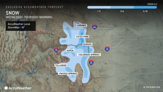
The upcoming flip of the winds at midweek will bring colder air and some snow. However, temperatures will stop in the 20s and 30s in the region, as opposed to the single digits and teens that were measured during the last snow and cold outbreak in late October. That cold snap brought 6-10 inches of snow to the Denver metro area with higher amounts in the foothills and Front Range.
 |
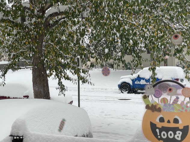
Snow in Denver, Colorado, on Saturday, Oct. 28, 2023. (AccuWeather/Olivia Malachowicz) |
The warmth ahead of the snow and temperatures not that far from freezing during the snow will tend to limit the accumulation outside of the mountains and foothills in this case, AccuWeather Senior Storm Warning Meteorologist Brian Wimer explained.
Road conditions are likely to range from wet to slushy and snow-covered, heading out of town and on to the west into the foothills and south into the Palmer Divide during Thursday morning.
"The snow this week is likely to bring 3 to perhaps 6 inches farther to the west over the foothills and 6-12 along the Front Range," Wimer added. Higher elevations are more likely to have more widespread slushy and snow-covered roads.
 |
In the wake of the snowfall, high temperatures in the low 50s are likely around Denver on Thursday afternoon. Temperatures are forecast to recover to near 60 on Sunday.
The Denver area tends to get much of its snowfall in two different timeframes: one from late autumn to early winter and then another from late winter to spring. This happens as the storm track or jet stream moves southward through the area in the fall and then back to the north in the spring. During the middle of the winter, the jet stream and much of the available moisture are typically farther to the south.
Denver averages about 4.5 inches of snow during November, when the historical average temperature is still more than 20 degrees above freezing for the month.
Want next-level safety, ad-free? Unlock advanced, hyperlocal severe weather alerts when you subscribe to Premium+ on the AccuWeather app. AccuWeather Alerts™ are prompted by our expert meteorologists who monitor and analyze dangerous weather risks 24/7 to keep you and your family safe
