
Storm to drench Midwest before spoiling another autumn weekend in Northeast

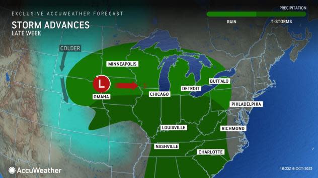

AccuWeather meteorologists say that the same storm set to bring some snow to the Rockies and severe thunderstorms to portions of the central Plains this week will pivot eastward across the Midwest and the Northeast with a dose of drenching rain.
The storm will have positive and negative impacts in the Midwest and mostly negative impacts for the Northeast.
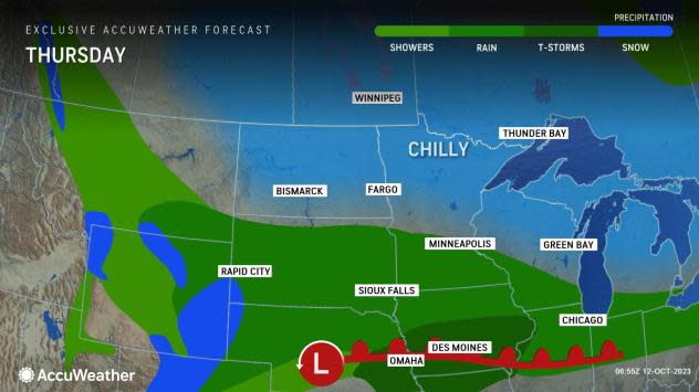
"The storm will first deposit several inches of snow on the higher terrain over the Rockies and can make for slippery and slushy conditions along a stretch of Interstate 80 in Nebraska and Wyoming on Thursday," AccuWeather Chief On-Air Meteorologist Bernie Rayno said.
 |
As the storm encounters warmer air farther to the east, thunderstorms will turn severe from eastern Nebraska to northeastern Kansas, northwestern Missouri and southwestern Iowa from later Thursday to Thursday night.
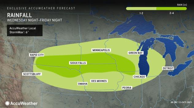
A drenching rain is in store north of the storm's track, mainly from just north of I-80 through I-90 and in part of the I-94 zone. The rain may last for 18-36 hours in some cases. Some of the rain will be heavy, but most of it will fall slowly enough to be absorbed by the dry ground. A general 2-4 inches of rain will likely fall with locally higher amounts.
 |
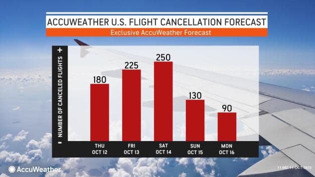
Cities such as Minneapolis, Chicago and Milwaukee should be prepared for delays on the roads and at the airports.
In urban areas, the combination of heavy rain and fallen leaves with blocked storm drains may be enough to trigger localized street flooding, AccuWeather Meteorologist Alyssa Glenny said.
The rain and leaf combo will make for slippery conditions as well.
 |
"Where the fall harvest has not been completed, the rainstorm may delay operations," Glenny said.
However, the rain will be largely welcomed in the drought-stricken region.
The landscape and watershed over much of the zone from the eastern part of the Dakotas and much of Nebraska to Ohio, Kentucky and portions of Michigan range from abnormally dry to extreme drought with pockets of exceptional drought -- the highest category, according to the United States Drought Monitor.
No doubt, a non-extreme rainstorm would be a boost for area reservoir and stream levels. A minor boost in water levels will occur on the Mississippi, Missouri and Ohio rivers several days to a couple of weeks after the storm departs. However, because of the drought conditions, much of the water will be absorbed with less runoff than if there were average or wet soil conditions. River levels will likely fall quickly after a potential several-foot temporary surge.
 |
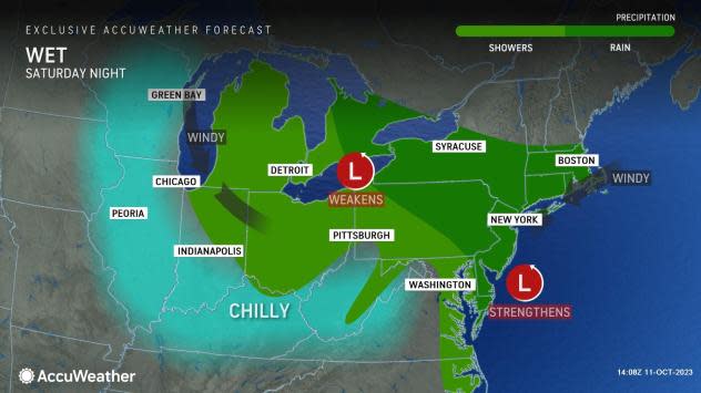
The thunderstorms will occur near and to the south and east of the storm's track as it moves through the Midwest from Thursday night to Saturday. Beyond Thursday night, widespread severe thunderstorms are not likely. However, a few of the storms that roll through areas from I-80 to I-64 in the Midwest can be locally heavy and gusty. As the storms approach area airports, some airline delays are possible.
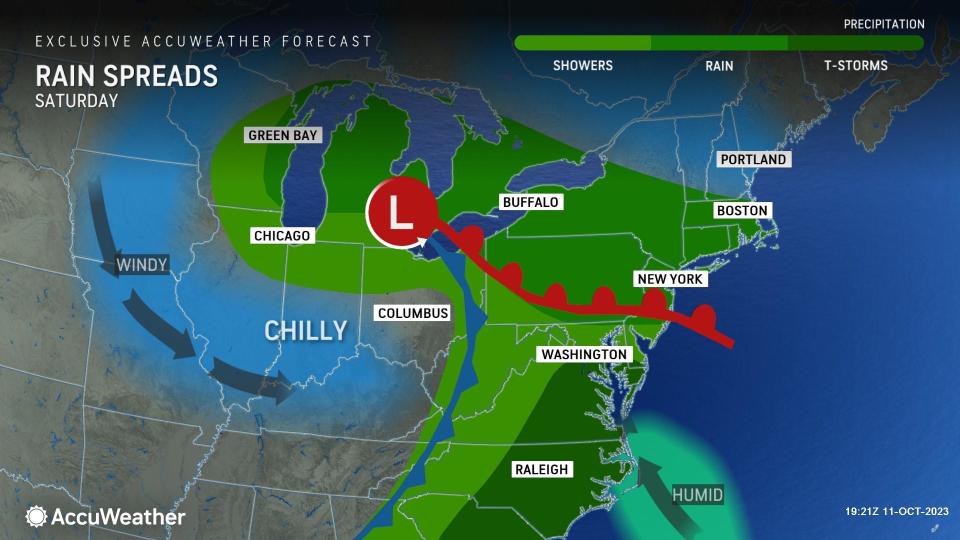
As the storm presses eastward, it will affect the Northeast over the weekend, which has become an all-too-familiar occurrence.
Rain will overspread portions of the central Appalachians and eastern Great Lakes region Friday, followed by the mid-Atlantic, the balance of New York state and southwestern New England during the day Saturday.
 |
In New York City, there has been rain for at least one weekend day for five weeks in a row, AccuWeather Senior Meteorologist Joe Lundberg said. If it rains this weekend, and there is every indication that it will rain both days this time, it will be six in a row.
The upcoming rainstorm is not likely to pack the same punch in terms of flooding that the most recent storms have from New York City to parts of New England. The storm during the last weekend of September was the most damaging and disruptive with over a month's worth of rain falling in a matter of hours. The Big Apple has been the wet apple since the start of September with 14.76 inches of rain falling, compared to a historical average of 5.62 inches, or 2.6 times the historical average.
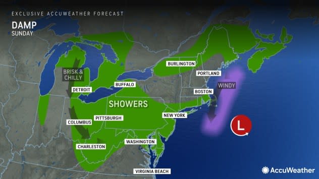
Enough rain will fall to bring a more typical risk of flooding in the Northeast's poor drainage areas this weekend. Like in the Midwest, where leaves have fallen, roads may be extra slick, and blocked storm drains may lead to localized street flooding.
 |
Low clouds, patchy fog and breezy conditions accompanying the storm, especially in the I-95 zone from Philadelphia to New York City and Boston, will likely lead to airline delays.
In the zone from near Washington, D.C., to Norfolk, Virginia, the rain is likely to be more showery and not as long-lasting, AccuWeather Senior Meteorologist Tyler Roys said.
"However, this zone, south of the storm track, is also a bit more likely to experience a thunderstorm," Roys said.
People with outdoor plans this weekend, such as attending a ballgame, wandering through a corn maze or hunting for the perfect pumpkin, can check the local AccuWeather MinuteCast for when there might be breaks in the rain.
AccuWeather RealFeel® Temperatures may be in the 40s to low 50s F as rain pours down and a breeze blows.
In the zone from the eastern Great Lakes to the central Appalachians and lower part of the mid-Atlantic coast, Sunday is likely to be the drier of the two weekend days, but cool winds are likely to kick up with the potential for a passing shower or two.
 |
It is possible that the steady rain departs the zone from Philadelphia to New York City to salvage a mainly dry afternoon on Sunday. This is provided the storm does not stall just off the coast.
A wedge of dry air may prevent rain from overspreading much of Maine, New Hampshire and northern Vermont. In this area, it is possible that both days of the weekend may be dry for leaf peepers hoping to glimpse colorful foliage. However, should the storm turn northeastward upon reaching the coast, the wet part of the weekend would be on Sunday in northern New England.
Want next-level safety, ad-free? Unlock advanced, hyperlocal severe weather alerts when you subscribe to Premium+ on the AccuWeather app. AccuWeather Alerts™ are prompted by our expert meteorologists who monitor and analyze dangerous weather risks 24/7 to keep you and your family safer.
