
Potent Northwest weekend storm prompts flood watches


AccuWeather meteorologists say that a damp and snowy pattern is gripping the Pacific Northwest through the remainder of the weekend. A storm advancing into Washington and Oregon has brought additional rainfall to locations that have either surpassed or are quickly approaching the typical monthly totals for December.
Flood watches were put in place through Sunday evening across northeastern Oregon into coastal Washington, warning of excessive runoff into rivers, creek and streams as a result of the persistent rainfall that spread across the region this weekend.
AccuWeather meteorologists highlighted that the heftiest rainfall totals were likely to occur across the upslope regions along the Coastal Range, where rainfall amounts ranged upwards of 3 inches. After recent rains that drenched the region last week, forecasters warned that these locations can be more sensitive to additional heavy rain and more susceptible to flooding, especially in low-lying and poor drainage areas.
Another notable factor that may enhance flooding throughout the day on Sunday can be the coastal tide levels. High tide is expected to run between 1-2 feet higher than earlier last week, which experts say may spell trouble for residents located near the mouths of coastal rivers.
 |
In Seattle, rainfall totals for December typically range around 5.72 inches. So far this December, rainfall totals have already exceeded that value as potent storms have repeatedly soaked the region since the month has kicked off.
Records from Portland, Oregon, show that the city is following a similar trend, with the 0.43 of an inch of rainfall from Saturday enough to push that city's monthly rainfall over the average rainfall total for December of 5.77 inches. Additional rainfall that spread across both cities on Sunday helped to place totals even higher above historical average rainfall levels for the month.
Looking back at last December, records show that both Seattle and Portland collected higher-than-average rainfall totals, ending the final month of 2022 with between 130-150% of their typical December rainfall values. Based on current trends, the cities may follow an identical course to last year.
Have the app? Unlock AccuWeather Alerts™ with Premium+
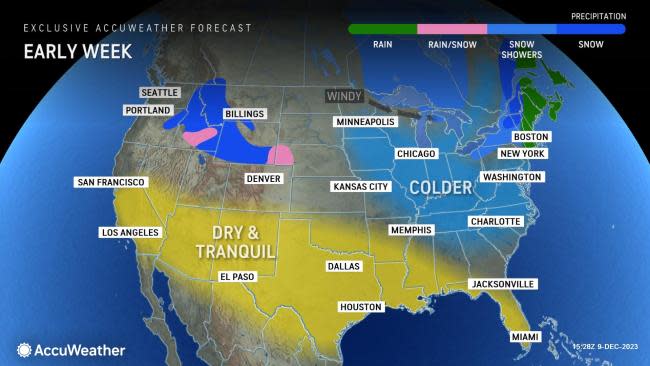
On Sunday, the chilly air across the Northwest helped to promote rounds of snowfall across the Cascades, Coastal Range and portions of the Northern Rocky Mountains. Snow levels dropped below pass level overnight Saturday, but have risen throughout the day on Sunday.
"Travel can be especially difficult for those departing the Seattle area into the mountains," explained AccuWeather Meteorologist Joseph Bauer. Through the highest elevations of the Washington Cascades, snowfall reports from Saturday night ranged between 12-18 inches.
In Snoqualmie Pass along Interstate 90, the Washington Department of Transportation advised vehicles to use traction tires for any travelers Sunday morning with oversized vehicles prohibited. Conditions across the passes are expected to gradually improve as rain spreads across the region on Sunday.
Slightly warmer conditions arrived across the region Sunday afternoon as temperatures rose anywhere between 8-12 degrees Fahrenheit compared to late last week. In Portland, Oregon, high temperatures are projected to climb into the lower 50s through Monday.
 |
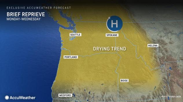
Forecasters say that a stretch of dry weather will kick off early this week, allowing a reprieve from the rounds of storms that has been plaguing the region.
From Monday to Wednesday, much of the Pacific Northwest will observe a drying trend as high pressure in the upper levels of the atmosphere promotes calmer conditions. This may give residents a chance to put up some last-minute outdoor holiday decorations, participate in any holiday festivities such as tree lighting ceremonies or just enjoy a dry start to the workweek.
By late Wednesday, chances will return for a weak feature to bring a quick shot of damp conditions to the Pacific Northwest.
Want next-level safety, ad-free? Unlock advanced, hyperlocal severe weather alerts when you subscribe to Premium+ on the AccuWeather app. AccuWeather Alerts™ are prompted by our expert meteorologists who monitor and analyze dangerous weather risks 24/7 to keep you and your family safer.
