
October or December? Unusual warmth to near record territory in Plains, Midwest
Temperatures are forecast to soar across much of the central and eastern United States through late week making it feel more like autumn rather than winter, but AccuWeather meteorologists say that people may still want to keep their winter coats within reach.
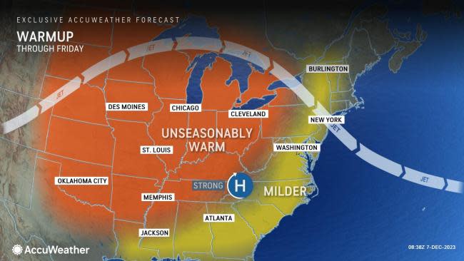
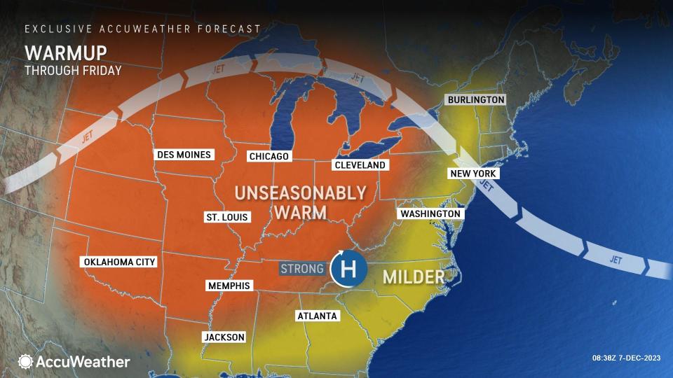
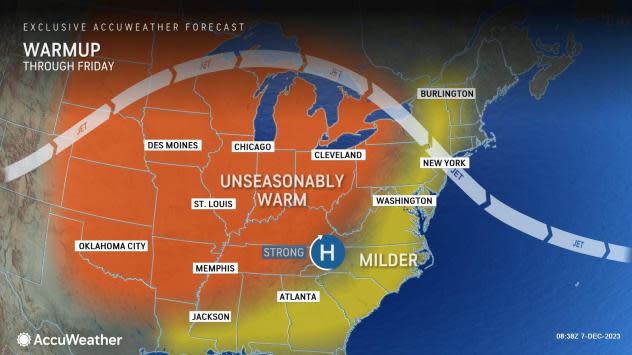
An area of high pressure combined with a northward bulge in the jet stream will usher in a warm spell from the northern Plains through the Midwest and eventually the Eastern Seaboard Thursday into Friday.
Across the northern Rockies and northern and central Plains, temperatures will surged 15-25 degrees above historical averages for early December on Wednesday. Cities including Bismarck, North Dakota, and Rapid City, South Dakota, reached the mid-60s which is more typical of late October.
The warmth mainly focused across the Plains and Midwest on Thursday. Temperatures across much of the region will soar to 10-20 degrees above historical averages into Friday.
Several locations, including Grand Forks, North Dakota; Omaha, Nebraska; and Eau Claire, Wisconsin, will come close to reaching record-breaking territory on Thursday. The temperature in Omaha, for example, is forecast to top out around the 60-degree mark on Thursday, which is a degree away from tying the daily record of 61 that was set back in 1918.
 |
The warmup will be delayed, but not denied, in the East. The surge of warmth is expected to start on Friday and continue into the weekend in many East Coast states.
A narrow band of snow developed on the leading edge of the warm air from the eastern Great Lakes to parts of the central Appalachians and the upper mid-Atlantic coast from Wednesday night to Thursday. Several inches of snow fell on part of western New York with up to 3 inches or so in part of southeastern Pennsylvania. Snow fell and generally melted in Philadelphia, Baltimore and New York City.
Multiple cities along the I-95 corridor including Washington, D.C., Philadelphia and New York City will have temperatures peak on Sunday with highs in the 60s, which is around 15 degrees above the historical average.
Those hoping to enjoy the mild conditions outside this weekend across the East will need to be cautious of wet and windy weather on Sunday as a large storm tracking into the Midwest and Great Lakes this weekend will spread steady rain, severe thunderstorms for some and gusty winds.
 |
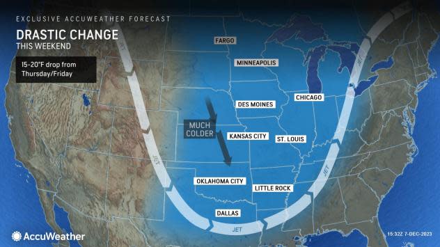
The unseasonable warmth won't last for long across the central and eastern U.S. as a drastic change in temperatures is expected this weekend into early next week.
A southward dip in the jet stream will usher in colder air from Canada across the Plains and Midwest, causing temperatures to drop 15-20 degrees from what was observed Thursday and Friday. The dip in the jet stream will reach the East early next week, bringing temperatures back down near historical averages for December.
Want next-level safety, ad-free? Unlock advanced, hyperlocal severe weather alerts when you subscribe to Premium+ on the AccuWeather app. AccuWeather Alerts™ are prompted by our expert meteorologists who monitor and analyze dangerous weather risks 24/7 to keep you and your family safer.
