
Midwest, Northeast Arctic outbreak and lake-effect snow to last days
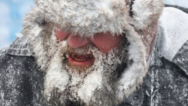
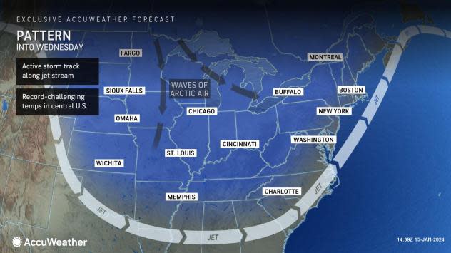
The coldest and most persistent outbreak of Arctic air in a couple of years will have the intensity and staying power to trigger feet of lake-effect snow and whiteouts in some areas of the Upper Midwest and the interior Northeast, AccuWeather meteorologists warn.
In the wake of a massive storm that affected more than 200 million people in the central and eastern United States with snow, rain, wind and thunderstorms to end the week, its impact on the weather will continue for many days. Its main role now is to help push Arctic air to the south and east, via gusty winds.
 |
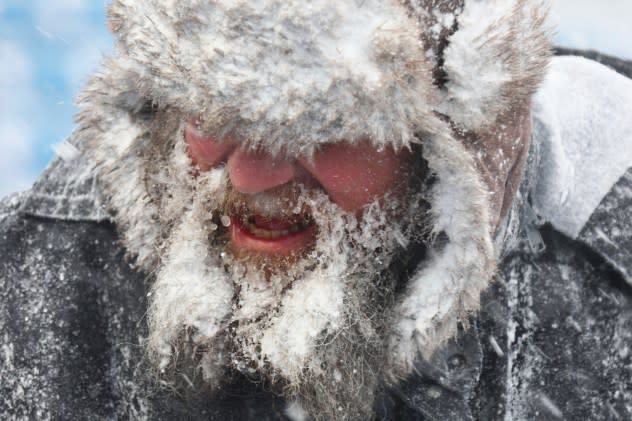
The frigid air, fresh snow and blowing and drifting snow in open areas over the Midwest will make the task of keeping roads and sidewalks clear difficult. As a result, travel may remain perilous. Motorists who become stuck or stranded in the snow or choose to walk will face subzero Fahrenheit AccuWeather RealFeel® Temperatures.
The Arctic air will advance eastward and southward in a few stages. One push already settled into the South Central states and advanced to the Atlantic coast this weekend. Another push will arrive in the wake of the storm on Tuesday night. A third push is likely this weekend following a storm to end the week.
Have the app? Unlock AccuWeather Alerts™ with Premium+
A push of Arctic air triggered snow showers and locally heavy snow squalls that advanced from the central and northern Appalachians to the mid-Atlantic and New England coasts on Sunday.
 |
Another opportunity for snow across the I-95 corridor will arise from Monday night to Tuesday as a Southern storm makes a run along the Atlantic coast.
As the frigid air passes over the relatively warm waters of the lakes, the moisture released will result in towering bands of clouds that can unleash tremendous amounts of snow on the downwind landscape. This lake-effect snow can result in highly variable weather conditions ranging from a clear sky to a blizzard in the span of less than a mile.
Depending on how long the bands of snow persist over a certain area, a tremendous amount of snow can fall. The snow bands can behave like intense summertime showers with thunder and lightning but with heavy snow instead of a torrential downpour.
 |
A worker helps remove snow from Highmark Stadium in Orchard Park, N.Y., Sunday Jan. 14, 2024. A potentially dangerous snowstorm that hit the Buffalo region on Saturday led the NFL to push back the Bills wild-card playoff game against the Pittsburgh Steelers from Sunday to Monday. New York Gov. Kathy Hochul and the NFL cited public safety concerns for the postponement, with up to 2 feet of snow projected to fall on the region over a 24- plus hour period. (AP Photo/ Jeffrey T. Barnes) |
"The complete lack of ice cover and water temperatures well above the historical average, combined with the brutal cold, will fuel extreme snowfall rates of 3-4 inches per hour," AccuWeather Senior Meteorologist Adam Douty said.
"Not only will lake-effect snow be measured by the feet downwind of the lakes into the start of the week, but several more feet of snow may also pile up from Tuesday through Wednesday, especially along some of the shores of Lakes Erie and Ontario. A very persistent west-southwest wind flow will be favorable to Buffalo, New York, and the South Towns, off of Lake Erie, and areas to the north of Watertown, New York, off Lake Ontario, to receive the heaviest snow from the long-lasting event, " Douty explained.
As of midday Monday, lake-effect snow during the outbreak has piled up to between 3 and 4 feet in the towns south of Buffalo, New York. In the city of Buffalo alone, snowfall through midday Monday ranged significantly from about 6 inches on the western side, near the Niagara River, to close to 2 feet on the southern side of the city.
"For much of the country, this will end up being the coldest and most persistent outbreak of Arctic air in a couple of winters," AccuWeather Senior Meteorologist Matt Benz said.
At its full extent, the frigid air will reach coastal areas of the Northwest, much of the Rockies, Plains, Midwest, South and Northeast states around mid-January.
 |
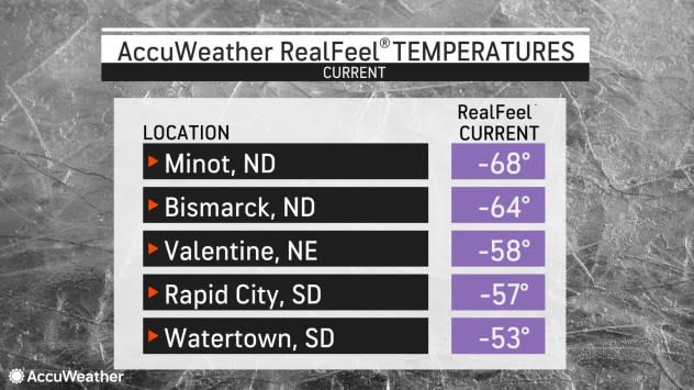
This image shows a sampling of AccuWeather RealFeel® Temperatures during the midday hours of Saturday, Jan. 13, 2024. |
Into midweek, nighttime lows around Chicago will range from the lower single digits to several degrees below zero F. In the East, New York City will have multiple nights with low temperatures well down into the 20s this week.
"You have to go back until February 2022 to find something about as cold and as lengthy as this outbreak will be, at least for the whole of the Central and Eastern states. The Northwest missed out on that cold air in 2022," Benz said.
The persistent cold winds will cause spray to freeze along the shores of the Great Lakes and lead to freezing overwash on the shorelines that face the winds. In some cases, such as on Lake Erie, a phenomenon known as a seiche will cause the lake to lean with high water on its northeastern end and low water on its southwestern end.
 |
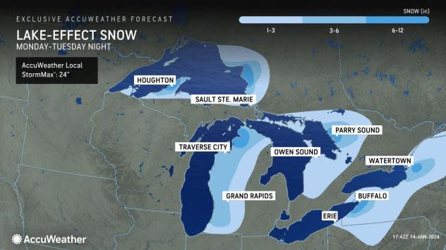
After easing down into Tuesday, bands of lake-effect snow are expected to ramp up once again Tuesday night and Wednesday as the East Coast storm pulls away. Many locations along the eastern shorelines of the Great Lakes will be able to pick up an additional 1-3 to 3-6 inches of snow, with some spots projected to get upwards of 6 inches.
Areas along the far northwest tip of Michigan, locations in and around Buffalo, New York, and east of Watertown, New York could be among some of the places to observe an additional 6-12 inches of snow, especially from Tuesday night to Wednesday. During this timeframe, the AccuWeather Local StormMax™ is 24 inches for lake-effect snow.
Want next-level safety, ad-free? Unlock advanced, hyperlocal severe weather alerts when you subscribe to Premium+ on the AccuWeather app. AccuWeather Alerts™ are prompted by our expert meteorologists who monitor and analyze dangerous weather risks 24/7 to keep you and your family safer.
