
Mid-December storm tours the southern US with snow, rain and wind


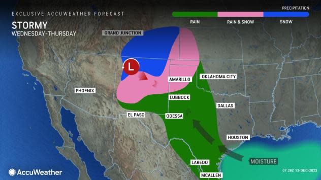
A storm that AccuWeather meteorologists have been monitoring for over a week has begun over the southern Rockies. The storm has the potential to unload 1-2 feet of snow in parts of Colorado and New Mexico with locally higher amounts at some ski resorts before spreading much-needed rain across Texas and bringing problematic conditions into Florida.
The storm and its snow are likely to cause major travel problems along a portion of the Interstate-25 corridor while soaking rain and thunderstorms could trigger sporadic flash flooding in parts of Texas.
The jet stream dove toward the interior Southwest earlier this week before carving out a storm system that pulled in moisture from the Gulf of Mexico into Wednesday. Areas of rain then developed in southern and western Texas, western Oklahoma and southwestern Kansas as snow broke out over the mountains in southern and central Colorado and northern New Mexico.
 |
"Much-needed rain will fall on portions of the southern Plains, and this will evolve into a decent snowstorm for a number of mountain ranges that make up the southern Rockies," AccuWeather Senior Meteorologist Adam Douty said.
"Some of the mountains in northern New Mexico and southern Colorado may pick up upwards of 12 and perhaps 18 inches of snow from Wednesday to Thursday night," AccuWeather Senior Meteorologist Matt Benz said. Snow will also spill onto parts of the High Plains of northwestern Texas and western Oklahoma, southwestern Kansas and central New Mexico from Thursday night to Friday, he added.
 |
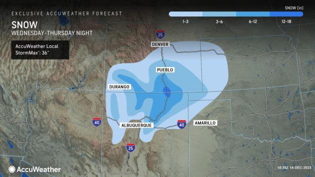
The AccuWeather Local StormMax™ snowfall of 36 inches is most likely to occur over the ridges and peaks in south-central Colorado and north-central New Mexico.
Travel will become slow and difficult along the stretch of I-25 from Albuquerque, New Mexico, to Pueblo, Colorado, into Thursday. There is the risk of road closures over the high ground, especially in northeastern New Mexico.
A period or two of snow will extend well to the north along I-70 in central and eastern Colorado and western Kansas. Several inches of snow will be possible in southeastern Colorado and southwestern Kansas. A few pockets of freezing rain are also likely over the southern High Plains as well.
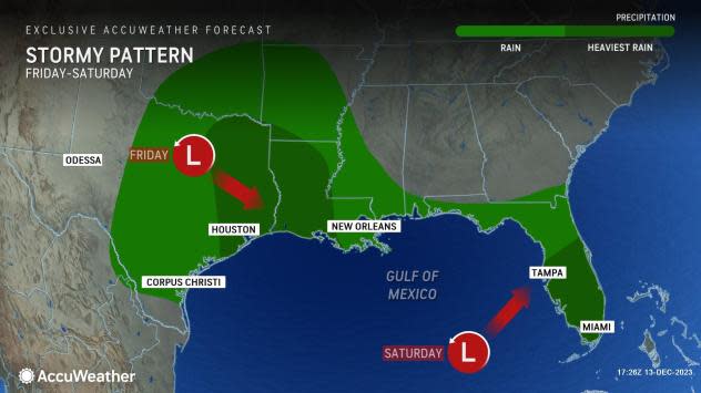
Farther to the east, areas of rain will develop from southeastern Texas to much of Florida and coastal areas in between along I-10 late this week and this weekend.
 |
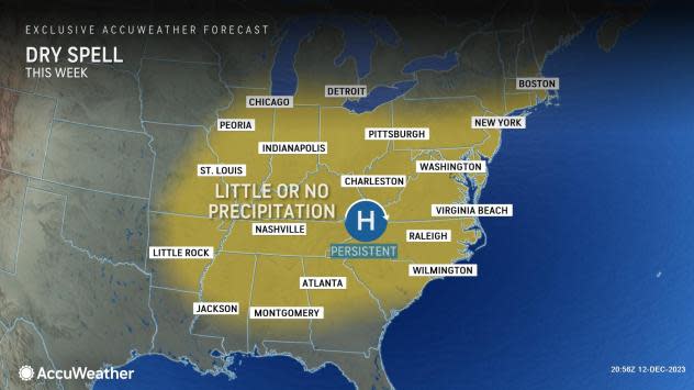
Meanwhile, a strong area of high pressure will build from the Midwest to the mid-Atlantic region this week. This high-pressure area will tend to keep the storm and much of its rain pent up near the Gulf of Mexico, Benz explained.
In a bit of a change since earlier this week, a period of drenching rain will push northward into much of northeastern Texas and northern Louisiana from Friday to Saturday, where significant drought continues in some locations. Areas of severe to exceptional drought conditions continue over much of the South Central and Southeast states, according to the United States Drought Monitor report issued last week. Thunder may accompany the rain, but severe weather is not anticipated until the weekend, when a zone extending from the Florida Peninsula through the South Carolina coastline will be in line for potentially damaging thunderstorms.
 |
No rain or thunderstorms will occur through Saturday over areas hit the hardest by tornadoes this past weekend in the zone from near I-20 to I-64, which is good news for Tennessee communities cleaning up after the storms. The most likely zone for heavy, gusty and locally severe thunderstorms will be south of the storm as it tracks through the East.
The difference in pressure between the high and the storm (low pressure) will create stiff east-to-northeast winds averaging 15-25 mph with gusts from 30-40 mph likely along the Gulf coast, and especially along Florida's Atlantic coast, spanning several days through Saturday.
Into this weekend, the persistent winds will raise tide levels, cause rough surf and strong rip currents and may lead to beach erosion along Florida's east coast. Because of the duration of the event, water will pile up along the east-facing shoreline areas and will build on the back bays and tidal rivers.
Rounds of rain across much of Florida look most certain later this week, especially in the southern half of the peninsula, as moisture from the Gulf storm arrives and perhaps tropical moisture from the Caribbean, AccuWeather Senior Meteorologist Courtney Travis said.
"There is a slight chance the storm will acquire some tropical characteristics because of the time it spends over the warm waters of the Gulf of Mexico and just off the southern Atlantic coast," AccuWeather Director of Forecasting Operations Dan DePodwin said.
There is a potential for excess rainfall in southeastern Florida, potentially even rivaling the rain that fell back in November. The same storm is likely to turn northward and move up the Atlantic coast next week with drenching rain and gusty winds.
Because the storm is forecast to track so far to the south in the Southern states this week, severe weather is likely to be very limited until the storm starts to move northward along the Atlantic coast.
Want next-level safety, ad-free? Unlock advanced, hyperlocal severe weather alerts when you subscribe to Premium+ on the AccuWeather app. AccuWeather Alerts™ are prompted by our expert meteorologists who monitor and analyze dangerous weather risks 24/7 to keep you and your family safer.
