
Storm dishing wintry weather to parts of Midwest, Northeast


A storm affecting the Midwest and Northeast during the latter part of the weekend could have people swapping their umbrellas for snow shovels, AccuWeather meteorologists say.
The system tracking over the Midwest and Northeast as December got underway produced a few pockets of snow, but it was not quite cold enough across the regions for widespread wintry precipitation.
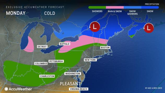
"The storm expected through Monday across the Great Lakes and Northeast will feature a damp and dreary rain for most of the coastal Northeast," AccuWeather Meteorologist Brandon Buckingham said. The combination of rain, low clouds and fog will make for slick conditions and poor visibility at times, leading to slow highway travel and airline delays in Chicago, New York City, Washington, D.C., and other major cities.
 |
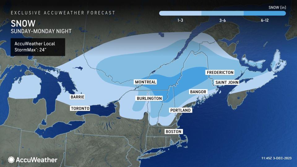
Colder air will seep southward into Monday morning, setting the stage for snow to continue falling in parts of upstate New York and northern New England with a wintry mix farther south in New York and central New England.
In the higher elevations of the northern Green and White Mountains and across central and northern Maine, there is the potential for 6-12 inches of snow to fall, with locally higher amounts over the ridges and peaks. There is an AccuWeather Local StormMax™ of 24 inches.
 |
Between 1 to 3 inches of snow is likely with a mixture of sleet and rain from east-central New York to southern Vermont, New Hampshire and close to the Maine coast. There is a small risk of a slushy accumulation a bit farther to the south in New York and into northern areas of central and western Massachusetts.
"Temperatures will likely hover within a few degrees of freezing across places like the Champlain and Connecticut valleys of northern New England," Buckingham said, adding, "This could limit the amount of snow that falls to a few inches, but if temperatures dip lower than expected, more snow could pile up."
In the wake of the large storm, conditions during the first half of the new week will feature temperatures near to slightly below the historical average in the Midwest and Northeast, with a round or two of rain and snow showers expected as an Alberta Clipper system moves across the region by midweek.
Want next-level safety, ad-free? Unlock advanced, hyperlocal severe weather alerts when you subscribe to Premium+ on the AccuWeather app. AccuWeather Alerts™ are prompted by our expert meteorologists who monitor and analyze dangerous weather risks 24/7 to keep you and your family safer.
