
Scientists identify main source that could be fueling Iceland’s hotbed of volcanic activity
Sign up for CNN’s Wonder Theory science newsletter. Explore the universe with news on fascinating discoveries, scientific advancements and more.
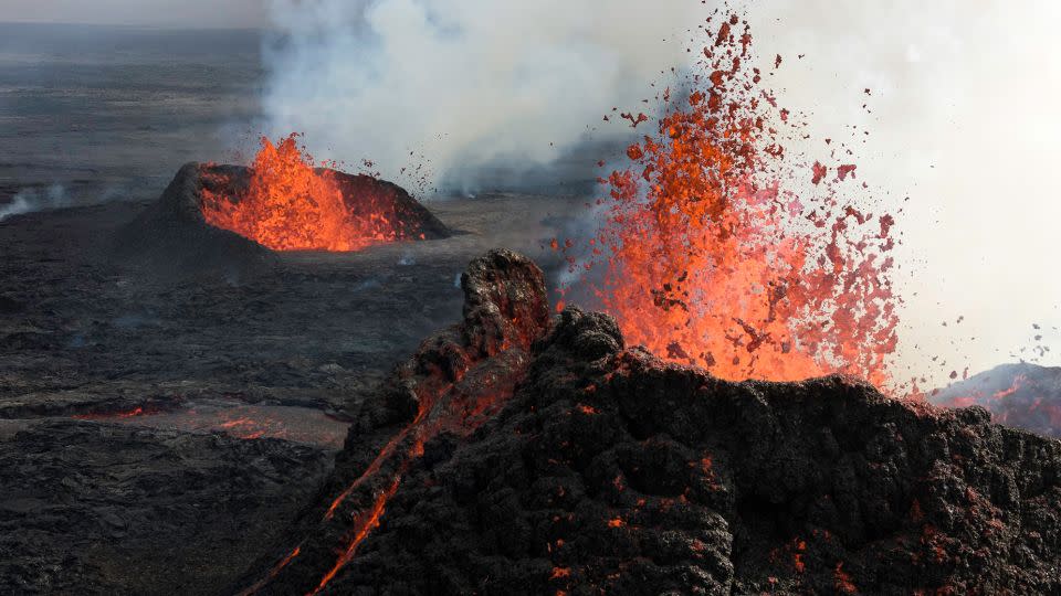
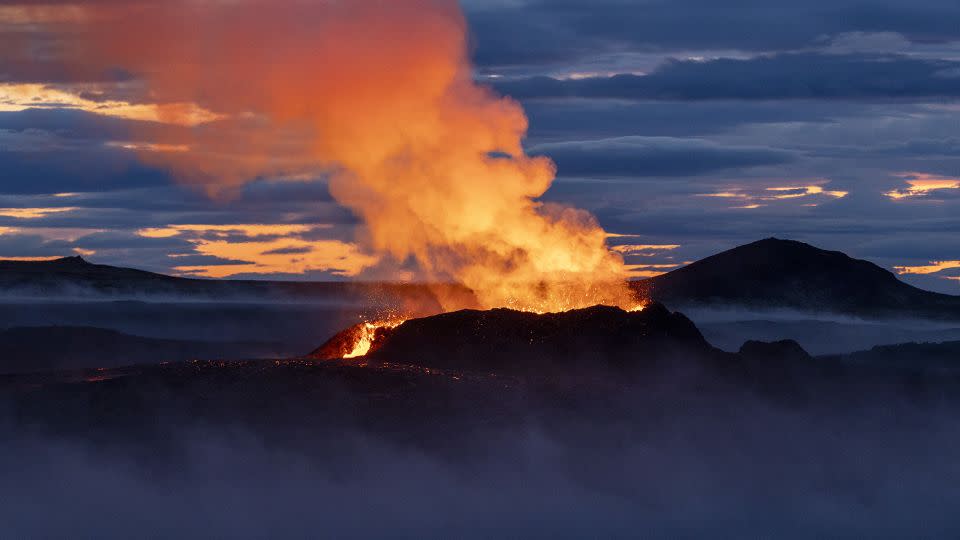
After 800 years of calm, volcanoes have awakened in the Reykjanes Peninsula of Iceland — about 56 kilometers (35 miles) south of the nation’s capital, Reykjavik.
Since 2021, a string of eruptions has disrupted everyday life in the densely populated area, leading to evacuations, power cuts and infrastructure damage, as well as stoking fears of an event like the eruption of Eyjafjallajökull, a large volcano about 80.5 kilometers (50 miles) to the southwest that caused an international travel crisis in April 2010.
While there is no risk of a global calamity happening, researchers are now warning that new scientific evidence suggests the eruptions originating from the Reykjanes Peninsula could continue for years or even decades. The prolonged volcanic activity could lead to more disruption and potentially force the long-term evacuation of Grindavík, a fishing town of over 3,000 residents that’s also the gateway to Iceland’s biggest tourist attraction — the Blue Lagoon geothermal pool.
“I think we need to get ready for giving up Grindavík,” said Valentin Troll, a professor at the department of Earth sciences of Uppsala University in Sweden, and lead author of a study on the eruptions, published Wednesday in the journal Terra Nova.
“It can still survive as a fishing port, with people going in and out. But people staying there, with the possibility of a very rapid onset of volcanic activity, I don’t think that’s recommended. What we think right now is that the eruptions will likely continue as we have seen over the last three years, and our results would support that.”
To be able to predict whether the eruptions would continue and how future volcanic activity might play out, Troll and his fellow researchers took a fresh approach by bringing together two separate branches of science that revealed a primary underground source of magma, or molten rock, fueling activity in the Reykjanes Peninsula.
Hugh Tuffen, reader in volcanology at Lancaster University in the United Kingdom who was not involved in the report, said the research made a solid case for the frequency of eruptions in the coming years. “This study provides a useful synthesis of evidence from the history of eruptions on the Reykjanes peninsula, the chemistry of the erupted lavas and the depth and nature of earthquakes,” he said.
“The evidence all points to the establishment of a single magma reservoir beneath (the volcano) Fagradalsfjall, and that this reservoir can then feed eruptions at different positions on the Reykjanes peninsula, depending on the shifting stresses in the crust.”
A new age of volcanic eruptions in Iceland
Iceland, which is roughly the size of Kentucky with a population of nearly 400,000, boasts more than 30 active volcanoes that have become tourist attractions within the country’s breathtaking scenery.
The high number of volcanoes that are either actively erupting or indicating signs of disquiet is due to the fact that the island sits on a boundary between tectonic plates (gigantic slowly moving pieces of the Earth’s crust and uppermost mantle), Troll explained, creating cracks that allow magma to come up.
“The Reykjanes peninsula is exactly on this plate boundary,” he added, “and it seems that we are now witnessing the earliest part of a major eruption episode. That’s a recurrent phenomenon on the peninsula, with 800 years of pause or quiescence, followed by 100 or 200 years of intense eruptions, followed by another quiet period. Scientifically, we are lucky to be able to observe this, but from a societal point of view we are not, because it happens in a very populated part of the country with a lot of infrastructure.”
There is now a vast barrier system in place around Grindavík to protect the town, with lava pushing against it in many places, Troll said. A power plant is also in the area, and it supplies Keflavík International Airport, the country’s main airfield that’s perched at the tip of the peninsula. “If the power plant is affected, we might have energy shortages at Keflavík airport in the long run. This could then have an effect on international travel,” Troll said.
However, he added, the probability of an Eyjafjallajökull-style event is rather slim, because the situation in the Reykjanes Peninsula is different — the lava fields are shallow, and the eruptions in the past three years were not remotely close to the levels of Eyjafjallajökull.
Key magma resevoir revealed
The research team looked at the issue from the standpoint of geochemistry and geophysics.
First, the team used geochemistry to look at the composition of the lava and recognized a similarity between samples taken several miles apart. This finding shows that the eruptions are all fueled by a shared magma reservoir that sits 9 to 12 kilometers (5.6 to 7.5 miles) below the surface, rather than different sources.
Then, the scientists used geophysics to look at the distribution of a series of earthquakes connected to the eruptions, and found a cluster of deep seismicity at exactly the same depth underground. “It’s straight under a volcano called Fagradalsfjall, and that seems to be the main magma chamber or macro reservoir, supplying other volcanoes as well,” Troll said.
“That’s good news, in a way, because it means that we will have individual, smaller eruptions likely going on for some time, but not many simultaneous eruptions along the entire peninsula,” he explained.
The combined use of geochemistry and geophysics is not frequent, but can lead to educated guesses on how many eruptions can come from a volcano, according to Troll.
“The strength of this study and what makes it really powerful is that we’re combining two fundamentally independent methodologies to come up with very similar conclusions,” he said.
“Geochemistry says the magma is of the same source, and seismic tomography says there’s only one main reservoir at depth. Putting these two things together gives quite some strength to our prediction.”
Seismic tomography is a process that tracks and analyzes patterns of seismic waves generated by earthquakes in order to detect and characterize Earth’s interior features as three-dimensional models.
Monitoring seismic activity
The study is interesting and the results are convincing, said volcanologist Einat Lev, an associate research professor at the Lamont-Doherty Earth Observatory at Columbia University in New York.
“I think it’s great to see geophysics and geochemistry being used in synergy to answer important questions about the Earth,” said Lev, who was not involved in the study. “The volcanology community understands that cross-disciplinary collaborations are critical, and it is definitely a direction we are working towards.”
She added that the eruptions may indeed threaten Grindavík. “We have seen already that even if magma doesn’t erupt or if the lava doesn’t flow towards the town, ground inflation and deflations as well as the cracks they create threaten the stability and safety of Grindavik’s infrastructure.”
Combining different types of evidence, such as geochemical information about the lava and geophysical data from the earthquakes, is fairly novel and it’s exciting that they both agree, said Jessica Johnson, an associate professor of geophysics at the University of East Anglia in the United Kingdom, who also did not participate in the work.
Demonstrating that the magma is being supplied from a shared reservoir has implications for the frequency of eruptions and how long they will go on for, she added.
“It means there is a large supply of magma that is easy to erupt, allowing eruptions to happen in the region for a long time to come,” Johnson explained.
“Unfortunately, as the storage region is quite large, it means that it is harder to say exactly where the next eruption will be. That is why everyone in the area needs to be prepared for ongoing eruptions.”
According to Tuffen of Lancaster University, the study emphasizes the importance of ongoing monitoring efforts. Icelandic geoscientists and international collaborators are tracking the frequency and intensity of seismic activity and ground deformation in real time. The approach allows them to rapidly assess the likelihood of future eruptions as magma amasses in Earth’s crust and new pathways unfold.
For more CNN news and newsletters create an account at CNN.com

