
Who's hot, who's not for the Fourth of July 2024

When July rolls around it is hard-pressed to find much cool air across the United States, and the heat in some areas today may be so extreme that it poses health risks for millions celebrating Independence Day, AccuWeather meteorologists caution.
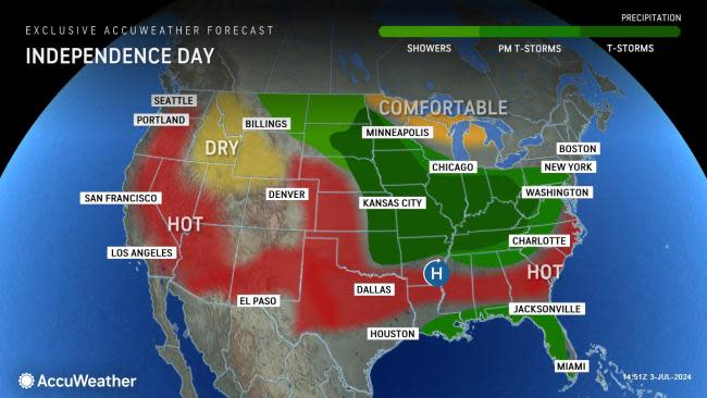
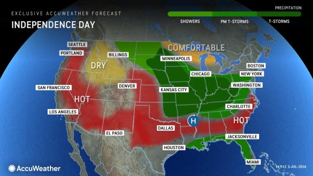
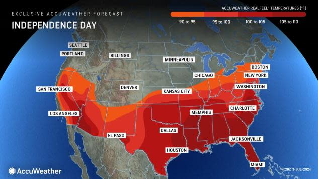
For portions of the southern Atlantic and Gulf coasts, as well as the central and southern Plains, the heat may seem typical for the middle of the summer, but in reality, will generally range from 5-10 degrees above the historical average.
For example, Dallas can expect triple-digit heat compared to a typical high in the mid-90s. It'll be a similar story in Atlanta, where the historical average high is about 90, but temperatures are forecast to reach the mid-90s. Throw in high humidity and AccuWeather RealFeel® Temperatures will soar above 100 for several hours during the afternoon.
 |
However, the extreme heat will be over the interior West on July Fourth, where highs in the 100s will be widespread, except for the mountains. In much of interior California, western Arizona and southern Nevada, high temperatures will range from 10-20 degrees above the historical average, which is already too hot for millions of Americans to handle.
In much of the mid-Atlantic and Northeast, as well as the Midwest, northern Plains and Northwest, the heat will be more in line with July standards. Still, in some of the big cities along Interstate 95, temperatures will push above the historical average by a few degrees, reaching the upper 80s to the lower 90s. Higher humidity levels in the Midwest and East will cause the comfort index to decline.
 |
In terms of dry versus rainy weather, most locations across the nation will not experience rain but only brief showers or thunderstorms, so most of the day will be free of rain. However, there will be a large trouble zone centered on the Midwest.
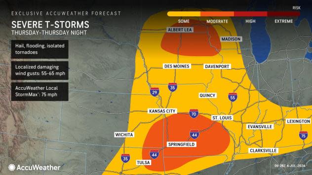
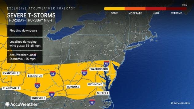
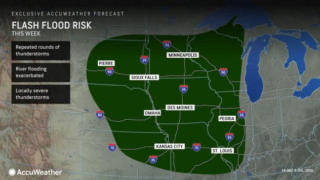
The area from the northern Plains to the mid-Mississippi and Ohio valleys can expect clouds to dominate with the likelihood of multiple showers and thunderstorms. Some of the storms are likely to be severe with the risk of damaging wind gusts, hail, torrential downpours and even an isolated tornado.
 |
Farther to the east, places from Kentucky to Virginia, Maryland and Delaware can also expect thunderstorms. A few thunderstorms are likely throughout the day, but they will become more numerous during the afternoon and evening, especially in the east.
Any thunderstorm from the Ohio Valley to the lower part of the mid-Atlantic region can bring a quick and heavy downpour as well as localized damaging wind gusts.
 |
A key takeaway is that a thunderstorm need not be severe to pose a risk from a sudden lightning strike. For this reason people are urged to monitor weather conditions closely when clouds seem to be billowing in the region. To be ultra-safe, move indoors, away from windows, at the first rumble of thunder.
The downpours in store for parts of the Plains and Midwest may add enough water to saturated ground to lead to incidents of flash flooding and aggravate ongoing river flooding.
 |
Motorists are urged to avoid driving through flooded roadways, as the pavement beneath may have been washed away, the water may be too deep for their vehicle, or water levels may be rising quickly during the crossing.
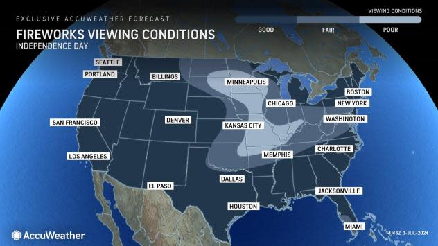
As far as viewing conditions for fireworks, most areas will have little to no trouble Thursday evening, except for parts of the Plains and Midwest, where storms are in the forecast.
 |
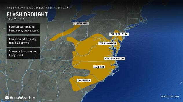
However, tinder-dry conditions exist in parts of the West, southern Plains and East, which may restrict the personal use of fireworks and campfires. AccuWeather Senior Meteorologist Bill Deger said a flash drought is underway in parts of the mid-Atlantic.
"In Virginia, officials have asked residents and visitors to attend public displays in lieu of using their own fireworks for entertainment due to the severity of the dry brush," Deger stated.
 |
The cool spots across the nation will be right on most beaches where downpours persist, and along the northern tier of the Northwest, Midwest and Northeast. Highs in the northern tier will generally be in the 70s to the lower 80s on Independence Day.
Keep in mind that water temperatures typically do not reach their peak along much of the U.S. shoreline until the middle to late part of August. Temperatures in the surf zone can fluctuate daily due to the action of breezes, upwelling and small swirls of water, known as eddies.
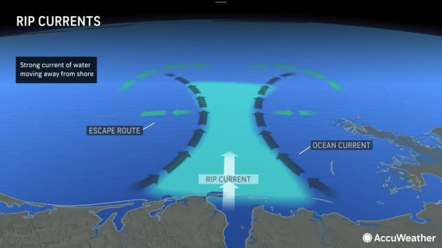
For those seeking the beaches to cool off, only swim in lifeguard-monitored areas. Changing tides can cause rip currents to shift and fluctuate from one part of the day to the next, and they have proven to be deadly so far this season.
 |
Rip currents often exist where wave action seems to be reduced relative to the rest of the surf zone. If caught in a rip current, experts urge not to panic and swim parallel to shore, even if being carried into deep water. Soon, the current will ease, allowing the person to swim back to shallow water.
Above all, it is highly recommended to heed beach safety signs. In some cases, particular beaches may be closed due to rough surf, underwater hazards, algae and high bacteria levels.
Want next-level safety, ad-free? Unlock advanced, hyperlocal severe weather alerts when you subscribe to Premium+ on the AccuWeather app. AccuWeather Alerts™ are prompted by our expert meteorologists who monitor and analyze dangerous weather risks 24/7 to keep you and your family safer.
