
US to get walloped with coast-to-coast winter storm this week
Large parts of the United States will be walloped by a historic, late winter storm in the coming days with possible record snowfall in some places.
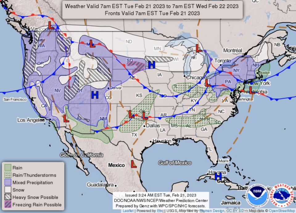
Up to two feet of snow is possible in parts of the midwest, particularly across southern Minnesota, and a high chance of more than eight inches from South Dakota east through Minnesota, Wisconsin and Michigan.
The snowfall will be accompanied by bitterly cold temperatures and treacherous blizzard conditions. The National Weather Service (NWS) for Minneapolis-St Paul was warning of “life-threatening travel conditions” late Wednesday and into Thursday, and power outages were also possible.
In the US West, one to two feet of snow is expected at higher elevations in mountain ranges while flurries mixed with rain will impact interior valleys.
Moderate to heavy rain, as well as thunderstorms, were forecast along the Pacific Northwest on Tuesday. As temperatures drop overnight, there is possibly of light snow in central California valleys on Wednesday.
Snow had already begun to fall across stretches of the plains on Tuesday and by Thursday, much of central New England will see snow streaming in. More than 12 inches of snow is likely for high elevations in the Adirondacks and the Green and White Mountains, with lighter accumulations of up to four inches across upstate New York and central New England.
Freezing rain or sleety conditions will drive across southern New England before easing off by Friday.
Aside from the snowfall, there is a slight risk of excessive rainfall from northeast Missouri into northern Illinois, northern Indiana, and southern Michigan and some spots of flash flooding.
Parts of the west and High Plains will experience very strong winds of 50-60 mph, and as high as 80 mph in some locations. An elevated risk of fire weather is forecast to continue for the southern High Plains through Wednesday.
Beside the glut of precarious weather conditions, there will be wide variations in February temperatures.
Many record-tying or record-breaking highs can be expected particularly for the Ohio and Tennessee valleys, where temperatures will climb above 70 degrees Fahrenheit. Closer to the Gulf Coast and Florida, highs will soar into the 80s.
On the flipside, record lows will be possible in the west, with temperatures in the 30s and 40s for the Pacific Northwest and 50s in California. Bitterly cold wind chills, some 20-30 degrees below zero, are expected for the Northern Plains.

