
UK weather: Four-day heat health alert comes into force today - as forecasters reveal warmest day this week
A yellow heat health alert comes into force for most of England today, as temperatures are set to hit 31C in parts of the country.
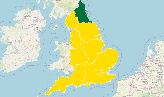
The notification, covering all but one region of the country, highlights the risk of increased pressure on healthcare services as a result of the forecast mini-heatwave.
The alert, issued jointly by the UK Health Security Agency (UKHSA) and Met Office, comes into force from 8am and remains in place until 5pm on Thursday.
Temperatures are expected to spike at 31C (87F) in parts over the coming days, with "many places" due to see the thermometer reach the mid-20Cs (77F).
The Met Office says in some areas there is the likelihood of a heatwave - which occurs when temperatures go above a set threshold for three days in a row.
See the latest weather forecast where you are
The strongest warnings have been given for the East Midlands, the East of England, East Anglia and the South East with the "potential for significant impacts to be observed across the health and social care sector due to the high temperatures".
These include an "observed increase in mortality across the population likely, particularly in the 65+ age group or those with health conditions, but impacts may also be seen in younger age groups", the UKHSA said.
For the North West and North East of England, the West of England, the South West and London, there is an "increase in risk of mortality amongst vulnerable individuals and increased potential for indoor environments to become very warm", the alerts warn.
The heat health alert service covers England only, with colours including green (meaning no alert is issued); yellow (meaning a response is required); amber (an enhanced response is required); and red (an emergency response) which would indicate a significant risk to life.
Liam Eslick, a meteorologist at the Met Office, said Monday would see mostly dry weather with "plenty of sunny spells" and a maximum temperature of 28C (82F).
On Tuesday, conditions are expected to become cloudy and murky in western Scotland and Northern Ireland. Some showers will be seen across northern England which could turn thundery, but the rest of the country will see "more sunshine" and temperatures up in the mid to high 20Cs.
The forecaster said Wednesday is likely to be the warmest of the days so far with highs of 30C (86F) in the South East.
Temperatures on Thursday are expected to remain "widely warm" with some areas seeing highs of up to 31C.
Hotter spells will be fleeting
The upcoming hot spell marks a break from the rainy spring, which saw 32% more rainfall than the average in England and Wales, making it the fifth wettest for England and the eighth wettest recorded for Wales, according to the Met Office.
However, the heat is only expected to last until midweek, giving way to showers, thunderstorms and persistent rain.
The wet weather has been coming from the Atlantic and a high-pressure system is expected to halt it for a few days.
Met Office operational meteorologist Honor Criswick said: "As we're pushing into next week, we're starting to see the hotter spells, but it is going to be quite brief."
Read more:
Popular sunscreens fail safety test
How hot is too hot for human body to function?
Over 1,000 die during Hajj as heatwaves spread across world
Despite the wet weather, it has been the warmest May and spring ever recorded in the UK.
The average temperature has been 13.1C, beating the previous 2008 record of 12.1C.
Dan Rudman, Met Office deputy chief meteorologist, said: "Whether or not everyone experiences heatwave thresholds, the majority of the UK will experience the highest temperatures so far this year.
"Confidence in the forecast reduces markedly from Wednesday onwards, with uncertainty in both how long the heat will last and how it will break down, which we will be keeping an eye on for the coming days.
"However, by next weekend, cooler, changeable conditions become more likely."

