
Tropical threat may arise in Caribbean days after hurricane season begins


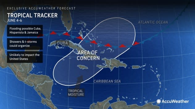

June 1 marks the official start of the Atlantic hurricane season, and there is a zone AccuWeather meteorologists are already watching for tropical development. The area extends from part of the northern Caribbean across the central islands of the Caribbean and into the southwestern Atlantic.
"The area of interest we are looking at may not evolve until well into the first week of June -- the period from June 4-6 to be exact," AccuWeather Lead Hurricane Meteorologist Alex DaSilva said.
 |
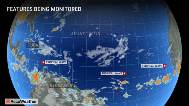
As of the start of the week, this area was already active with a band of clouds, showers and thunderstorms. A disturbance, known as a tropical wave, was interacting with the moisture and has been enhancing the activity just a bit. However, it was far from showing any signs of tropical development and not likely to do so for several more days at the very least.
"Later during the first week of June, a disturbance in the middle part of the atmosphere will move across the eastern part of the Gulf of Mexico and may interact with that tropical moisture zone," AccuWeather Lead Long-Range Meteorologist Paul Pastelok said. "There is a remote chance it could initiate a tropical depression or more in this area."
 |
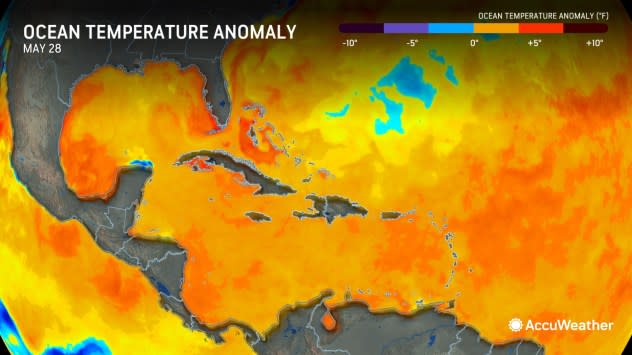
Part of this zone, along with an area along the southern Atlantic coast of the United States, experienced some cooling of water temperatures earlier this spring.
"The cooling trend in that area has now reversed," Pastelok said.
Much of the Atlantic was experiencing record or near-record high sea surface temperatures this past winter and spring.
Warm water and moisture do not make tropical development a lock, however.
"Indications are that the system may fight with stiff breezes, known as wind shear, and the proximity of a front," DaSilva said.
 |
The steady or shifting breezes associated with wind shear can disrupt an organized tropical system or prevent it from developing. The warm and cool clash of air associated with a front is another deterrent, as tropical systems need a uniformly warm environment to form. Anything to the contrary results in a non-tropical or subtropical storm.
Should wind shear drop off or the system detach from the front, it could slowly develop tropically. DaSilva said, "Water temperatures are not super warm in the region northeast of the Bahamas, but they are warm enough to support a tropical system."
The critical temperature for tropical development is about 80 F.
Should the system overcome the obstacles, it would be the first tropical depression and storm of the year. Alberto is the first name on the list for the 2024 Atlantic season.
Since the winter, AccuWeather meteorologists have anticipated a super-charged hurricane season with many tropical storms and hurricanes. Their team has raised concerns about multiple threats to the United States and the likelihood that some storms may rapidly intensify as they approach land, adding to the danger.
 |
"Even if this system fails to develop into a tropical depression or storm, it will deliver a substantial amount of rain on Hispaniola and some of the other islands in the northern Caribbean in the coming days," DaSilva said.
Should the system develop, it would not pose any threat to the U.S., as steering breezes would take it to the northeast of the southern Bahamas and the Turks and Caicos and into the central Atlantic.
Want next-level safety, ad-free? Unlock advanced, hyperlocal severe weather alerts when you subscribe to Premium+ on the AccuWeather app. AccuWeather Alerts™ are prompted by our expert meteorologists who monitor and analyze dangerous weather risks 24/7 to keep you and your family safer.
