
Temperatures to soar across the Midwest, Northeast this week

A shift in the weather pattern for millions from the nation's heartland to the East Coast this week will result in a big jump in temperature and an enhanced risk for brush fires due to a prolonged dry stretch, AccuWeather meteorologists warn.
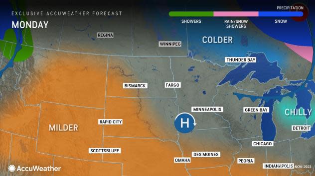
The prospects of warmer weather, driven by a shift in the jet stream to the north, will stand in stark contrast to the chilly conditions expected across the region this weekend and early this week. It will also be a mirror image of the stormy and cool pattern forecast to envelop the West later in the week.
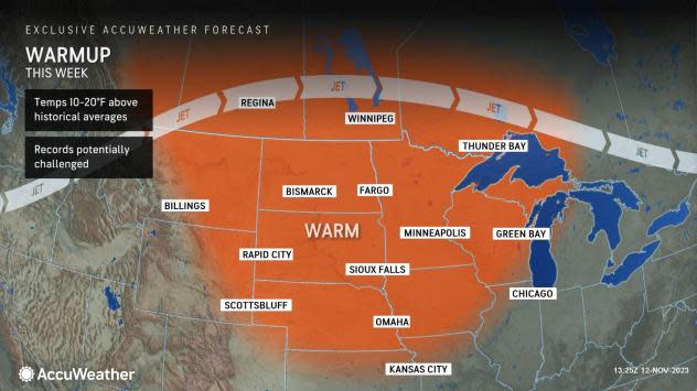
The warmth, with temperatures in some areas forecast to be up to 20 degrees above the historical average and to challenge records, will be great for those looking for some more time outdoors ahead of the cold months ahead, forecasters say. It will also be accompanied by rounds of dry winds, complicating efforts to fight ongoing brush fires and threatening to ignite more, amid autumn's dry, fallen leaves.
 |
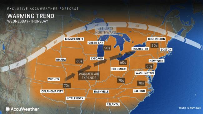
Following a period of cool weather into the weekend, the first part of the country to experience a warming trend this week will be the middle of the country, from the Plains to the Midwest, AccuWeather meteorologists say.
"A dome of high pressure is expected to set up shop across a wide swath of the central U.S. this week," said AccuWeather Meteorologist Brandon Buckingham. "This will promote above-average warmth and largely dry conditions."
That warmer weather has made its presence felt, as temperatures in places such as Fargo, North Dakota, and Omaha, Nebraska, jumped by 5-10 degrees from Saturday to Sunday. Typically, high temperatures in the region during mid-November are in the 40s, but the mercury will reach into the 60s Monday through Thursday, with temperatures more typical of late September. Similar mild conditions will arrive farther east later in the week, including cities like Chicago and Milwaukee.
 |
The warmth will persist and eventually hit its crescendo this week when some record highs will be in jeopardy. In Sioux Falls, South Dakota, temperatures will approach the record high of 71 set in 1953 on Tuesday, as the mercury is forecast to reach into the middle 60s. By late week, temperatures will warm even more, reaching into the upper 60s to near 70 degrees.
Normally cold areas near the Canadian border will not be spared either, as the "nation's icebox," International Falls, Minnesota, will flirt with, and even exceed the 50-degree mark around the middle of the week when the historical average high is barely above the freezing mark. It has not been that mild there since the second-to-last week of October, and since then over 5 inches of snow has fallen.
What will be good news for those who recreate outside is not necessarily the same for commerce.
"While the dry and mild conditions are ideal for most outdoor activities, the dry weather is expected to occur over the middle and upper stretches of the Mississippi River and its tributaries," warned Buckingham. "This will only worsen the low water problems in the region."
 |
In the Northeast, the transition to warmer weather this week will be delayed, but not denied. AccuWeather meteorologists are expecting a cold front to deliver shots of chilly air to New England and the mid-Atlantic through the early part of the week, but then after that, temperatures will start to climb.
The same area of high pressure responsible for the warmup in the Midwest will cause temperatures to jump in the East later this week, as it moves toward the coast. Around that high, a southwesterly flow will set up, which will also help to prolong dry conditions.
In places such as Cleveland and Pittsburgh, the mercury will rise to or above 60 for multiple days beginning on Wednesday. A day later, similar temperatures can arrive in the big cities along the I-95 corridor from Virginia to Maine, including Baltimore, New York City and Hartford.
It's not out of the question that highs can approach the 70 degree mark as far north as Charleston, West Virginia, and Philadelphia by late this week. Such temperatures would be at least 15 degrees above the historical average.
While wildfires are typically associated with the western part of the country, Midwesterners and Easterners also have to be concerned about the risk, especially this time of year, AccuWeather says.
 |
"The persistent dryness across the Midwest and East can also increase the fire risk," Buckingham said. Fires can easily ignite and spread quickly, especially with leaves freshly fallen off the trees.
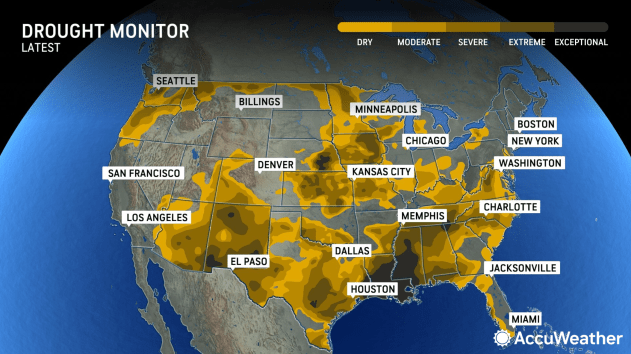
As Buckingham points out, after multiple days of no rain and very low humidity levels, which are also expected to accompany the warmth, leaves and other brush can dry out very quickly, providing the tinder for fires to erupt. On top of that, large stretches of the Midwest and East are considered either abnormally dry or in drought conditions, according to the latest U.S. Drought Monitor report.
Another important ingredient for fire risk is gusty winds, which will kick up at times, as multiple areas of low pressure and cold fronts venture from Canada into New England, creating a pressure gradient with the strong area of high pressure bringing in the milder weather.
The fire threat will be particularly robust on Monday in the northern Plains, Tuesday and Wednesday in the Upper Midwest and Thursday through Friday for the Great Lakes and Northeast. After that, an increasing chance of rain can put a lid on the fire risk.
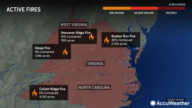
As of Sunday morning, multiple large wildfires were burning across the higher ground of the Southeast and mid-Atlantic, having already scorched thousands of acres, according to InciWeb.
 |
"The pattern could act as a hindrance to firefighters battling blazes in the East, as a result of low relative humidity levels and occasionally gusty winds," said Buckingham.
Want next-level safety, ad-free? Unlock advanced, hyperlocal severe weather alerts when you subscribe to Premium+ on the AccuWeather app. AccuWeather Alerts™ are prompted by our expert meteorologists who monitor and analyze dangerous weather risks 24/7 to keep you and your family safer.
