
Storms to repeat, drench parts of Midwest and Northeast


As a heat wave continues to sear much of the central and eastern United States, rounds of storms will roll across the Upper Midwest and Northeast this weekend bringing some relief from the heat. However, AccuWeather meteorologists warn that some of the storms will be severe, may hit suddenly and could trigger flash flooding.
 |
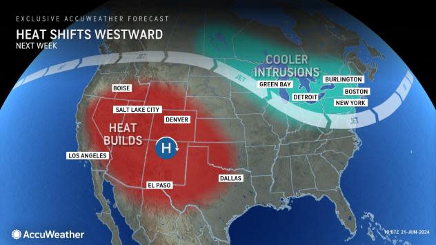
Thunderstorms erupting on the rim of a heat dome are quite common, as this is where the air rises instead of sinks, which prevents clouds. Rising air often leads to towering clouds, drenching showers and gusty thunderstorms in the summertime. Mountainous areas can also lead to thunderstorm formation. Disturbances or fronts moving around the edge of the heat dome can enhance thunderstorm activity. All of these modes for thunderstorms will be in operation into next week.
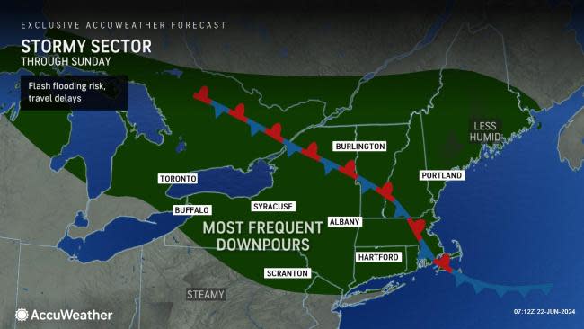
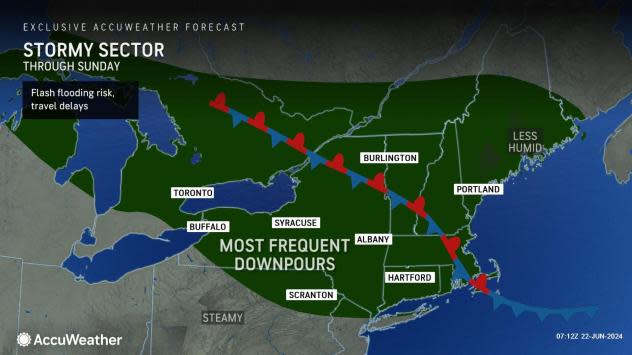
One area where thunderstorms will tend to erupt and repeat for multiple days will extend from central Ontario to New England through this weekend. However, storms will sometimes dip southward to the central Appalachians and part of the mid-Atlantic region.
 |
Much of the Northeast will not have frequent or excessive rainfall in the pattern. Most days, thunderstorm activity will tend to be rather sparse, but there will be some exceptions where downpours may repeat enough to disrupt outdoor plans and lead to flash flooding incidents.
"One spot where downpours may be heavy enough or linger long enough to cause flash flooding concerns will be near and just north of New York City on Saturday," AccuWeather Senior Meteorologist Brett Anderson said, "Areas from the lower Hudson Valley to Connecticut may be most at risk."
Depending on how and where thunderstorms erupt and cluster, other places may be hit with torrential rainfall on a highly localized scale.
 |
In terms of severe weather, thunderstorms will tend to erupt during the midday and early afternoon hours and reach peak intensity late in the day to the evening each day through this weekend.
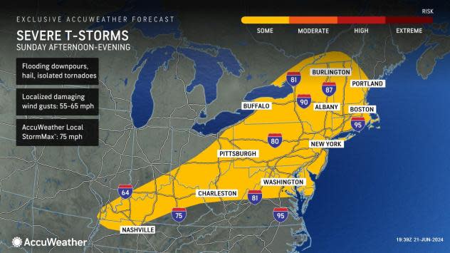
The likelihood of thunderstorms, including severe weather, will continue over the weekend in the Northeast. Severe weather will tend to focus on the Midwest on Saturday, but there will be an eastward extension of robust storms across New York, northern Pennsylvania, northern New Jersey, Connecticut, Massachusetts and Rhode Island.
 |
On Sunday, more of a regional threat of severe weather will tend to shift from the Great Lakes to the Appalachians and on toward parts of the mid-Atlantic and New England coasts later on.
The severe weather threat in the Northeast may include the potential for tornadoes.
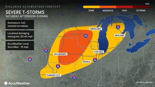
Another zone where showers and thunderstorms will tend to erupt and repeat will extend from portions of South Dakota and eastern Nebraska through central and southern Minnesota, northern Iowa, central and northern Wisconsin and northern Michigan on Saturday.
 |
"Part of this area has received a month's worth of rain in the past week, and the storms from Thursday to Saturday will have the potential to double those amounts or more," AccuWeather Meteorologist Brandon Buckingham said.
A general 1-4 inches of rain will fall in a span of 24-72 hours with some locations potentially receiving 4-8 inches of rain. Where the heaviest rain falls or intense downpours focus for a few hours or less, flash urban and small stream flooding is inevitable while surges along some of the rivers will follow.
The edge of the heat, along with the likelihood of localized flooding, will create a recipe for severe weather.
The threat of severe weather will continue in parts of the Central states on Saturday.
 |
The conditions produced by some of the strongest storms will be similar to that of Friday, including the potential for a few tornadoes, especially in parts of Iowa, Wisconsin, Illinois, Michigan and southeastern Minnesota.
As is the case with any thunderstorm, especially as activity tends to ramp up quickly during the afternoon hours, lightning often poses a significant risk to those spending time outdoors. Experts warn if thunder can be heard, there is a risk of being struck by lightning if outside.
Additional rounds of thunderstorms and severe weather are in store for the Midwest and Northeast well into next week. Severe weather may tend to focus, but not be limited to, erupting ahead of a strong cold front that will mark the end of the heat wave and a change in the weather pattern during the middle and latter part of next week.
 |
Want next-level safety, ad-free? Unlock advanced, hyperlocal severe weather alerts when you subscribe to Premium+ on the AccuWeather app. AccuWeather Alerts™ are prompted by our expert meteorologists who monitor and analyze dangerous weather risks 24/7 to keep you and your family safer.
