
Northeast faces 1st heat wave of 2024 after severe storms


The first extended stretch of summertime heat and humidity is on the way to the Northeast with temperatures expected to challenge records during the second half of June. Before that happens, AccuWeather meteorologists are expecting a round of intense thunderstorms in the region that could impact travel and outdoor plans just as the weekend gets underway.
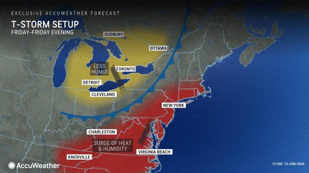
The risk of strong storms will come on Friday in the East, following an active Thursday in the nation's midsection. As a cold front moves east clashing with very warm and humid air, thunderstorms will form and can turn severe, producing a variety of hazards to end the week.
 |
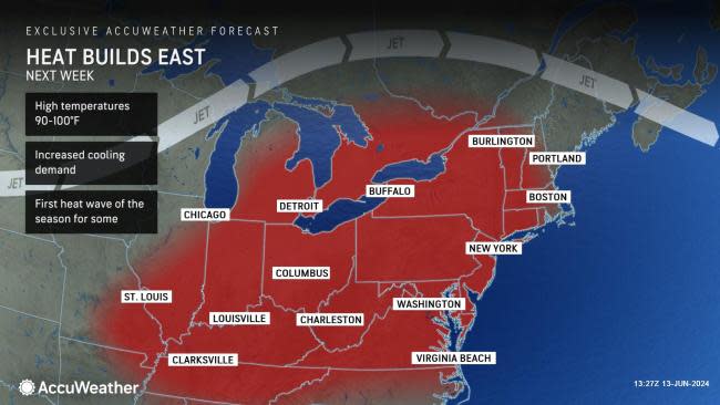
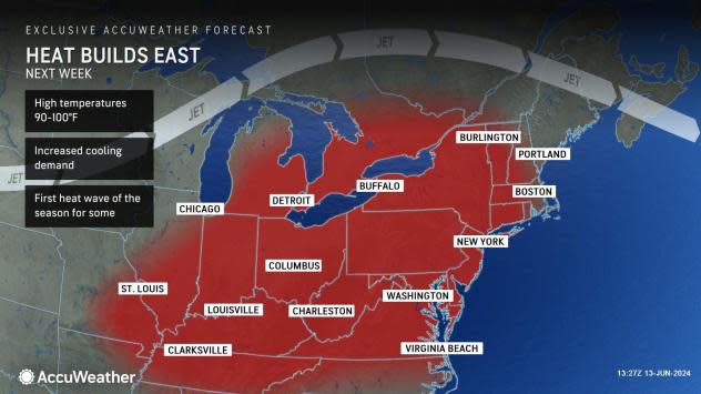
After a brief cooldown behind the front, a heat dome will build into the region, promoting the hottest weather of the season thus far, aligning nearly perfectly with the official start of astronomical summer on June 20.
Following a cool and tranquil start to the week in the Northeast, changes are ahead for the rest of the week that will culminate in dangerous thunderstorms.
"Over the next couple of days, a storm will move from the northern Plains to the Midwest before it arrives in the Northeast on Friday," said AccuWeather Senior Meteorologist Joseph Bauer. "Ahead of this storm, several days of southerly wind in the Northeast will bring in warmer, more humid air."
 |
The warmth will begin to be noticeable in the region on Thursday, when temperatures climb a few degrees above the historical average, into the 80s for most. On Friday, higher humidity levels will be added to the mix, providing a fertile breeding ground for storms.
"A cold front will tap into the warmer, more humid air and, when coupled with the storm, will make for a favorable environment for thunderstorms to develop in," said Bauer.
AccuWeather's severe weather experts have highlighted a risk area of severe weather on Friday afternoon and evening that includes a large area from the Appalachians and mid-Atlantic to New England. The main threats from storms will be large hail and damaging wind gusts.
 |
"For the Appalachians, we could see thunderstorms develop early in the day whereas the threat for the Interstate 95 corridor looks to be in the afternoon and evening hours," noted Bauer. "Rain and thunderstorms look to largely shift off the coast by the later overnight hours Friday."
Millions of people will be under this severe weather threat, covering multiple large metropolitan areas from Washington, D.C., to Portland, Maine. Travelers at airports and along portions of Interstates 76, 80, 81, 87, 90, 91 and 95 will also face delays as their weekend activities commence.
"In cities such as Philadelphia, New York and Boston, any late afternoon and evening plans could be impacted by severe weather which could include hail and damaging wind gusts," said Bauer. "Keep an eye on AccuWeather MinuteCast™ for specifics on when storms can arrive."
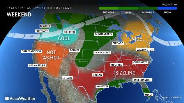
Following the strong storms on Friday, the weekend will start with more comfortable weather, but AccuWeather meteorologists are warning residents and visitors not to get used to this change.
 |
"In the wake of this severe threat, the cold front will do its job in bringing a few days of cooler air, but it's a short reprieve," said Bauer. "Next week, high pressure currently over the West can move over the mid-Atlantic, setting the stage for a significant warmup."
That significant warmup will push temperatures well into the 90s for most away from the coast and even challenge long-standing record-high temperatures. Combined with an uptick in humidity, AccuWeather RealFeel™ Temperatures will exceed 100 degrees multiple afternoons.
While some cities have already ventured into the 90s so far this year, including Baltimore, Cleveland, and Harrisburg, Pennsylvania, many more will notch their first 90-degree readings next week.
 |
According to Bauer's research, the average first 90-degree day in Detroit and Indianapolis is June 15, while in Pittsburgh the average first day is typically later, around June 21. New York City has also officially not been in the 90s yet this year, and that usually occurs around June 3. All are forecast to reach that milestone multiple times during the second half of June.
The heat will peak around the official start of summer, which occurs next Thursday, June 20, at 4:50 p.m. EDT. In the days leading up to the solstice, the mercury will approach or touch 100 degrees briefly in a few locales, including in the typical urban hotspots such as Newark, New Jersey, and Richmond, Virginia.
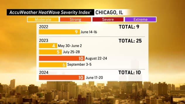
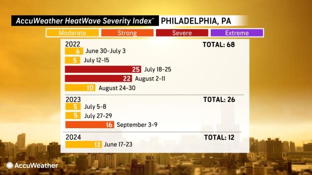
One way to measure the intensity of a heat wave is through AccuWeather's HeatWave Counter and Severity Index™. In Philadelphia, for example, the upcoming heat wave is expected to reach into the "moderate" range of the index.
 |
To combat the heat and stay safe, AccuWeather experts are advising residents to limit their time in non-air-conditioned environments during the upcoming heat wave. Since that is not an option for those working outdoors, staying hydrated and taking breaks in the shade is advised to reduce the risk of heat-related illnesses.
Want next-level safety, ad-free? Unlock advanced, hyperlocal severe weather alerts when you subscribe to Premium+ on the AccuWeather app. AccuWeather Alerts™ are prompted by our expert meteorologists who monitor and analyze dangerous weather risks 24/7 to keep you and your family safer.
