
Storm Ciaran spreading strong winds, heavy rain in western Europe


 |
AccuWeather meteorologists are tracking a significant windstorm, the strongest storm so far this season, that will continue to impact western Europe through the end of the week.
A low pressure area that started the week over the northeastern United States has quickly made its way across the northern Atlantic Ocean, interacting with a dip in the jet stream near western Europe. As predicted by AccuWeather meteorologists, this combination caused the system to rapidly intensify with winds spiking by more than 35 mph in 24 hours or less.
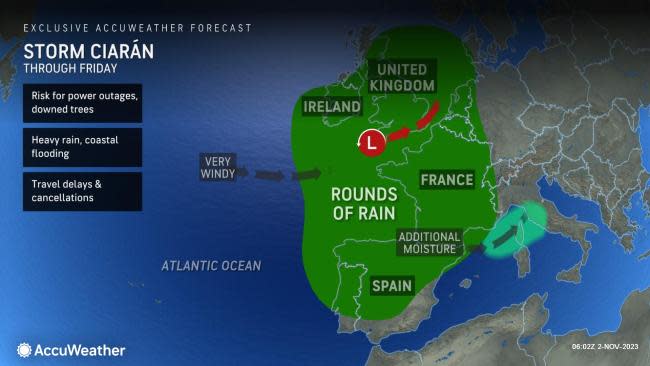
The storm has been designated as Storm Ciarán by the U.K. Met Office. Damaging winds, heavy rain, high seas and coastal flooding are expected to continue through Friday, and forecasters say that it will have the potential to produce the strongest low pressure ever recorded in the United Kingdom.
The intensity of the storm could cause the pressure in the U.K. to drop to near-record levels. Currently, the November low-pressure record is 28.02 inches of mercury (948.8 millibars), set in 1954, according to AccuWeather Senior Meteorologist Tyler Roys.
Rounds of rain will continue to spread across much of western Europe through Friday as Storm Ciarán tracks over the region. The heaviest rain is expected across portions of northwestern Spain, the southwestern and northern coast of France and parts of northern Italy. Heavy rain can lead to flash flooding and slow travel on roadways.
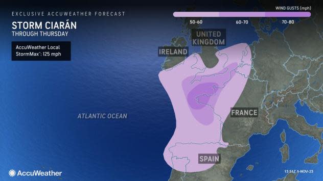
Winds may gust up to 60 mph across a large area of western Europe from northern Spain into southern England and the Netherlands, including cities like Brussels, Paris and London. A small zone of 70-80 mph can occur across far northwestern France, with an AccuWeather Local StormMax™ of 125 mph.
Gusty winds across the region already have caused power outages, downed trees and damage to structures and as of early Thursday morning, local time, one person has been killed in the storm, with over 1 million power outages in parts of France, according to CNN. Areas across western Europe where trees still have the majority of their leaves can experience a heightened risk of widespread power outages and downed trees.
 |
Ciarán will also stir up the seas as it moves across the area. Waves between 20-40 feet may occur across northern portions of the Bay of Biscay into the English Channel. High seas across the region can cause coastal flooding in exposed areas.
"Ferry operations across the English Channel will also be impacted by the high seas, likely resulting in delays and cancellations," adds Roys.
Rain from Ciarán could linger across the region Friday before a separate storm is expected to bring another round of heavy rain and gusty winds to western Europe throughout the weekend.
Want next-level safety, ad-free? Unlock advanced, hyperlocal severe weather alerts when you subscribe to Premium+ on the AccuWeather app. AccuWeather Alerts™ are prompted by our expert meteorologists who monitor and analyze dangerous weather risks 24/7 to keep you and your family safer.
