
Storm delivers snow, slippery travel from DC to Philadelphia, NYC and Boston


The same storm responsible for accumulating snow in Dallas and Nashville will continue its run through Tuesday across the Northeast. Enough snow has already fallen to snap the snow drought in Washington, D.C., Baltimore, Philadelphia and New York City, AccuWeather meteorologists say.
"Unlike the flurries and snow squalls that drifted across the area on Sunday and mainly melted on roads, lower temperatures in place for the storm in the Northeast will lead to slippery and snow-covered roads and sidewalks in many cases," AccuWeather Senior Meteorologist Matt Benz said.
 |
While the storm will be far from a blockbuster in snow accumulations in the Northeast, it will produce a broad swath where 1-6 inches will fall with locally higher amounts. This time, the accumulating snow will extend through much of the Interstate 95 zone from Virginia to Maine, including in areas that have avoided much in the way of accumulating snow since two winters ago.
As is often the case, there will be just enough mild air to allow rain or a wintry mix near the coast. The wintry mix includes some sleet and dangerous freezing rain.
 |
Where the air will be a bit colder, there will be areas where 3-6 inches of snow will fall, mainly north of New York City and northwest of Boston.
Heavier snow is forecast to fall on the Appalachians from western Maryland to portions of West Virginia, eastern Kentucky and Tennessee. A general 6-12 inches of snow will pile up with an AccuWeather Local StormMax™ of 15 inches.
Another pocket where 6-12 inches of snow may be possible is in parts of central and northern New England, where the storm can get strong enough, slow down a bit and grab more moisture from the Atlantic Ocean.
Regardless of the amount of snow that falls in the Northeast, the snow, ice and frigid air will continue to lead to a large number of airline delays and flight cancellations throughout the nation, as ice from the storm extended as far south as Houston during the midday hours on Monday.
 |
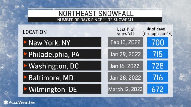
While there have been some close calls, it has been two years since the area from Washington, D.C., to New York City has picked up an inch of snow or greater in a single calendar day before the storm early this week. Nashville and Dallas, edged out the I-95 mid-Atlantic cities for its first inch of snow this year. Dallas picked up 1.5 inches of snow while Nashville recorded 7.6 inches spanning Sunday and Monday.
Washington, D.C., picked up 3.4 inches of snow on Monday. Meanwhile, Baltimore picked up 4.1 inches, with Philadelphia recording 1.5 inches of snow. Additional snow fell early Tuesday in all three cities. As of daybreak Tuesday, New York City officially recorded an inch of snow at Central Park.
The last time there was an inch of snow in New York's Central Park was on Feb. 13, 2022. However, at Regan National Airport in Washington, D.C., an inch of snow was further back that same winter, on Jan. 16, 2022.
 |
This graphic shows the string of days without an inch of snow prior to the storm that affected the region from Monday to Tuesday. |
A separate stripe where about an inch of snow will fall with travel delays will extend across portions of Indiana, central Ohio and parts of Michigan into Tuesday morning.
In the wake of the storm, Arctic air will linger, allowing untreated wet and slushy areas to freeze Tuesday evening and night. Motorists and pedestrians should use extra caution as many accidents occur after the storm as runoff and puddles freeze rather than as the snow falls.
 |
After the cold air bottoms out at midweek, a slight uptick in temperatures is in store for the Northeast on Thursday ahead of the next storm, Benz said.
How organized that storm gets will determine whether or not there are just some pockets of light snow scattered about the region or if a more general zone with a moderate accumulation of a few inches occurs, Benz explained.
 |
Like the storm into Tuesday, odds are against a widespread heavy snowfall, but it will have to be watched for last-minute strengthening, which could result in heavier precipitation. The slight rise in temperature ahead of the late-week storm could result in some mixed precipitation along and south and east of I-95.
"Behind that late-week storm, Arctic air may more forcefully push into the Eastern states this weekend, compared to this past weekend," Benz said. "The main thrust of the cold air will be directed more to the Southeast, rather than southward over the Plains like the current Arctic outbreak."
 |
Many locations east of the Mississippi River may end up having their lowest temperatures of the winter late as an Arctic high pressure area settles in with frigid breezes by day and clear and bitterly cold conditions at night.
For example, in New York City, temperatures have been no lower than 23 F, as of early Tuesday morning, Jan. 16. However, temperatures may struggle to reach that high during the day on Saturday and may plunge into the teens at night.
As the waves of cold continue to blast from the Arctic, yards of lake-effect snow will pile up in parts of the Upper Midwest and the interior Northeast.
Want next-level safety, ad-free? Unlock advanced, hyperlocal severe weather alerts when you subscribe to Premium+ on the AccuWeather app. AccuWeather Alerts™ are prompted by our expert meteorologists who monitor and analyze dangerous weather risks 24/7 to keep you and your family safer.
