
Snow to accompany Arctic air surge from Rockies to Plains


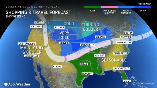
Crashing temperatures and accumulating snow are no strangers to the Rockies and Plains, but the setup will allow a period of snow and push of Arctic air to extend into the central United States as the extended Thanksgiving weekend progresses, AccuWeather meteorologists warn.
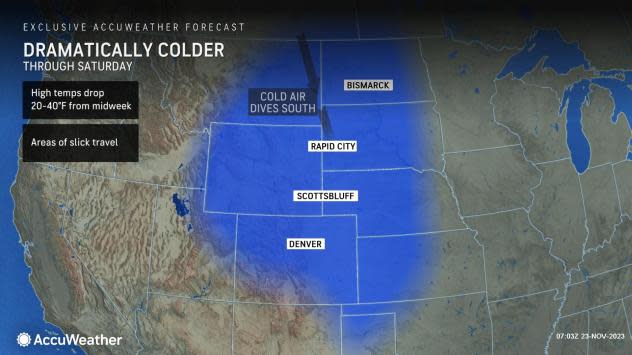
Temperatures surged over the central Rockies and Plains on Wednesday ahead of a blast of Arctic air. However, Arctic air was sweeping southward over the region as the region began to celebrate the Thanksgiving holiday.
Following high temperatures well into the 60s to near 70 F from Cheyenne, Wyoming, to Denver and Colorado Springs, Colorado, and Amarillo, Texas, temperatures will plunge 20-50 degrees in some places from their peak by Friday morning.
 |
At Denver, temperatures dove from their afternoon high of 68 on Wednesday to the upper 20s on Thanksgiving morning before sliding into the teens on Thursday night. In the Texas Panhandle, temperatures will head downward from their high mark near 70 on Thanksgiving Day afternoon to the upper 20s by Friday morning.
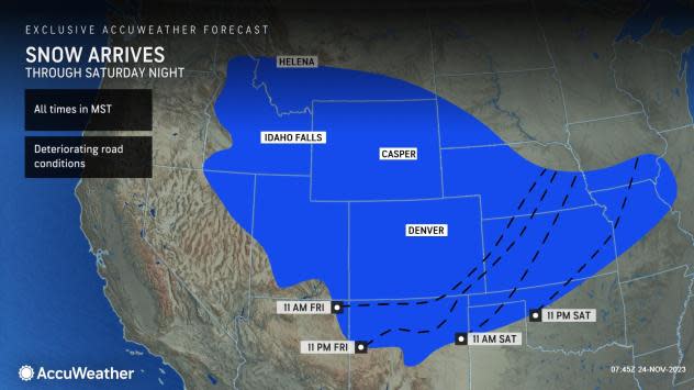
The impending temperature plunge will be accompanied by some snow, and not just a few flurries, but a legitimate winter storm that could result in plowable snow in parts of the Plains and Rockies.
 |
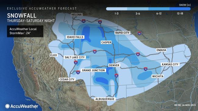
The track of the storm and specific setup will allow the heaviest snow to avoid the immediate Denver downtown area, but substantial snow will fall well to the northeast of the city in southwestern Nebraska and southeastern Wyoming, where 3-6 inches is in store.
The Denver metro area can expect 1-4 inches of snow to fall, with the greatest amounts in the foothills to the immediate west of the city.
 |
Much heavier snow will fall along the Front Range and well into the mountains over central Colorado, the ranges in Wyoming and the mountains in northern New Mexico through Friday. In these areas, accumulations will range from 6-18 inches with an AccuWeather Local StormMax™ of 24 inches. Slippery and snow-covered roads are likely along vast segments of Interstates 25, 70, 76 and 80 in the region.
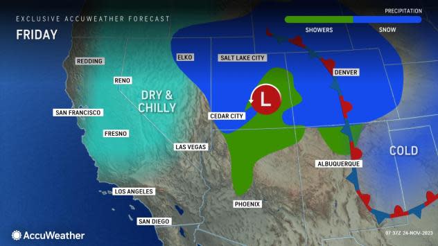
Some snow will even spill farther to the west over Idaho and much of Utah into Friday. Several inches of snow will fall on the Wasatch Range, but even the lower elevations of Salt Lake City to the west are likely to pick up a coating to an inch of snow, mainly on non-paved surfaces, into Friday morning.
 |
Snow will also spread into the southern High Plains, where Amarillo, Texas, has the potential to pick up a coating to an inch of snow from Friday night to early Saturday. The last time that accumulating snow fell in Amarillo was on March 16, 2023.
The legacy of snow from the storm will not end over the Rockies and High Plains. Soon after dropping southward, this storm will swing northeastward from Saturday night to Sunday. As the storm pivots eastward, it will begin to merge with another system rolling in from Canada while also tapping into moisture from the Gulf of Mexico.
The strengthening system will then deliver a stripe of snow to extend northeastward well out across the central Plains and into the Great Lakes region from later Saturday to Sunday.
The first push of cold air will arrive over the Great Lakes region on Friday. Temperatures will be slashed by 10-20 degrees on average from midweek highs.
 |
A second push of cold air will allow snow to fall, road surfaces to cool and some of the snow to accumulate. Motorists traveling over Interstates 29, 35, 70, 80 and others over the Central states from Saturday night to Sunday should be prepared for patches of slippery travel from snow of varying intensity and road conditions ranging from wet to slushy and even icy in spots.
Where and when snow falls from the Intermountain West to the Great Lakes region will force officials to de-ice aircraft, which may add to airline delays. The greatest risk of flight cancellations will be over the airports in the Rockies, perhaps including Denver International Airport.
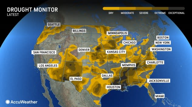
A chilly rain will spread eastward and fall just south of the zone of snow. The wet weather will spread over the southern Plains to the middle part of the Mississippi Valley and the Ohio Valley this weekend and may provide an additional easing of drought conditions in the region following the storm from earlier this week.
 |
Want next-level safety, ad-free? Unlock advanced, hyperlocal severe weather alerts when you subscribe to Premium+ on the AccuWeather app. AccuWeather Alerts™ are prompted by our expert meteorologists who monitor and analyze dangerous weather risks 24/7 to keep you and your family safer.
