
Severe weather to roar from Texas to Missouri, Ohio, Pennsylvania and Maryland


All modes of severe weather, including tornadoes, are likely from the southern Plains to the Ohio Valley and storms packing big hail may extend into the mid-Atlantic region through midweek, AccuWeather meteorologists warn.
There will be a significant risk to lives and property through April's first couple of days (and nights).
Severe weather into Sunday night was only a mere introduction as to the magnitude and scope of the power and areal extent of thunderstorms upcoming from Monday to Tuesday night.
On Saturday, thunderstorms packing strong wind gusts and hail to the size of half-dollar coins erupted from Indiana to West Virginia.
Into Sunday night, this same frontal zone lit up with severe thunderstorms that brought hail, flash flooding and locally strong wind gusts from southern Iowa and northern Missouri to southwestern Pennsylvania and northern West Virginia. One thunderstorm in particular produced tennis ball-sized hail in parts of central Illinois, according to reports from the Storm Prediction Center.
 |
However, the big period in terms of the scope and intensity of severe weather will be from Monday evening through Tuesday evening. During this stretch, severe thunderstorms may extend along a 1,500-mile-long swath and home to at least 100 million people.
Well into Monday night, the risk of severe thunderstorms capable of producing high winds, large hail, flash flooding and tornadoes will extend northeastward from central Texas to central Missouri eastward to southern Ohio and much of Kentucky. The risk of severe weather, perhaps minus the tornado threat, will extend through much of West Virginia and southern and western Virginia.
"Within the northern part of the zone, encompassing part of the Midwest, more than one severe thunderstorm may directly impact some communities," AccuWeather Meteorologist Matt Benz said.
 |
Should the severe weather evolve to its full potential, some of the tornadoes that develop could be strong and on the ground for more than a couple of minutes over portions of the southern Plains to Missouri. AccuWeather meteorologists have added a high-risk zone to highlight this prime threat area.
"The storms that erupt in the southern Plains area, in portions of Oklahoma, Texas and southern Arkansas, may hold off until late in the day Monday, while storms farther to the north are possible at just about any time through Monday night," Benz said. It is the storms over parts of the central and southern Plains that have the potential to bring hail to the size of baseballs or larger.
On Tuesday, the severe weather threat will shift eastward over the Mississippi Valley portion but continue over a large part of the Ohio Valley and may extend all the way to the mid-Atlantic coast.
 |
At this time, the risk of severe weather on Tuesday will extend from southern Mississippi northward to Indiana, Ohio, southwestern Pennsylvania and Maryland. However, the risk of severe storms will exist all the way to the central Gulf coast, western and northern Georgia, parts of the Carolinas and much of Virginia.
Similar to the severe weather from Monday night, all modes of severe weather will be possible on Tuesday, with some storms packing hail and high winds, as well as flash flooding and tornadoes. The area from Ohio to eastern Kentucky and middle Tennessee may be the hot spot for tornadoes.
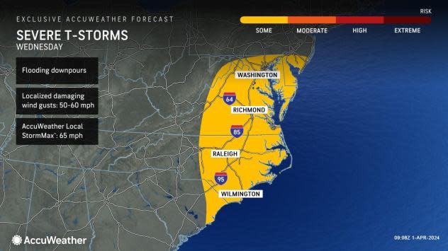
By Wednesday, the threat for severe thunderstorms will focus mainly along the mid-Atlantic coast as the cold front pushes through the region. In addition to locally damaging winds, heavy rain can lead to ponding on streets and highways, as well as travel delays.
 |
The risk of severe weather will extend after dark early this week and could affect some communities late at night. This is why having an audible means of receiving severe weather bulletins when sleeping is important and could prove life-saving. Those spending time outdoors should keep an eye out for changing weather conditions and move indoors at the first rumble of thunder.
As severe thunderstorms erupt and approach the airport hubs, the likelihood of flight delays will increase, with the potential for some flights to be canceled.
Have the app? Unlock AccuWeather Alerts™ with Premium+
As rainfall repeats into Tuesday night, from parts of the middle Mississippi Valley to the central Appalachians and mid-Atlantic, flash flooding is likely and the potential for small stream and secondary river flooding will increase. Those living along unprotected areas of streams prone to flooding should be prepared for inundation. Some secondary roads may become blocked by stream flooding.
Want next-level safety, ad-free? Unlock advanced, hyperlocal severe weather alerts when you subscribe to Premium+ on the AccuWeather app. AccuWeather Alerts™ are prompted by our expert meteorologists who monitor and analyze dangerous weather risks 24/7 to keep you and your family safer.
