
Severe weather outbreak possible this weekend across the South, East


With a massive storm looming on the horizon this weekend across the central and eastern United States, AccuWeather meteorologists are becoming increasingly confident that dangerous thunderstorms will threaten millions of residents along its path.
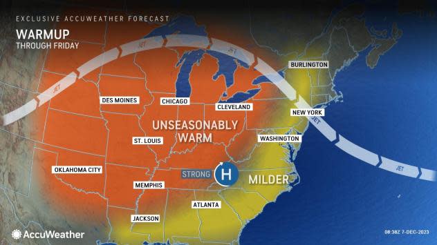
Between Thursday and Friday, persistent winds flowing out of the Gulf of Mexico will boost temperatures and humidity levels across the central and eastern United States, providing some of the ingredients necessary for rain and thunderstorms.
 |
As cold air rushes in on the back side of the storm and meets up with the mild and humid air, the clashing air masses will spark severe thunderstorms across the south-central U.S. Friday before extending across the South on Saturday.
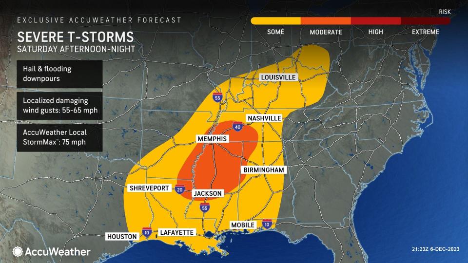
During Friday night, severe storms can ignite from eastern Oklahoma and west-central Arkansas to Springfield, Missouri. Risks including hail and damaging wind gusts of 55-65 mph can accompany any severe thunderstorms. From Shreveport, Louisiana, to Louisville, Kentucky, and areas in between, damaging winds, hail and even a tornado or two could all unfold on Saturday.
 |
AccuWeather meteorologists continue to monitor the latest information to see if the risk of severe weather can extend even farther north on Saturday.
Strong, damaging winds may also pose a risk to areas where no thunderstorms develop.
"Increasingly strong winds above the surface between Saturday and Saturday night across the middle Mississippi and Ohio valleys could pose a damaging wind threat despite limited instability across the region," AccuWeather Meteorologist Grady Gilman stated.
 |
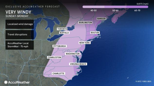
Outside of the expected severe thunderstorm zone this weekend, the powerful storm system could spawn widespread winds of 40-60 mph, with an AccuWeather Local StormMax™ of 75 mph.
Winds of this magnitude can wreak havoc on holiday decorations, cause numerous airport delays and cancellations and threaten to tip over high-profile vehicles.
 |
On Sunday, the risk of thunderstorms and damaging wind gusts will shift toward the Eastern Seaboard as a powerful cold front surges into the region.
Thunderstorms can quickly blast through the East as powerful winds steer the wet weather toward the Atlantic coast. Within any heavy shower or thunderstorm that treks through the East on Sunday, locally damaging wind gusts will be possible.
 |
In addition to the wind threat on Sunday, heavy rain will also sweep through the East, elevating concerns for localized flooding, particularly in urbanized areas where it can be difficult for water to run off or be absorbed into the ground. Places like New York City and Philadelphia southward down to Charlotte, North Carolina, and Charleston, South Carolina, all can face this flood threat.
Heading into next week, the severe thunderstorm and heavy rain threat will quickly decrease as the storm shifts off the Atlantic coast.
Want next-level safety, ad-free? Unlock advanced, hyperlocal severe weather alerts when you subscribe to Premium+ on the AccuWeather app. AccuWeather Alerts™ are prompted by our expert meteorologists who monitor and analyze dangerous weather risks 24/7 to keep you and your family safer.
