
11 million people in South Florida face flash flood dangers


A flood watch remains in effect for southeastern Florida as downpours have already unleashed heavy rain across the zone from Miami to Fort Lauderdale, triggering rapid urban flooding.
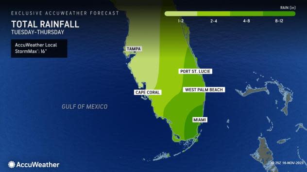
AccuWeather meteorologists warned on Tuesday that 11 million people in southeastern Florida would be at risk for flash flood dangers into Thursday, with excessive rainfall likely through Wednesday night.
The atmosphere wasted no time commencing the downpours. The corridor from Miami to Fort Lauderdale picked up 2-6 inches of rain Tuesday evening. On Wednesday, heavy rain continued to fall, with the Miami International Airport picking up an additional 7.53 inches, and the Fort Lauderdale airport receiving another 2.84 inches. More significant rainfall will persist into Thursday.
The National Weather Service issued a flood watch for the region, adding that there is a "highly impactful urban flash flooding" threat. Ponding of water on highways is likely, especially in areas that drain poorly, AccuWeather meteorologists say.
 |
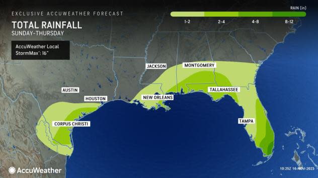
The culprit behind the extreme rainfall is a storm in the Gulf of Mexico that has already unleashed several inches of rain along the western and central Gulf coast.
"As the storm moves from west to east across the Florida Peninsula, it will tap tropical moisture from the Caribbean," AccuWeather Storm Warning Meteorologist Joe Bauer said.
Moisture is sufficient from the Gulf to trigger intense downpours, but once tropical humidity is injected, rainfall potential will be boosted, Bauer said.
Bauer pointed out that southeastern Florida, in particular the Miami and Fort Lauderdale areas, is highly likely to be a trouble spot where moisture converges, leading to significant flash flooding. A general 8-12 inches of rain will fall in this area, with locally much higher amounts, through Thursday. There is an AccuWeather Local StormMax™ of 16 inches in southeastern Florida.
 |
Intense rain rates are likely, and several inches of rain can fall within an hour or a couple of hours, overwhelming storm drain infrastructure.
This region of the Sunshine State is no stranger to excessive rainfall events. In April, a storm unloaded 12-24 inches of rain in about 24 hours, which resulted in the inundation of some neighborhoods in the Fort Lauderdale area, including the airport.
The enhanced rainfall may be fueled by a secondary disturbance emerging from near Cuba. That disturbance is likely to take over as the main storm and then swing northward to affect New England as a nor'easter on Saturday.
 |
Some of the rain may dissipate during energy transfer from the older Gulf storm to the new storm that develops near the Florida Straits. However, much of Florida will likely receive at least some rain from the system before its departure later Thursday and Thursday night.
Forecasters recommend rain gear for those heading to area theme parks in Orlando and Tampa well ahead of Thanksgiving week.
But the rainfall will have a silver lining. The same storm triggering the downpours may act as a bit of a buffer or protection against a tropical system brewing in the western Caribbean. As the storm near Florida lifts northward, west-to-northwest winds in its wake will help to keep any intensifying tropical system from the Caribbean well to the east of the United States.
 |
Another benefit of the Gulf/Florida Straits system will be drought-easing rain for some locations. Close to 80% of the Sunshine State was experiencing abnormally dry conditions or worse, according to the latest report from the United States Drought Monitor.
Rain was already falling on the extreme drought area in the western part of the Florida Panhandle Tuesday. Some rain is likely to fall on drought-stricken areas, similar in severity, along the west-central part of the Florida Peninsula.
The combination of the developing storm and an area of high pressure over the western Atlantic will create stiff east-to-northeast winds along Florida's east coast and northward through the Carolinas for much of this week. Swimmers will be at risk for pounding waves and strong rip currents.
 |
The stiff onshore winds and above normal tides will ease in Florida as the storm moves northward Friday.
A little moisture will likely remain behind into Saturday over Florida, so spotty showers cannot be ruled out. The shower activity will end once a cold front pushes through the state during the weekend.
Orlando, Fort Lauderdale and Miami are the top three Thanksgiving travel destinations, according to the American Automobile Association (AAA). Huge numbers of travelers -- 55 million-plus -- are expected to hit the roads, skies and rails this Thanksgiving across the U.S., according to AAA's projection for 2023.
For those heading to the Sunshine State next week, conditions look to be dry most of the time.
However, there is the potential for a storm to bring showers and thunderstorms, resulting in travel delays in the days immediately after Thanksgiving. The wettest days will depend on the speed and strength of the storm. That same weather maker will likely produce a swath of rain from the lower Mississippi Valley to the Northeast, which could lead to delays at significant travel hubs during the early to middle part of next week.
 |
Around the central Florida theme parks, highs most days next week will be in the middle to upper 70s F, with nighttime lows in the mid-50s to near 60 next week, though there can be some highs in the lower 80s early in the week. Meanwhile, highs at the southeastern Florida beaches will be mainly in the 80s, with nighttime lows within a few degrees of 70.
Want next-level safety, ad-free? Unlock advanced, hyperlocal severe weather alerts when you subscribe to Premium+ on the AccuWeather app. AccuWeather Alerts™ are prompted by our expert meteorologists who monitor and analyze dangerous weather risks 24/7 to keep you and your family safer.
