
Rain, severe weather potential eyes Texas to Tennessee


AccuWeather meteorologists say that although the final days of November may be dry for most of the South, stormy weather is expected to surge into the area later this week, bringing with it the risk for flooding and severe thunderstorms.
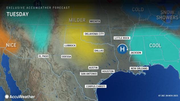
"Dry and tranquil weather is expected across the southern Plains and the mid-South through midweek due to an area of high pressure moving pretty slowly from Oklahoma to northern Mississippi," said AccuWeather Senior Meteorologist Dan Pydynowski.
 |
The lack of precipitation comes in the wake of an expansive storm that brought a fresh blanket of snow from Kansas and Oklahoma into the Midwest, with a brief spell of rain spreading from Texas through the southern U.S. over the Thanksgiving holiday weekend.
The coldest air, relative to the historical average, will settle into the eastern third of the nation through Wednesday. For many in the Southeast, the temperatures will fall to the lowest levels so far this season before gradually rebounding later in the week.
Have the app? Unlock AccuWeather Alerts™ with Premium+
The dry weather that began the week, however, is not expected to last throughout the week.
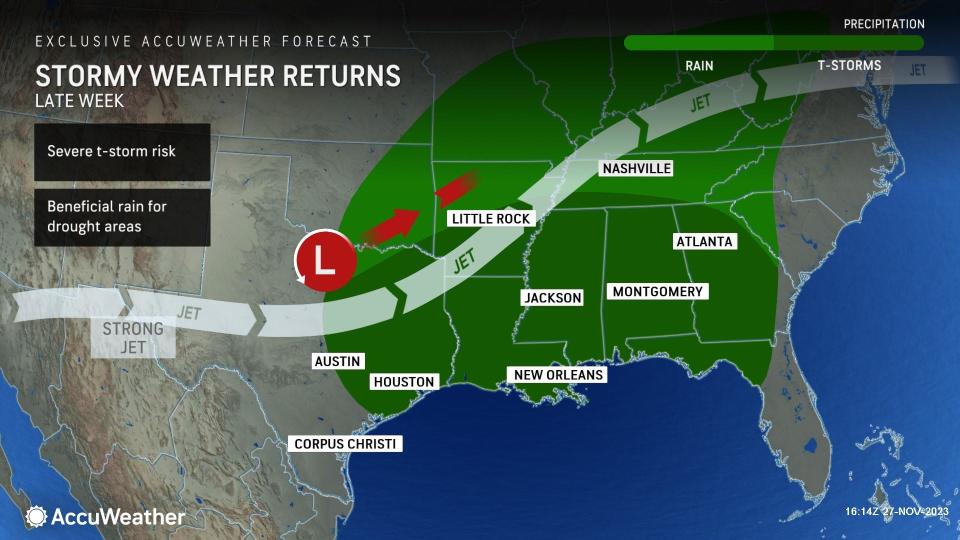
A storm is expected to move into Southern California at midweek before moving into the southern Plains Thursday or Friday. As it moves into this area, winds will turn out of the south, providing a surge of warmth and moisture.
"Cool air being pulled down from the Rockies, combined with the warm air from the Gulf of Mexico, is likely to provide the right atmospheric conditions for some robust thunderstorms," explained Pydynowski.
 |
The exact track of the storm as it moves from the southern Plains into the Mississippi River Valley will be vital in determining the locations most susceptible to severe risks like damaging winds, hail, or an isolated tornado or two. A more southerly track will limit the violent weather closer to the Gulf Coast, while a more northerly track would allow for more widespread thunderstorms.
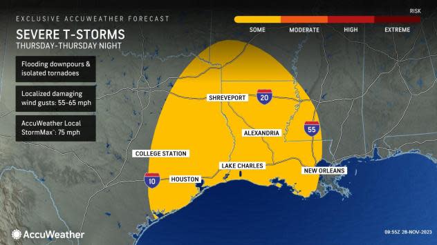
At this time, the area from the upper Texas coast to southern and central Louisiana appears to be at risk for severe thunderstorms from Friday afternoon to Friday night. Storms can bring flooding downpours and even an isolated tornado.
 |
AccuWeather forecasters say that rainfall amounts could range anywhere between half an inch to an inch from central Oklahoma and Texas to Tennessee and Alabama, with locally higher amounts as high as 2 inches just west of the Mississippi River. Cities such as Dallas and Houston, Texas; Little Rock, Arkansas; Jackson, Mississippi; and New Orleans and Shreveport, Louisiana, are likely looking at another dose of rain as the calendar turns to December.
"If heavy thunderstorms repeatedly hit the same area for a couple of days, this could bring the threat of flash flooding. However, much of the area at risk is still in quite a drought and could use the rain," Pydynowski said.
 |
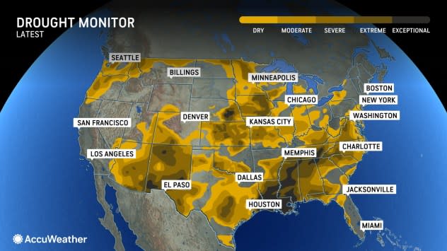
According to the U.S. Drought Monitor, there has been some improvement to the drought in parts of Texas during the month of November. However, 99% of Louisiana is still in some sort of drought, and 87% is in an extreme or exceptional drought, the two most significant drought levels on the scale. Meanwhile, 90% of Mississippi is also in an extreme or exceptional drought.
The recent dry conditions could put the area more at risk for flash flooding, with the ground unable to absorb any rainwater that accumulates quickly. Downpours could cause ponding, especially in low-lying and poor drainage areas, but could also cause reduced visibility and slowed travel. Motorists traveling on interstates such as 10, 20, 49 and 55 should continue to monitor the weather for updates.
AccuWeather's Long-Range Forecasting team says that there might even be another storm that brings rain to the Gulf and the southern U.S. for the first weekend of December, adding to flash flooding concerns and perhaps interrupting outdoor holiday festivities.
AccuWeather's expert team of meteorologists will continue to provide more details about the locations at risk for severe thunderstorms and heavy rain as the week progresses.
Want next-level safety, ad-free? Unlock advanced, hyperlocal severe weather alerts when you subscribe to Premium+ on the AccuWeather app. AccuWeather Alerts™ are prompted by our expert meteorologists who monitor and analyze dangerous weather risks 24/7 to keep you and your family safer.
