
Potent storm bringing intense flooding to Southeast coast

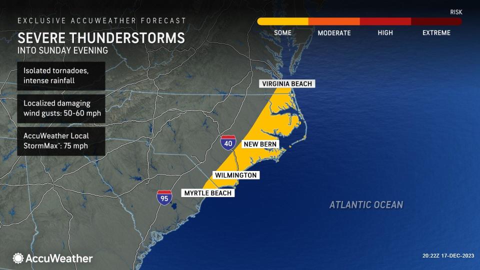

Severe thunderstorms, some spawning tornadoes and unleashing intense rainfall, are expected to blast parts of the Southeast through the remainder of this weekend, upending outdoor plans and endangering lives and property, AccuWeather meteorologists warn.
A strengthening area of low pressure in the Gulf of Mexico became more organized before moving ashore in central Florida Saturday night. As the storm continues to track northward, drenching rain will occur first in many areas, then severe storms may ignite along the coast into parts of southeastern Virginia through Sunday night.
Places like Myrtle Beach, South Carolina and much of eastern North Carolina all could experience damaging storms, with the risk eventually extending as far north as the Virginia Beach area.
By late Sunday morning, the streets of downtown Charleston, South Carolina, were flooded from a dangerous combo of high tides and torrential rainfall. As of midday Sunday, the Charleston Harbor tide gauge showed levels of 9.86 feet and rising.
"The current tide report places them at 4th place for all-time highest tide levels, and highest tide level recorded for a non-tropical system," explained AccuWeather Meteorologist Matt Benz.
Flood watches were put into effect across eastern South Carolina on Sunday after 24-hour rainfall totals surpassed 8 inches in some coastal locations north of Charleston. Numerous reports of impassable streets and flooded roadways resulted in a flash flood emergency in the city.
Severe storms can cause delays for early holiday travelers on the road and in the air across the Southeast through Sunday night. Forecasters urge motorists to allow for extra travel time as flooding on roadways and reduced visibility can occur. People with flights in major airports across the region should be prepared for potential delays or cancellations due to severe weather.
Forecasters are emphasizing that the threat of tornadoes may continue after dark from the Carolinas into Virginia. Nocturnal tornadoes are considered more dangerous because they are difficult to see and people are often sleeping or not paying attention to the weather conditions outside when they spawn.
Given the risk of severe storms into the evening hours, residents from the coast of the Carolinas into southeastern Virginia are urged to make sure that they have a way to receive potentially life-saving emergency watches and warnings, such as downloading the free AccuWeather app or keeping a weather radio nearby.
 |
The exact track of the storm as it moves over the southeastern U.S. will play a big role in how far inland the risk will extend through Sunday evening. In this case, the core of the storm is most likely to head off the coast and into the Atlantic late on Sunday.
"The risk on Sunday will depend on where the area of low pressure tracks. A track farther inland could put more of the eastern Carolinas at risk for severe thunderstorms, while a track farther east near or off the coast could limit severe potential to immediate coastal locations," Buckingham said.
 |
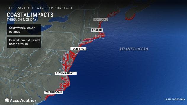
Regardless of the exact coverage of severe weather, the potent storm will spread heavy rainfall across the Southeast, raising flooding concerns across the region. Coastal areas along the Southeast can also experience strong wind gusts into early Monday, which can cause dangerous surf and coastal inundation.
Along the Carolinas, out into the Atlantic and farther north along the coast in the mid-Atlantic and New England, wind gusts can range between 40 and 60 miles per hour, resulting in power outages across the area through Monday.
Want next-level safety, ad-free? Unlock advanced, hyperlocal severe weather alerts when you subscribe to Premium+ on the AccuWeather app. AccuWeather Alerts™ are prompted by our expert meteorologists who monitor and analyze dangerous weather risks 24/7 to keep you and your family safer.
