
Potent storm to drench Northwest, trigger severe weather in Midwest


Following a dry and sunny last day of May, an unusually strong and wet storm for early June will roll into the Northwest later this weekend, prompting travel problems and disruptions to daily activities. AccuWeather meteorologists warn the storm will pack strong winds over the mountains and trigger severe weather for parts of the northern Plains and Upper Midwest next week.
 |
The period from late May to June marks a time of the year where powerful storms from the winter are a thing of the past and weaker systems continue to roll in from the Pacific Ocean with lesser impact. However, a significantly more potent storm, packed with moisture, will arrive later this weekend and push inland early next week.
"The upcoming storm will unleash the equivalent of an entire month's worth of rain for June over much of the Northwest," AccuWeather Senior Meteorologist Tom Kines said, "And, in some cases perhaps even more."
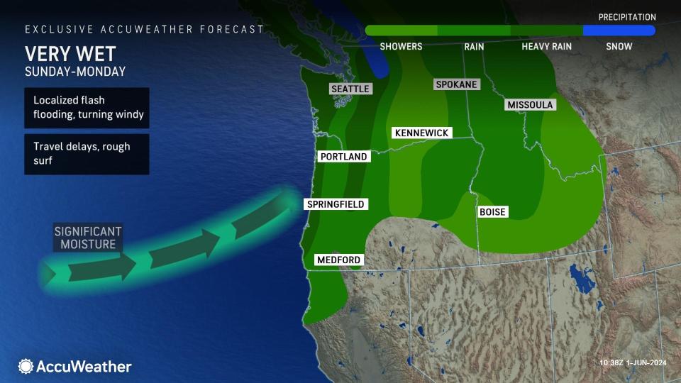
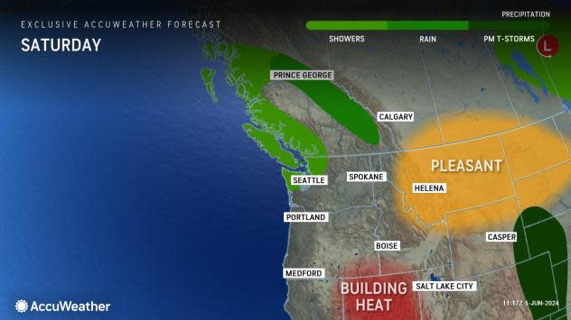
Spotty showers are in store as the storm's leading edge of moisture arrives in coastal Washington on Saturday before the main body of the storm moves in.
The storm will unleash up to several inches of rain on much of Washington, northern and western Washington, northern Idaho and the northwestern parts of California and Montana from Sunday to Monday.
 |
"Widespread rain of 2-4 inches will fall on the central Oregon coast on north as well as the central and northern Oregon and Washington Cascades with pockets of 4-8 inches of rain on the west-facing slopes of the Olympics and Coast Ranges from central Oregon on north," AccuWeather Senior Meteorologist Dave Houk said, "Along the Interstate 5 corridor of Washington and northern Oregon, 1-2 inches of rain is likely to fall."
The bulk of the rain in Seattle and Portland, Oregon, will fall from Sunday through Sunday night with leftover showers on Monday.
Rivers draining from the Cascades to the coast will be rising with quick flow rates. While no major flooding is anticipated, minor flooding can occur in the most susceptible areas, especially along the smaller streams, Houk said.
 |
Rainfall east of the Cascades will vary significantly, but some of the west- and southwest-facing slopes of the various ranges in eastern Oregon and Washington to northern Idaho and northwestern Montana, as well as the Coast Ranges in part of northern California, can pick up an inch or two from Sunday to Monday night.
The storm will bring snow to the high country but not down to most major pass levels. Snow is not uncommon up high in early June. However, rain and fog, with increasing winds, will create slow travel over the passes.
"On Monday, snow levels will get as low as 5,000 feet," Houk said, "There will be 6-12 inches of snow in the Cascades from northern Oregon through Washington above 7,000 feet, with a few inches down to 6,000 feet late Sunday night through Monday."
From Monday to Tuesday, the storm is also likely to produce snow on the highest elevations of the Rockies in western Montana and Idaho. Those venturing into the high country of National Parks should be prepared for changing weather conditions, including mixed rain and snow as well as strong winds.
Deciduous trees have leafed out and may face more stress than when free of leaves during winter storms. As a result, strong wind gusts from the storm may knock down more trees or large tree limbs than typically occurs during some winter storms.
"Winds initially won't be as strong as we see with some October and November storms, but there will be 40-50 mph gusts along the Washington and Oregon coasts and then also in some of the spots east of the Cascades," Houk said. Localized wind gusts may approach 60 mph.
Winds strong enough to cause difficult travel, tree damage, and power outages are likely to extend inland across portions of Idaho, Montana, and the Dakotas early next week.
 |
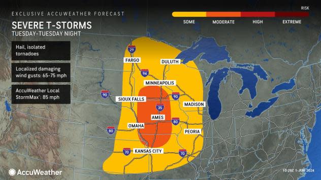
Along with the likelihood of gusty winds over the northern Rockies, the same storm system will spark heavy, gusty and locally severe thunderstorms in the region. The thunderstorm potential will ramp up east of the Rockies.
June to July is the time of the year when the severe weather threat generally expands northward in the U.S. and this storm will likely demonstrate just that.
The storm will interact with surging warmth and moisture over the northern Plains and Upper Midwest early next week.
 |
The result will be an eruption of thunderstorms that will quickly turn heavy, gusty, and then severe on Tuesday from portions of Kansas and Missouri northward to much of Iowa, Minnesota, and Wisconsin, central and eastern Nebraska, the eastern Dakotas, and northwestern Illinois.
A wide range of severe weather is likely from the thunderstorms on Tuesday, including high winds, large hail, and even a few tornadoes. The AccuWeather Local StormMax™ wind gust is currently 85 mph for the event on Tuesday.
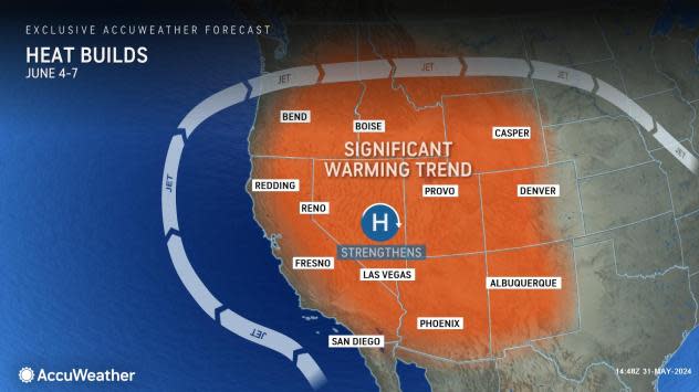
In the wake of the storm, a large area of high pressure will build at most levels of the atmosphere over the western United States next week.
 |
Some of the heat pent up in Mexico will build northward. Widespread highs in the 80s to near 90 F are in store for the interior Northwest, with highs in the 70s common for the immediate Pacific Coast.
Want next-level safety, ad-free? Unlock advanced, hyperlocal severe weather alerts when you subscribe to Premium+ on the AccuWeather app. AccuWeather Alerts™ are prompted by our expert meteorologists who monitor and analyze dangerous weather risks 24/7 to keep you and your family safer.
