
Parade of storms to bring more rain, high-elevation snow to the Northwest


Wet weather will continue across the Northwest early this week, AccuWeather meteorologists say, as an active jet stream brings another storm ashore.
As AccuWeather accurately predicted, the first two storms brought heavy rain and gusty winds to the Northwest. The initial storm moved through the region Wednesday and Thursday, bringing heavy downpours and strong winds. The next storm that moved through Friday night through Saturday brought another round of heavy rain and gusty winds to the region.
As of Monday morning, 3.07 inches of rain has fallen at Seattle-Tacoma International Airport, with 3.01 inches so far in Portland, Oregon. Just over an inch of the total rainfall in Portland was reported over the past day. Amounts upwards of 8 inches have also been observed so far in parts of the Olympic Mountains and the Cascades.
Many coastal areas across the Northwest including Hoquiam, Washington, have experienced gusty winds with both storms. Winds gusted to as high as 62 mph during the first storm and 56 mph during the second storm at Hoquiam.
 |
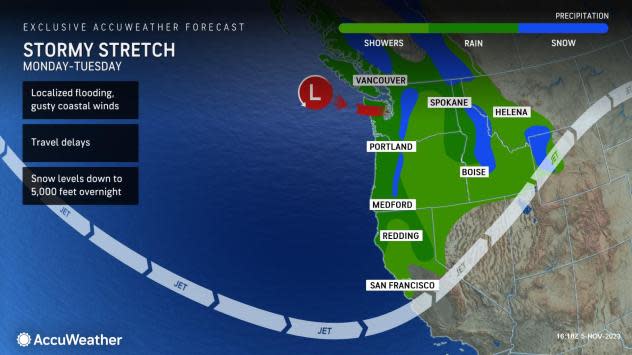
After a damp and dreary end to the weekend, the next storm will push its way into the region at the start of the week.
"Another storm will push into the Pacific Northwest later on Monday which will bring another bout of moderate rainfall and gusty coastal winds," says AccuWeather Meteorologist Joe Bauer.
Individuals will need to be cautious of ponding on roadways, flooding in low-lying areas and smaller streams overflowing their banks as a result of continued rainfall across the region.
Have the app? Unlock AccuWeather Alerts™ with Premium+
Unlike the previous storm, colder air is expected push into the area as the storm moves through the region dropping snow levels through Tuesday. Snow levels can drop to around 5,000 feet, which can bring accumulating snow to some of the higher passes across the Northwest.
Showers and drizzle can linger across the Northwest Tuesday before a brief stretch of dry weather midweek.
 |
Total rainfall from all three storms through Tuesday is expected to average between 8 to 12 inches across portions of west-facing slopes of the Olympics, Cascades and Coast Ranges with an AccuWeather Local StormMax™ of 15 inches. Meanwhile, Portland, Oregon, and Seattle can expect total rainfall through Tuesday between 2 to 4 inches.
Showers and drizzle can linger across the Northwest Tuesday before dry conditions set in midweek.
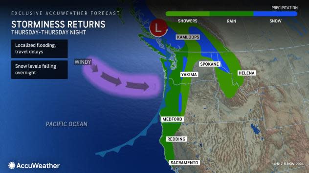
Looking ahead, the stint of dry weather won't last for long as forecasters say another storm will approach the region later in the week bringing another round of heavy rain, gusty winds and mountain snow Thursday and Thursday night.
 |
"Snow levels are expected to be around 6,000 feet during the daytime before dropping to 4,000 feet overnight and may drop even lower in parts of the Cascades," adds Bauer.
Individuals planning on any travel across mountain passes including Snoqualmie Pass should be prepared for slippy and slow travel late week.
Want next-level safety, ad-free? Unlock advanced, hyperlocal severe weather alerts when you subscribe to Premium+ on the AccuWeather app. AccuWeather Alerts™ are prompted by our expert meteorologists who monitor and analyze dangerous weather risks 24/7 to keep you and your family safer.
