
Pacific storm train to bring one-two punch of wet weather and renewed flooding this weekend


California residents have received a welcome break from rain and storms following the deadly mudslides that tore through southern parts of the state earlier in the month. The floodgates of the Pacific Ocean will again be flung open as AccuWeather meteorologists project a storm duo to provide a one-two punch of wet weather this weekend into early next week.
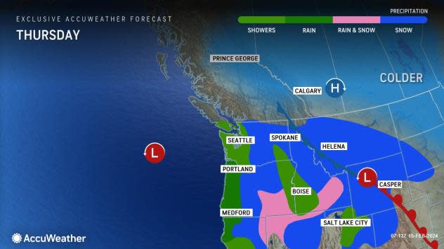
A brief storm will break the dry stretch for Northern California around midweek.
"After several days of mostly dry weather, there will be a quick but heavy shot of rain moving through northern parts of the state through Thursday," AccuWeather Senior Meteorologist Heather Zehr said.
 |
"Some places along the central coast, near San Francisco, may pick up 0.50-1 inch of rain with this first event, with 2-4 inches possible along the Northern California coast up through coastal Oregon," Zehr added.
Areas of Southern California that received historic rain amounts from the atmospheric river last week will be spared from any precipitation with this round. However, AccuWeather experts say the next pair of storms will take a path farther to the south, increasing the risk of hard-hit areas receiving additional rainfall.
 |
The week will end on a dry note before the first of the two storms arrives along the West Coast over the weekend.
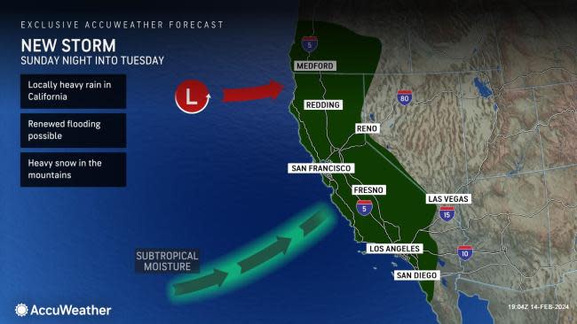
"This first storm in the two-part rain threat will likely bring the heaviest precipitation to some of the same areas that got hit at midweek, especially the Redwood coast of Northern California, which can increase the risk of flooding," Zehr said.
 |
How far south precipitation gets in California will depend on the storm's track, but the latest indications point toward the Los Angeles basin receiving no more than a stray shower or two over the weekend.
"Parts of Southern California will likely get heavier rain from the second, more impactful storm which is expected to arrive early next week," Zehr said.
This storm, expected to move in on Sunday, Feb.18, will take a path farther to the south than its predecessors, allowing it to tap into more tropical moisture. There is the potential for at least several inches of rain to fall along portions of the Southern California coast and nearby high terrain.
"This can affect areas around the Los Angeles basin and northward, some of the hardest-hit areas from the recent atmospheric river event during the first week of February," Zehr said.
 |
Even with over a week of dry weather ahead of the next rain event, the wet and unstable nature of the soil plus the additional rainfall can create a dangerous mudslide risk.
AccuWeather's long-range forecasting team, led by Senior Meteorologist Paul Pastelok, expects the storm track to shift farther north heading into late February.
Want next-level safety, ad-free? Unlock advanced, hyperlocal severe weather alerts when you subscribe to Premium+ on the AccuWeather app. AccuWeather Alerts™ are prompted by our expert meteorologists who monitor and analyze dangerous weather risks 24/7 to keep you and your family safer.
