
Multiday deluge of rain underway across the South

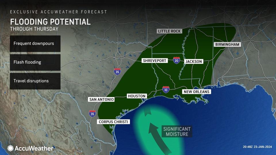


A multi-day deluge of rain and thunderstorms is aiming at the South this week, raising concerns for flooding across the region. The weather pattern across the central and eastern United States will shift as moisture funnels out of the Gulf of Mexico and meets up with a train of storms rolling out of the Southwest.
 |
This pattern shift has already shown signs of being active across eastern Texas, Louisiana and Arkansas when a round of steady, bone-chilling rain moved through the region. As the region remained entrenched within sub-freezing conditions from this past weekend, many areas across northern Texas, Oklahoma and Arkansas experienced a round of dangerous freezing rain, which snarled traffic and prompted numerous flight cancellations and delays on Monday.
Persistent winds flowing out of the Gulf of Mexico this week will soon make the freezing conditions a memory for residents in places like Houston, New Orleans and Memphis, where there will be a major upward trend of temperatures in the coming days. Accompanying the warmth and out-of-season humidity level will be the continued threat of rounds of rain and thunderstorms.
Not only will the ingredients for heavy rain be in place across the South, but conditions will also become prime for thunderstorm activity. During Tuesday night, many of the same places across eastern Texas that received heavy rain from Monday were in the risk zone for severe thunderstorms.
 |
Flash flooding may ultimately be the most widespread risk in places such as College Station, Waco and Tyler, Texas, through Wednesday, but some of the most fierce thunderstorms can also produce damaging wind gusts.
Some of these thunderstorms could be packing wind gusts that can approach the AccuWeather Local StormMax™ of 80 mph, which could easily topple trees and lead to localized power outages. Given that the ground will also be saturated from previous rounds of rain, there is an elevated risk that wind gusts could blow over and uproot trees.
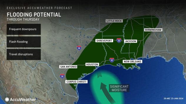
The risk of drenching thunderstorms will continue right into Wednesday across the South, expanding eastward into the lower Mississippi River Valley. While the thunderstorms will pose a threat of localized damaging wind gusts and flash flooding across the region, there is one silver lining to the forecast.
"The rain will also be welcome for the lower Mississippi Valley with portions of northern Louisiana to northwestern Mississippi within exceptional drought conditions," AccuWeather Meteorologist Joe Bauer said.
 |
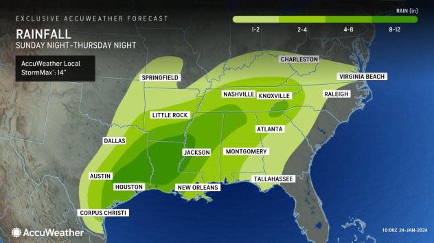
A widespread area across the South is expected to tally up rainfall totals that will exceed an inch in the coming days, with even higher amounts focused along a zone from eastern Texas through much of Louisiana, southern Arkansas, Mississippi, northern Alabama and southern Tennessee. Within the zone of heaviest rain, the potential exists for rainfall totals that can exceed 4 inches before the end of the week.
 |
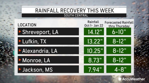
In areas where repeated rounds of thunderstorms track over the same location, a few neighborhoods could even approach the AccuWeather Local StormMax™ of a whopping 14 inches of rainfall. This seems most likely in far-eastern Texas and northern Louisiana.
When comparing the latest drought monitor with the exclusive AccuWeather forecast rainfall map, the upcoming deluge of rain will undoubtedly put a dent in some of the drought conditions across the region.
 |
Rain is forecast to shift into the Southeast for Friday before another storm gathers in the Lower Mississippi River Valley late Friday night or Saturday, bringing yet another round for the already drenched area for the end of the week.
A brief reprieve from the wet weather is expected by early next week when drier conditions are expected to take place for at least a few days.
Want next-level safety, ad-free? Unlock advanced, hyperlocal severe weather alerts when you subscribe to Premium+ on the AccuWeather app. AccuWeather Alerts™ are prompted by our expert meteorologists who monitor and analyze dangerous weather risks 24/7 to keep you and your family safer.
