
How much rain is coming to L.A. County over the next week? A lot

If your rain gutters are overflowing now, just wait.
Forecasters say a second storm fueled by an atmospheric river will hit California next week, roughly doubling the amount of rain falling Thursday on Los Angeles and surrounding areas.
All told, the city of L.A. is expected to receive almost 5.9 inches from the storm that started Wednesday and the more enduring one that's expected to peak on Sunday and Monday, the National Weather Service said this week. The totals within L.A. County range from 2.7 inches in Lancaster to 10.2 inches in Pine Mountain.
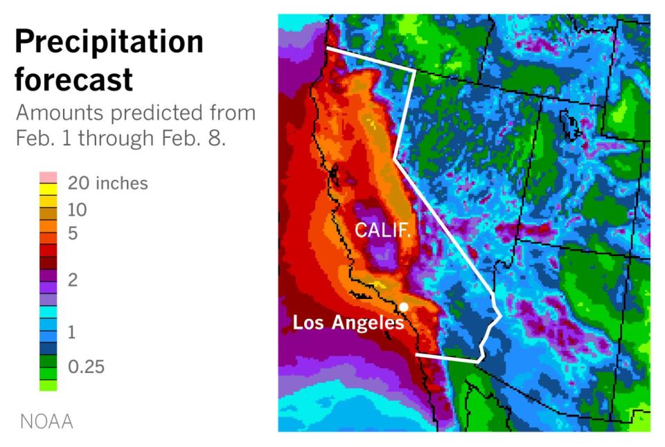
For those of you keeping track at home, the amount of rain expected for L.A. is about three times as much as the city received in January. And it's more than the city saw in all of 2020-21, according to the Los Angeles Almanac.
Here are the weather service's projections for rainfall for selected cities in the region:
Fillmore: first storm 3 inches, second storm 5.3 inches, 8.3 inches total
Lancaster: first storm 0.8 inches, second storm 1.9 inches, 2.7 inches total
Long Beach: first storm 1.9 inches, second storm 3.5 inches, 5.4 inches total
Los Angeles: first storm 2 inches, second storm 3.9 inches, 5.9 inches total
Northridge: first storm 1.9 inches, second storm 4.2 inches, 6.1 inches total
Ojai: first storm 3.3 inches, second storm 6.5 inches, 9.7 inches total
Oxnard: first storm 2 inches, second storm 4.8 inches, 6.7 inches total
Pasadena: first storm 3 inches, second storm 4.5 inches, 7.5 inches total
Paso Robles: first storm 0.9 inches, second storm 2.2 inches, 3.1 inches total
San Luis Obispo: first storm 1.8 inches, second storm 3.4 inches, 5.2 inches total
Santa Barbara: first storm 2.5 inches, second storm 5.7 inches, 8.2 inches total
The weather service offered more general projections for snowfall, saying the first storm could bring 8 to 16 inches of snow to elevations above 7,000 feet. As for the second storm, the service said, "significant and hazardous" snowfall will be possible above 6,000 feet through Monday night, with lesser amounts possible at lower elevations in the mountains by Tuesday or Wednesday.
Forecasters expect the first storm to abate Thursday afternoon, although San Luis Obispo and the mountains could see more precipitation Friday.
The volume dumped by the second storm is expected to be significantly greater because the storm system isn't in as big a hurry to leave Southern California. The system is expected to stall "from around Point Conception south," the weather service said, but that spot "could easily shift 50 to 100 miles either direction so there still is some uncertainty." Nevertheless, it said, "this system will likely produce 24 to 36 hours (or more) of continuous rain."
This story originally appeared in Los Angeles Times.

