Severe storms lash central and eastern US, dumping rain, softball-sized hail and threatening tornadoes
Parts of Texas all the way to Illinois were drenched Monday evening as severe thunderstorms marched through the central and eastern US, dumping hail larger than softballs in some areas and unleashing fierce winds of more than 70 mph.
The storms are also threatening large swaths of the region with dangerous tornadoes, and at least three tornado watches were issued for Monday night, covering more than 6 million people.
One covers much of Oklahoma – including Oklahoma City and Tulsa – and parts of northern Texas through Monday night, according to the Storm Prediction Center. A second tornado watch was issued for southeastern Kansas and western Missouri through late Monday night, according to the prediction center. A third tornado watch is in effect for eastern Missouri and central Illinois through midnight.
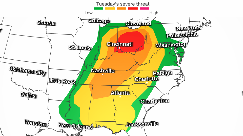
And there’s more severe weather expected Tuesday, when the threat shifts east and places parts of the Ohio Valley under a Level 4 of 5 risk, where a “substantial severe weather outbreak” is possible, according to the Storm Prediction Center.
Monday: high winds, huge hail, strong rain
By Monday night, millions of Americans were under some kind of severe weather alert – including more than 17 million people across parts of the Ohio Valley who were under flood watches.
Here’s what else to know.
• More than 85 storm reports occurred by Monday night across the central US, according to the Storm Prediction Center – a number that is expected to increase in the night hours as storms continue to lash the region.
• There have been more than 30 high wind gust reports so far, the majority of which were in Texas. In the small Texas town of Albany, a wind gust of 88 mph was recorded.
• There have been more than 50 large hail reports throughout Monday, with the largest hail recorded in Texas. The community of Briar reported a staggering hail size of 4.5 inches.
A moderate risk for severe storms – a level 4 out of 5 – was dropped by the Storm Prediction Center Monday evening, but an enhanced risk for storms – a 3 out of 5 – remain Monday night, stretching from northeast Texas to southwest Ohio. Despite the drop in storm risk, the threat of strong tornadoes is still ongoing.
Research shows nighttime tornadoes are more than twice as deadly as daytime tornadoes. Tornadoes are difficult to spot in the dark and are more deadly because many people are sleeping.
Thunderstorms will rumble farther east into parts of the mid-Atlantic overnight, but the threat for severe impacts will become more isolated in nature.
Tuesday: Substantial severe weather outbreak possible

The severe thunderstorm threat will march east on Tuesday and include areas from the Gulf Coast through the Ohio Valley. Thunderstorms could be ongoing Tuesday morning in parts of the Midwest and Ohio Valley, but are forecast to taper off quickly and make way for another round of dangerous storms in the afternoon and evening.
“A potentially substantial severe weather outbreak is evident for Tuesday afternoon and evening,” the Storm Prediction Center warned Monday.
Tuesday’s risk for severe storms was upgraded to a Level 4 of 5 in much of Ohio and parts of Indiana, Kentucky and West Virginia on Monday afternoon. Intense, long-track tornadoes may develop in the area, according to the center. Very large hail and destructive winds are also possible with storms in the area.
A Level 3 of 5 risk for severe thunderstorms with damaging wind gusts, hail and a few tornadoes is in place from northern Alabama to northern Ohio and western Pennsylvania. Nashville and Louisville, Kentucky, are within this area of risk. Surrounding states are under a Level 2 of 5 risk Tuesday.
Cold air pushing into the northern edge of the storm will change rain over to snow and a wintry mix later Tuesday in parts of the Midwest and Great Lakes. Rain and snow showers will continue in parts of both regions through Thursday.
Cities including Chicago could even see a few flakes, but little accumulation of snowfall is expected. The highest snowfall totals are expected across the parts of northern Michigan and northeastern Wisconsin, where snowfall of 6-12 inches is possible Tuesday afternoon through Wednesday afternoon. Some parts of northern Michigan can see snowfall last into Thursday and could see snowfall totals over a foot.
Winter-like weather will shift into the interior Northeast on Wednesday. Higher elevations of the interior Northeast including the Green, White and Adirondack Mountains could pick up close to a foot of snow through Thursday.
The major cities across the Northeast, including New York City, Boston and Philadelphia, are currently forecast to see rain.
CNN’s Sara Smart contributed to this report.
For more CNN news and newsletters create an account at CNN.com


