
Tornado warning - live news: 40 million in US South warned of ‘rare’ twister outbreak amid stormy weather
More than 40 million people in the southern United States were in the path of a rare, dangerous storm system on Tuesday that is highly likely to spawn tornadoes.
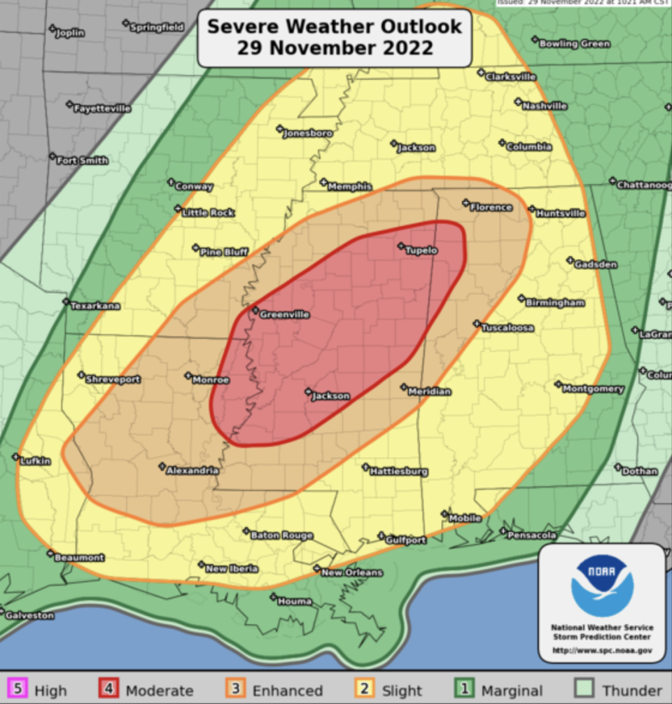
Parts of Alabama, Arkansas, Louisiana and Tennessee were at risk from strong tornadoes that could track for miles on the ground, forecasters warned, as well as severe flooding and tennis ball-sized hailstones. Affected cities could include New Orleans, Memphis, Nashville, and Birmingham.
“Multiple rounds of severe thunderstorms -- some capable of long-tracked tornadoes with EF3+ damage potential -- will be possible this afternoon into tonight over parts of the lower Mississippi Valley region and Mid-South,” the Norman, Oklahoma-based Storm Prediction Center said.
Tornadoes with an EF3 rating on the Enhanced Fujita tornado scale can produce wind gusts of up to 165 mph (266 kph).
Key Points
People from southeastern Texas eastward to Georgia, and northward to Indiana and Illinois are under a threat of severe weather
Families in the area are being urged to take safety measures
Flash flooding risk in some areas
‘Pea-sized’ hail and tornado warning in Alabama
20:09 , Louise Boyle
A tornado warning was put in place until 2.30pm (central time) in the small towns of Fruitdale and Yellow Pine, Alabama.
More than 1,350 people live in the area and two schools are located there, the National Weather Service reported.
Tornado Warning including Fruitdale AL and Yellow Pine AL until 2:30 PM CST pic.twitter.com/0YlWn8vKa9
— NWS Tornado (@NWStornado) November 29, 2022
Tornado watch stretches across the South
19:41 , Louise Boyle
A tornado watch has been issued for parts of Arkansas, Louisiana and Mississippi until 7pm (central time) on Tuesday.
A tornado watch has been issued for parts of Arkansas, Louisiana and Mississippi until 7 PM CST pic.twitter.com/xkEHj0lsrl
— NWS Tornado (@NWStornado) November 29, 2022
Rare warnings
19:12 , Louise Boyle
It’s rare that federal forecasters warn of major tornadoes with the potential for carving damages across long distances, but they are doing so in Tuesday’s forecasts, the Associated Press reported on Tuesday.
“Multiple rounds of severe thunderstorms -- some capable of long-tracked tornadoes with EF3+ damage potential -- will be possible this afternoon into tonight over parts of the lower Mississippi Valley region and Mid-South,” the Norman, Oklahoma-based Storm Prediction Center said.
Tornadoes with an EF3 rating on the Enhanced Fujita tornado scale can produce wind gusts of up to 165 mph (266 kph).
Forecasters warned of the potential for strong tornadoes that could stay on the ground for long distances in parts of the South, as well as flooding rains and hail the size of tennis balls.
More than 25 million people will be at risk as Tuesday’s potent storm system moves across a region stretching from east Texas to Indiana and Georgia. The national Storm Prediction Center said in its latest storm outlook that affected cities could include New Orleans; Memphis and Nashville in Tennessee; and Birmingham, Alabama.
Parts of Louisiana and Mississippi will be at the highest risk for strong storms Tuesday afternoon and evening, with the possibility of severe weather continuing into Wednesday and moving into Alabama.
AP
How to prepare
19:00 , Louise Boyle
Dr Rick Knabb, a hurricane expert at The Weather Channel, shared tips on how to stay safe during the severe weather.
“Tornado watch doesn’t mean wait until a warning to take any action,” he tweeted “There are things to do right now so you’re ready to quickly take cover in safest room when warning issued. First and foremost get out of mobile homes, off roads, into sturdy building now.
Tornado watch doesn’t mean wait until a warning to take any action. There are things to do right now so you’re ready to quickly take cover in safest room when warning issued. First and foremost get out of mobile homes, off roads, into sturdy building now. https://t.co/EkiqXRxwf7 pic.twitter.com/pwkaozSr8W
— Dr. Rick Knabb (@DrRickKnabb) November 29, 2022
The regions at risk
18:50 , Louise Boyle
The most recent update from the National Weather Service Storm Center in Norman, Oklahoma, in the heart of Tornado Alley, provided the list of the areas to be prepared for severe weather.
Strong tornadoes, very large, “baseball-sized” hail, and severe wind gusts are forecast from Tuesday afternoon into tonight in Northern Alabama, Northeast Louisiana, Southeast Arkansas, Southern Tennessee.
Watch: Forecasters warn of extreme weather on the way
18:39 , Louise Boyle
Tornado warnings begin in Louisiana
18:03 , Louise Boyle
Tornado warnings started to pop up early on Tuesday afternoon from the National Weather Service’s official Twitter account
Among the first were for the tiny towns of Mamou, Pine Prairie and Reddell in Evangeline Parish, Louisiana until 12.15pm (Central Time).
Tornado Warning continues for Mamou LA, Pine Prairie LA and Reddell LA until 12:15 PM CST pic.twitter.com/X34FTfe4AE
— NWS Tornado (@NWStornado) November 29, 2022
Why it’s so hard to know if tornadoes are caused by climate change
17:40 , Louise Boyle
In December 2021, a powerful tornado outbreak across six US states left dozens of people dead.
At the time, I wrote about the difficulty of linking these events to the climate crisis.

Why it’s so hard to know if the Kentucky tornado was caused by climate change
Meteorologist posts shelter locations
16:48 , Sam Webb
Thank you as well to the meteorologists who have helped share the information I have developed on #tornado shelters. There are hundreds of them in the region that counties will likely open once the threat begins.
The map link is pinned to my profile. #MSwx #ALwx #TNwx pic.twitter.com/hY2fA7F9Cu— Craig Ceecee (@CC_StormWatch) November 28, 2022
What is a tornado?
16:39 , Sam Webb
Tornadoes are whirling, vertical air columns that form from thunderstorms and stretch to the ground. They travel with ferocious speed and lay waste to everything in their path.
Thunderstorms occur when denser, drier cold air is pushed over warmer, humid air, conditions scientists call atmospheric instability. As that happens, an updraft is created when the warm air rises. When winds vary in speed or direction at different altitudes — a condition known as wind shear — the updraft will start to spin.
These changes in winds produce the spin necessary for a tornado. For especially strong tornadoes, changes are needed in both the wind’s speed and direction.
More from the Independent on tornadoes and how the climate crisis makes them worse here.
Still some risk tomorrow
16:24 , Sam Webb
According to weather.com, the potential for severe weather will decrease on Wednesday. However, some parts of the Southeast could see one to two inches of rain and flash flooding is possible in areas where too much rain falls too quickly.
Meteorologist explains threat levels
16:00 , Sam Webb
Meteorologist Craig Ceecee has outlined what the storm categories mean:
What do the storm categories mean? They mean the confidence level, as well as the expected amount of reports, of severe storms.
Don't assume you're not at risk - or let the guard down - if you're outside the maximum threat. The #tornado threat expands well outside the peak area. pic.twitter.com/XnLSW18SWJ— Craig Ceecee (@CC_StormWatch) November 29, 2022
He added: “If you can’t get to your safe place from home, or up and out, in 5 minutes - especially if in a mobile home or weaker structure - you should spend the time under #tornado threat tomorrow somewhere else (with family/friends, at work or at a shelter).”
Safety plan is ‘imperative'
15:47 , Sam Webb
Meteorologist for @WCBINEWS Jackson Chastain tweeted: “This is what we are up against. A Tornado Watch is likely by early this afternoon.
“The window is large, as is the potential for several long-track tornadoes. It is imperative that you have a safety plan going into this evening.”
This us what we are up against. A Tornado Watch is likely by early this afternoon. The window is large, as is the potential for several long-track tornadoes. It is imperative that you have a safety plan going into this evening. #mswx #alwx pic.twitter.com/ZplIqr1LLm
— Jackson Chastain (@jchastainwx) November 29, 2022
Take picture for insurance. residents urged
15:43 , Sam Webb
The Mississippi Emergency Management Agency is urging homeowners to photograph their property before the storm hits for insurance purposes. It tweeted: “We encourage Mississippians to take photos of their home BEFORE the storms. These photos can be used for insurance purposes and/or possible assistance if your home is damaged in the storm.”
⚠️SEVERE WX FOR TODAY (11/29)⚠️
The NWS updated the risk map for today's wx. Storms, hail, damaging winds, and tornadoes are all possible. STAY INFORMED!
📲Set alerts to LOUD to wake you
🏡 Know your safe place
💡Prepare for power outages
🚗Stay off the roads if possible pic.twitter.com/aVHbnuOgF6— msema (@MSEMA) November 29, 2022
‘Make decisions quickly'
15:40 , Sam Webb
Bill Bunting, chief of forecast operations at the Storm Prediction Center, told CNN Weather, said: “Another challenge with nighttime tornadoes, especially in the fall and winter, is that storms typically move very quickly, at times 50 or 60 mph.
“This means that you must make decisions quickly and take shelter based on information contained in the severe thunderstorm or tornado warning, and not wait until the storm arrives,” he added.
Hail and strong wind also a threat
15:39 , Sam Webb
A total of three million people across much of Mississippi and parts of western Alabama, southwestern Tennessee, eastern Arkansas, northern Louisiana, and a small part of eastern Texas are at risk of hail, strong wind, and tornadoes.

