A new map shows which Metrolinx stations are accessible. Advocates say they'd rather have accessible transit

Metrolinx has introduced a map showing accessibility features at it stations to make it easier for people with disabilities to navigate transit across Greater Toronto and Hamilton Area — but some advocates say that does nothing to remove barriers.
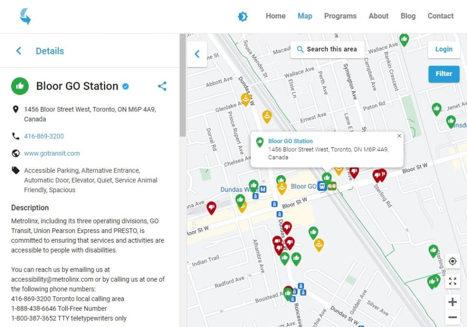
The digital map was created in partnership with AccessNow, an app that allows users to rate and share information about public places based on how accessible they are.
Under the new partnership, Metrolinx is providing information about GO Transit and UP Express stations, like whether there are elevators, audio aids, or PRESTO machines with Braille, so that users can plan transit rides based on their needs.
AccessNow founder Maayan Ziv says while Metrolinx will keep that information updated, the map will also rely on the input of the people who use it.
"It's actually a collaboration between people with lived experience of disabilities, who were directly involved in assessing the experiences that they have at Metrolinx stations," she said.

On the map, Metrolinx stations with a blue check mark have accessibility information deemed up to date and accurate by AccessNow and Metrolinx. (AccessNow)
Feedback from users is then shared with Metrolinx, she says, which gives the agency a better idea of what accessibility gaps need to be addressed.
'We should have fully accessible transit'
But those gaps are still there, and some advocates say a map isn't enough.
"It's helpful to know if there are accessibility features," said David Lepofsky, chair of the Accessibility for Ontarians with Disabilities Act Alliance. "But this is all symptomatic of a huge problem. We should have fully accessible transit stations in all locations."

David Lepofsky is Chair of the Accessibility for Ontarians with Disabilities Act Alliance. (Tina Mackenzie/CBC)
Aside from that, Lepofsky says, even if the map says there's a feature like an elevator at a station, there's no guarantee that elevator will be working.
Lepofsky, who is blind, says transit in the GTHA is currently a two-tiered system with a far worse quality of service available to people with disabilities. He says gaps in service don't need to be identified so people can work around them — they should be fixed.
"So that we don't need this information at all."
App won't help meet accessibility target: advocate
Ontario Disabilities Coalition spokesperson Anthony Frisina says the map is a step in the right direction, but like Lepofsky, he says there's far more work to be done, especially in light of the province's 19-year-old commitment to make Ontario fully accessible by 2025.
He says an accessibility map may make commutes easier to plan, but he'd like to see a transit system accessible enough that people with disabilities don't have to plan around anything at all.
"The biggest challenge for commuters that require accessible transit is really the time management: having to book in advance, not being able to really do anything spot, spontaneously," Frisina said. "We need to get from point A to point B when we need to, not when the system allows us to."
Metrolinx says app just one part of accessibility work
Metrolinx declined to provide an interview for this story. But in an email, spokesperson Andrea Ernesaks says the agency is working to improve accessibility in its service in other ways. That includes the use of braille in stations and more space on buses for service animals.
Metrolinx also consults with people with disabilities, Ernesaks says, and has a standing accessibility advisory committee that has helped implement a universal design standard for all Metrolinx projects since 2019.
"The app will improve the customer experience by providing up-to-date trip planning information," Ernesaks wrote, "while also allowing us to receive direct feedback from customers through accessibility reviews of our GO and UP stations."


