
Learn 10 Types of Clouds and How to Identify Them
When's the last time you went cloud-gazing? Sinking, rising, spreading, changing—there’s always something exciting happening to the clouds overhead. The big puffy ones—what are they called? And the thunderstorm clouds—what are their names? Read on to learn how to identify the clouds you see every day. It’s not just a fun exercise; it’s practical too, because the types of clouds nearby can also help forecast the weather.
Where did the clouds get their names? From Luke Howard, an amateur meteorologist who studied them at the turn of the 19th century. As described by the National Weather Service, “While clouds appear in infinite shapes and sizes, they fall into some basic forms. From his Essay of the Modifications of Clouds (1803), Luke Howard divided clouds into three categories: cirrus, cumulus and stratus.” In addition to those three main types, Howard also designated compound terms for the in-between, or intermediate forms, including “cirrocumulus,” “stratocumulus,” and “cirrostratus.” These terms take into account clouds’ ever-changing nature. Howard also coined “nimbus” or “nimbo-form,” terms used to describe precipitation-bearing clouds, which you’ll recognize as rain clouds. When naming the cloud patterns he saw, Howard drew inspiration from Latin. Each of the terms he used described the types of clouds he observed in the sky.
Today, 10 basic cloud forms are recognized, all of which owe a debt to Howard's nomenclature. Some are low-level clouds that exist below 6,500 feet, such as cumulus, stratus, and stratocumulus. Others are mid-level—including altocumulus, nimbostratus, and altostratus—and appear between 6,500 and 20,000 feet. The cloud forms that appear highest in the sky are cirrus, cirrocumulus, and cirrostratus, and they appear above 20,000 feet. Some clouds can be challenging to identify because they appear together or shift rapidly from one form to another. Read on for more information on the 10 basic cloud types and photos to help identify them.

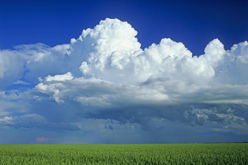
Cumulus Clouds
When you think of a blue sky dotted with big, puffy, clearly defined clouds, you’re likely picturing fluffy cumulus forms. The name comes from the Latin “cumulo-”, meaning “heap” or “pile.” These clouds develop as dense, individual forms with a pillowy appearance.

Stratus Clouds
“Stratus” is Latin for “layer” or “sheet,” and it describes clouds which stretch out uniformly over the sky. Stratus clouds are low-lying and appear as though stretched in a thin, grey layer or in separated sheets overhead.

Stratocumulus Clouds
Stratocumulus clouds combine the appearance of stratus clouds and cumulus clouds and occur as a puffy, fluffy layer stretched out in a sheet overhead. When clustered, they sometimes take on the appearance of honeycomb.
Cumulonimbus Clouds
Cumulonimbus clouds indicate impending precipitation (hence "nimbus"), as they are most closely associated with thunderstorms and can forecast severe weather. Cumulonimbus clouds often occur as low-level clouds, but they can also stretch up very high in the sky, usually with a form that flattens out at the very top.

Altocumulus Clouds
This form occurs as a mid-level cloud and appears patchy and puffy in the sky; tt sometimes looks like rolls lined up next to each other. The name altocumulus comes from the Latin "altus," meaning "high," and "cumulus," meaning "heaped" or "piled."

Nimbostratus Clouds
This cloud form appears as foggy-looking layers or sheets in the sky, and it occurs with precipitation (i.e. "nimbo-"). According to Weather.gov, “Resulting from thickening altostratus, this is a dark gray cloud layer diffused by falling rain or snow. It is thick enough throughout to blot out the sun.”

Altostratus Clouds
Altostratus clouds form as layers of thin, gray clouds stretching out in sheets across the sky. They are thinner and more transparent than nimbostratus clouds, which sometimes have a similar appearance.

Cirrus Clouds
Wispy clouds found high in the sky are known as cirrus clouds. Cirrus is Latin for “tendril,” "curl," or “hair.” According to Weather.gov, Cirrus clouds are “detached clouds in the form of white, delicate filaments, mostly white patches or narrow bands. They may have a fibrous (hair-like) and/or silky sheen appearance.”

Cirrocumulus Clouds
This cloud form has the separation of cirrus clouds and the fluffy appearance of cumulus clouds. Cirrocumulus forms appear as small, separated puffy clouds dotting the sky, and they sometimes look like ripples.

Cirrostratus Clouds
These clouds are made up of icy crystals and form as thin sheets very high in the sky. They are nearly transparent, very uniform, and sometimes hard to see with the naked eye. They take on the appearance of a wispy white veil, through which you can see celestial objects, such as the sun, moon, and stars.
For more information about clouds and their names, read Richard Hamblyn’s The Invention of Clouds: How an Amateur Meteorologist Forged the Language of the Skies and learn more in The Cloudspotter’s Guide: The Science, History and Culture of Clouds by Gavin Pretor-Pinney.
WATCH: 6 Flowers That Attract Hummingbirds to Your Garden
Do you have a favorite cloud form? Let us know if you’re planning an afternoon of cloud-gazing in the Southern skies come spring.

