
La Nina watch issued: What it means for the US


El Niño has been shaping the weather across North America all winter, but the tides are changing, and a major shift is on the horizon.
On Thursday, NOAA issued a La Niña watch, explaining that it could replace El Niño before the end of summer. This could have implications for the impending Atlantic hurricane season and beyond.
Back in December, AccuWeather's team of long-range forecasters began to see signs that La Niña may return during the second half of 2024.
"The AccuWeather Long-Range team is forecasting a quick weakening of El Niño this spring," AccuWeather Long-Range Expert Paul Pastelok said. "Through our research and climatology, La Niña could develop late summer or early fall 2024."
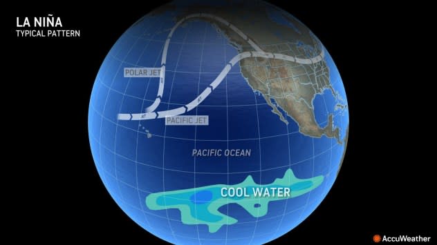
The two phenomena are linked to the area of the Pacific Ocean south of Hawaii near the equator. When the water in this region of the ocean is at least 0.9 of a degree Fahrenheit above the historical average for at least three consecutive months, it results in El Niño. When the waters cool off to at least 0.9 of a degree Fahrenheit below average, La Niña is declared.
 |
When the waters cool off to at least 0.9 of a degree Fahrenheit below historical average, La Niña is declared. |
While this may sound like a small change in temperature, it can cause significant changes in the weather patterns around the globe.
The timing of La Niña's arrival may coincide with the peak of the upcoming Atlantic hurricane season.
"A return to La Niña conditions quickly over the summer could result in an active tropical season," Pastelok said. However, he added that if it is slower to develop, the tropics may not be quite as active during the 2024 hurricane season.
 |
This image provided by the National Hurricane Center National Oceanic and Atmospheric Administration shows a satellite view as Hurricane Fiona moves up the United States Atlantic coast, Thursday night, Sept. 22, 2022. (NOAA via AP) |
If La Niña does come to fruition, it may also have a heavy hand in the weather forecast for the United States next winter. It generally results in a dry and mild winter in the South, a colder winter in the Northeast and frequent storms in the Northwest, although it is still too early to make the call on what next winter will bring.
 |
Typical La Nina winter weather impacts include wet weather in the Northwest, shots of cold air in New England, and predominantly dry and mild in the South. |
Want next-level safety, ad-free? Unlock advanced, hyperlocal severe weather alerts when you subscribe to Premium+ on the AccuWeather app. AccuWeather Alerts™ are prompted by our expert meteorologists who monitor and analyze dangerous weather risks 24/7 to keep you and your family safer.
