
Gulf storm bringing much-need rain, Florida tornado threat

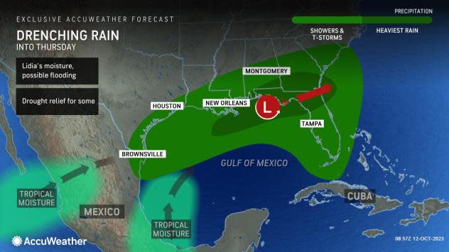

A drenching rainstorm AccuWeather meteorologists have had their eyes on since the start of October has come to fruition, albeit without developing into a named tropical system. The storm will bring drought-easing rain to several locations, but it will come at the cost of localized urban flooding in parts of the Southeast and a few tornados in Florida, forecasters warn.
Stiff winds at mid-levels of the atmosphere, known as wind shear, and a press of cool air into the Gulf of Mexico will prevent the system from organizing into a named tropical storm.
 |
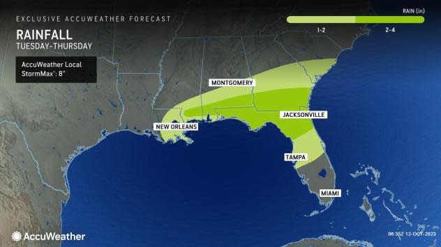
The steady movement of the system will limit the potential for extreme rainfall that can sometimes occur with stalled or slow-moving tropical storms. However, a general 2-4 inches of rain will fall across southern Georgia and northern Florida into Thursday. Within this swath, local amounts of 4-6 inches of rain are likely with an AccuWeather Local StormMax™ of 8 inches.
Where the ground is dry, the parched earth may not be able to absorb all of the rain since rainfall rates may approach 2 inches per hour. The heaviest downpours will threaten flooding in low-lying areas.
However, in most cases, the rain will be welcomed due to the ongoing drought which has escalated to the most extreme level since the summer. Not enough rain will fall, and it will not occur far enough to the north to have a significant or lasting impact on water levels over the lower part of the Mississippi River.
 |
Dry air over the interior southeastern United States will limit the rain's northern and western reach. Any chances of the rain advancing will end as the storm heads quickly out to sea Thursday.
The other significant aspect of the storm will be thunderstorm activity.
While the southeastern U.S. is no stranger to robust summertime thunderstorms, the storms into Thursday morning may pack quite a punch in the region and pose a moderate risk to lives and property in some cases.
"There will be some nasty thunderstorms in Florida Wednesday night," AccuWeather Chief On-Air Meteorologist Bernie Rayno said.
 |
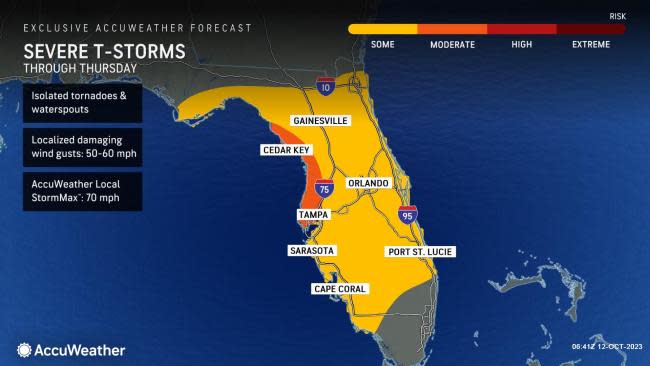
Some of the strongest storms are likely to produce tornadoes. As of early Thursday morning, there have been over 20 tornado warnings issued across the sunshine state since Wednesday afternoon. Additionally, two touchdowns were reported to have occurred late Wednesday night by the Storm Prediction Center.
Back on Wednesday morning, Rayno was pointing toward a special thunderstorm complex over the northern Gulf of Mexico called a "V-notch." This represents a v-shaped area of intense thunderstorms that can be tracked as it moves.
Even outside of the thunderstorm complex, individual thunderstorms and groups of thunderstorms may produce damaging wind gusts, flash flooding and a tornado.
At this time, the main threat of severe weather includes much of the Florida Peninsula, but there will also be some locally severe storms that extend farther to the north into parts of the panhandle.
Forecasters recommend that people stay up to date on any severe weather watches and warnings. Some bulletins may contain information on tornadoes as well. If a severe thunderstorm or tornado watch is issued, it means that the conditions are possible, and a severe thunderstorm or tornado warning means that the conditions are imminent or may already be occurring.
People in the zone from Tampa and Orlando to Tallahassee and Jacksonville, Florida, should especially pay close attention to the situation through Thursday.
In addition to the severe thunderstorm and tornado threat, some of the stronger storms can produce waterspouts along the Gulf and southern Atlantic coasts.
The combination of drenching rain, locally strong winds and severe thunderstorms will increase the likelihood of airline delays and flight cancellations in the region.
 |
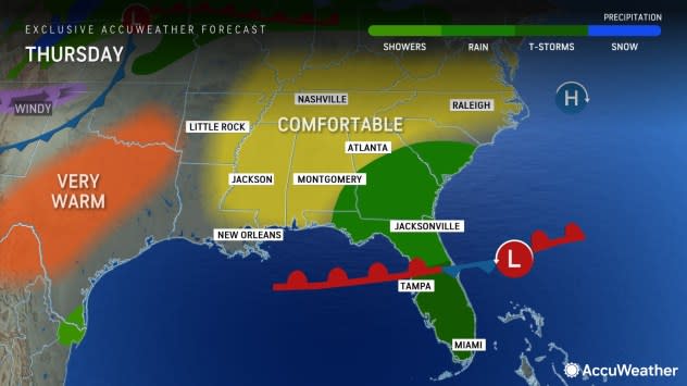
The risk of severe weather will wind down Thursday as the storm pushes to the Atlantic coast and offshore. However, there may still be locally heavy, gusty thunderstorms for a time over the Florida Peninsula.
Want next-level safety, ad-free? Unlock advanced, hyperlocal severe weather alerts when you subscribe to Premium+ on the AccuWeather app. AccuWeather Alerts™ are prompted by our expert meteorologists who monitor and analyze dangerous weather risks 24/7 to keep you and your family safer.
