
Blizzard conditions, ice snarl travel in northern Plains


A storm that dropped a fresh blanket of snow across the interior West over the weekend began strengthening across the middle of the nation on Christmas Day, bringing treacherous travel with snow-covered roads to the northern High Plains. AccuWeather forecasters say a blizzard will continue through Tuesday night for some locations while freezing rain turns streets and sidewalks into naturally made skating rinks farther to the north and east.
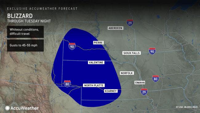
Blizzard warnings were hoisted early Sunday morning across a wide swath of Nebraska and parts of neighboring South Dakota. These were later expanded to include portions of northwestern Kansas and eastern Colorado. Experts say windblown snow in these areas will make it difficult to see on the roadways at times.
 |
"This storm arrived just in time to bring a white Christmas for some in the Rockies and Plains," AccuWeather Senior Meteorologist Tyler Roys said.
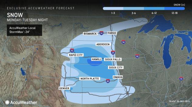
The highest snow totals are expected to focus west of I-29 around the I-80 and I-90 corridors of Nebraska and South Dakota. In this zone, more than a foot of snow can fall.
"The duration of the storm will add to the wintry feel through midweek for any holiday activities," Roys explained.
 |
Gusty winds are expected to contribute to difficult travel and create an all-out blizzard for some locations that will last beyond the Christmas holiday. Widespread blowing and drifting snow will significantly hamper visibility on the roadways through Tuesday night.
In the heaviest snow bands, snow can accumulate several inches in just a few hours, making it difficult for road crews to keep streets and interstates clear. Motorists who are out at the height of the storm may run the risk of becoming stranded.
On Monday, there were reports of multiple semi-trucks crashing on Interstate 80 near York, Nebraska, as snow fell at a heavy pace.
#NSP I-80 eastbound at the York exit is closed due a multi-vehicle crash. https://t.co/2mEjgG28Ik pic.twitter.com/C2M8Jc9mES
— Nebraska 511 (@Nebraska511) December 25, 2023
Bands of snow began to push southward on Tuesday to include much of the I-70 corridor from eastern Colorado through central Kansas. Motorists taking to the roads in this zone into the nighttime hours should be prepared for periods of snow and wintry travel conditions with the potential for substantial delays.
During Tuesday night and Wednesday morning, the bands of snow will also expand eastward along I-70 with areas from Kansas City, Missouri, through central Missouri at risk for slippery travel.
Later in the week, pockets of flurries and accumulating snow will pivot over the interior Southeast states. For some, this will bring the first snowflakes and accumulation of the winter season.
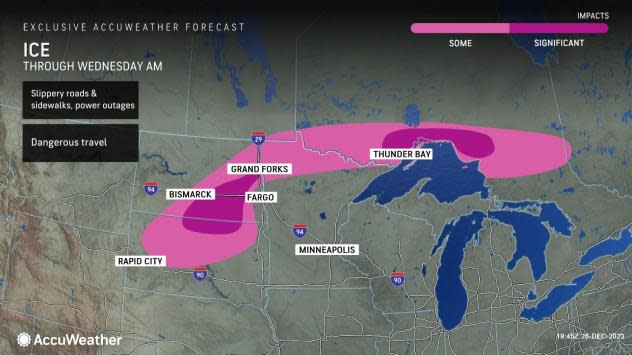
AccuWeather meteorologists say the storm poses an ice risk to the east and north of the heaviest snowfall.
Freezing rain will continue in communities west of Fargo, North Dakota, and into northern Minnesota into Tuesday night. Residents and visitors traveling to their holiday destinations will want to use extreme caution as roads that may appear wet can be coated with a dangerous layer of ice.
 |
Enough ice can accumulate for tree branches to snap and weigh down power lines, perhaps resulting in power outages. In western Minnesota, there was a report of 0.50 of an inch of ice with large tree branches down on Christmas Day. As of Tuesday afternoon, ice accretions on elevated surfaces were approaching 0.50 of an inch in portions of the Dakotas, with significant damage to trees and power lines.
By the middle of the week, the massive storm will unravel over the center of the country, with lingering snow showers and flurries in its wake.
In the final days of December and 2023, most of the Plains states look dry and chilly going into New Year's weekend.
Want next-level safety, ad-free? Unlock advanced, hyperlocal severe weather alerts when you subscribe to Premium+ on the AccuWeather app. AccuWeather Alerts™ are prompted by our expert meteorologists who monitor and analyze dangerous weather risks 24/7 to keep you and your family safer.
