
Southeastern US downpours to be double-edged sword into Sunday

The potential for drenching to locally severe thunderstorms will continue in parts of the southern United States through the start of the weekend, AccuWeather meteorologists say. Along with a continued risk of severe weather, drought-easing and travel-disrupting rain will ruin outdoor plans, with the chance of flash flooding as a second storm emerges.
The first storm that crossed the region Thursday into Thursday night produced rain that extended from the Gulf of Mexico to much of the Mississippi and lower Ohio valleys. Thunderstorms, some packing flash flooding, shifted slowly from central Texas to northeastern Texas and western Louisiana.
 |
The first storm moved northward into the Northeast on Saturday as more rain and thunderstorms gathered near the central Gulf coast as a second storm took shape. By Saturday morning, some locations along the Gulf coast had already picked up 3-6 inches of rain. In Pensacola, Florida, there were reports of floodwaters covering roadways.
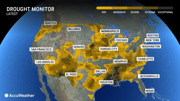
According to the United States Drought Monitor, much of the region is experiencing conditions ranging from abnormally dry to exceptional drought - the worst drought category.
 |
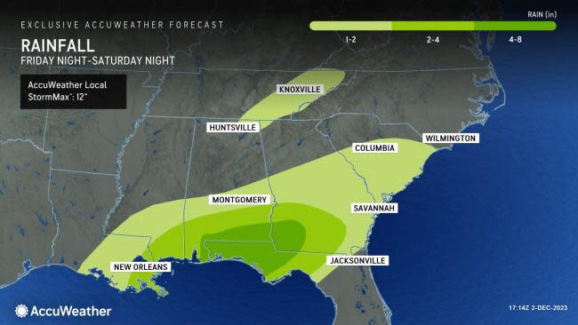
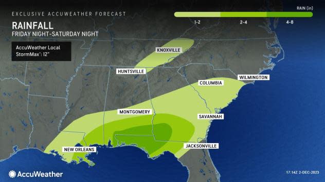
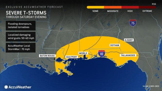
In total, 4-8 inches of rain can pour down across the Florida Panhandle, extending into southern Alabama and southwestern Georgia, in the timeframe spanning Friday night through Saturday night. There is an AccuWeather Local StormMax™ of 12 inches.
 |
Too much rain may pour down too quickly in some urban areas, such as Mobile, Alabama, and Pensacola, Florida, which could result in ponding on some city streets and highways.
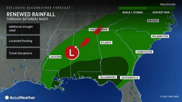
"It is as the second storm begins to roll northeastward from the Gulf into Saturday night, that just enough warm air may be pulled northward to allow a zone of severe thunderstorms from southeastern Louisiana to the Florida Panhandle," AccuWeather Senior Meteorologist Adam Douty said.
 |
The scope of the severe weather will depend on how much warm air expands versus a wedge of cool air east of the Appalachians. The severe weather risk may extend farther to the east along the southern Atlantic coast for a time Saturday night.
Some of the worst drought conditions continue across portions of Louisiana and Mississippi, where rainfall in some areas is only one-quarter of the historical average since the start of July and before Thursday's storm.
The bulk of the rain will leave the region during Saturday night. However, as a cold front approaches and pushes through the region on Sunday, one more round of showers and perhaps a thunderstorm is in store from the northeast Gulf to the Carolinas and southern Virginia.
The same storm system will spread drenching rain into the mid-Atlantic by Sunday with snow in northern New England from Sunday night to Monday.
By Monday, the cold front will slide slowly southward through the Florida Peninsula with spotty showers and thunderstorms as dry air expands over the Southeast region. Much of the new week will be dry before moisture returns from the Gulf of Mexico towards next weekend.
Want next-level safety, ad-free? Unlock advanced, hyperlocal severe weather alerts when you subscribe to Premium+ on the AccuWeather app. AccuWeather Alerts™ are prompted by our expert meteorologists who monitor and analyze dangerous weather risks 24/7 to keep you and your family safer.
