
Dramatic pattern shift to erase spring preview in Central, Eastern US

The domineering pattern of dry weather, abundant sunshine and unusual warmth across the central and eastern United States will soon come to an end, with AccuWeather forecasters predicting a major shift in the weather pattern later this week. The dry and unseasonably mild conditions across parts of the Great Lakes and Ohio Valley will be replaced by a damp and cooler pattern.
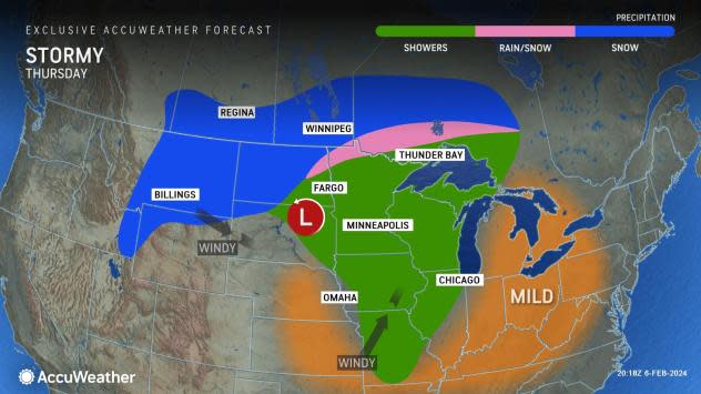
The significant shift in the weather across the Midwest and Northeast will be caused by cold air plunging southward from Canada and a storm emerging from the Rocky Mountains.
Cities such as Minneapolis and Chicago will transition from the 50s Fahrenheit around midweek to daytime highs in the 40s and 30s this weekend into the start of next week.
Residents may want to soak up the nicer, springlike conditions as much as they can through the middle to late parts of the week because Mother Nature will soon revoke the mild weather and Old Man Winter will rear his head once again.
"The Northeast and Great Lakes have been basking in the sunshine over the past weekend and start of this week," AccuWeather Meteorologist Dean DeVore said.
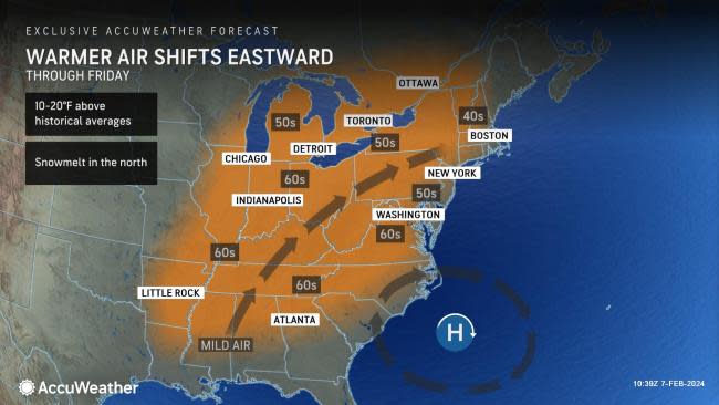
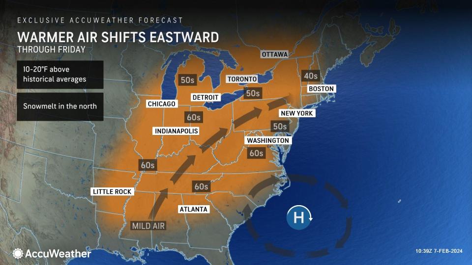
Warmth originating from the middle of the country then expanding north and east during the second half of the week will boost temperatures for millions of people.
 |
Most cities from the Plains to the Northeast will notice a 5- to 15-degree Fahrenheit shift from Wednesday and Thursday to Sunday and Monday. Temperatures in locations across the central and southern Plains such as Little Rock, Arkansas, Shreveport, Louisiana, and Dallas can even rise into the 70s by Thursday or Friday.
By later this weekend into early next week, most of these locations in the southern Plains can revert to high temperatures in the 50s as the cooler air pushes farther south.
As the late-week storm tracks eastward into the northern Plains, it will bring periods of rain, snow and wind. Gusts can range from 30-40 mph across the central Plains as the front sweeps across the region.
Snow can spread across parts of the northern Rocky Mountains, North Dakota and south-central Canada as this storm advances into the Plains. A corridor will likely set up where a mixture of rain and snow can separate the warmer, rainy sector of the storm from the snowy conditions on the rear flank.
 |
Thursday in the Northeast may turn out to be the nicest day of the week in terms of dry weather and above-historical average temperatures. Clouds will begin to arrive ahead of the storm, but they won't prevent the mercury from climbing even higher, with daytime highs upwards of 20 degrees above typical early-February temperatures.
By Friday, rain and showers will begin to transfer into the Ohio Valley and interior Northeast, with the chance of some showers stretching southward into the Tennessee Valley. Closer to the mid-Atlantic coast, the mild conditions may peak closer to Saturday as the storm's energy and moisture slowly shift eastward.
"Temperatures likely reach their peak along the I-95 corridor at the start of this weekend," added DeVore.
However, by midday Saturday, showers can begin to creep into the I-95 corridor to dampen cities like Philadelphia and New York City, depending on the track of the storm later this week.
 |
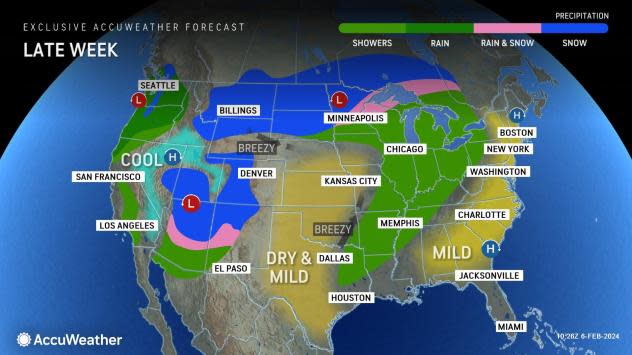
Looking ahead, residents in the East may notice an uptick in stormy weather after this week. Temperatures can trend closer to typical February values across the country's northern tier.
"A 'word to the wise,' enjoy the next 10 days or so, because some winter cold and winter-type weather will likely come back into play for the Eastern US prior to and even beyond Valentine's Day for the second half of February," added DeVore.
AccuWeather Senior Meteorologist and Lead U.S. Long-Range Forecaster Paul Pastelok has highlighted for weeks that a pattern will develop by mid-February and continue into early March, supporting more wintry, colder weather for the eastern half of the nation, especially the Northeast and mid-Atlantic.
Want next-level safety, ad-free? Unlock advanced, hyperlocal severe weather alerts when you subscribe to Premium+ on the AccuWeather app. AccuWeather Alerts™ are prompted by our expert meteorologists who monitor and analyze dangerous weather risks 24/7 to keep you and your family safer.
