
Dangerous ice, snow to lead warmup in Midwest and Northeast


A major warmup will lead to a January thaw over much of the Midwest and Northeast this week. However, as moisture surges into the regions, enough cold air will linger at the onset of the pattern flip to lead to slippery travel from ice and/or snow in nearly a dozen states into Wednesday, AccuWeather meteorologists warn. The thaw itself may also result in travel issues as well.
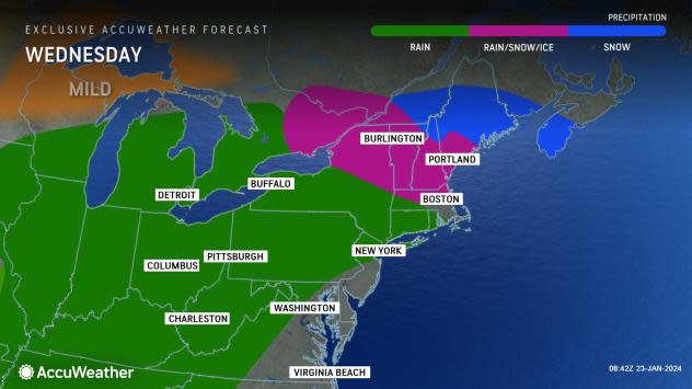
A glaze of ice encased exposed surfaces and shut down travel from Oklahoma to Illinois on Monday morning. However, even though milder air moving in over much of the Mississippi Valley has helped to thaw the ice, the leading edge of the rain will freeze on trees, roads and sidewalks from southern Wisconsin and Michigan to New York state and New England into midweek.
Where the ice accretes to a thickness of about 0.25 of an inch or greater, it may weigh trees down enough to cause them to break and trigger power outages. However, this amount of ice in the Northern states will likely be highly localized.
Any ice accretion is dangerous for motorists and pedestrians. The ice may be so thin as to appear wet, and various textures of the ice may provide traction in one spot but be extremely slippery in another.
The icy zone is expected to shift into northeastern New York and more of central and northern New England for a time on Wednesday.
 |
The freezing rain setup is caused by a shallow layer of cold air nearest to the ground as much warmer air flows in at the middle and upper layers of the atmosphere.
Where the cold layer is thicker across more of the northern tier, snow and sleet will occur instead of freezing rain.
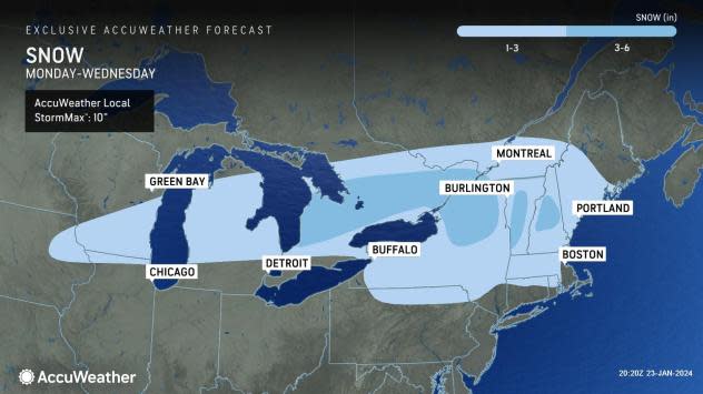
That cold layer will be thick enough to support accumulating snow to fall for a time, mainly from eastern Iowa and southern Wisconsin to upstate New York, the northern tier of Pennsylvania and New England, where 1-6 inches of snow will fall.
The snow may start dry and powdery but become wet and slushy as temperatures rise with the potential for some sleet to mix in with the snow.
 |
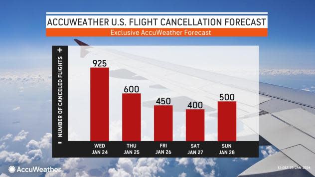
Many airline delays and flight cancellations will occur due to snow, ice or fog. Some of the major Midwest hubs to be most affected will be Chicago, Detroit and Cleveland.
Even though wintry conditions will avoid most major hubs in the Northeast, secondary regional airports, a beginning and final destination for many airline passengers, will be adversely affected as crews and aircraft are displaced on Wednesday.
 |
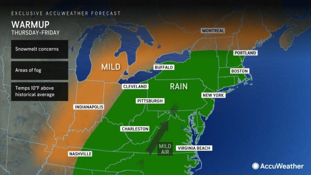
There is the potential for fog to form in areas where the air temperature rises above freezing quickly and the ground is just wet, such as in Boston, Pittsburgh, New York City, Philadelphia and Washington, D.C. This can lead to additional ground stops, flight delays and cancellations this week, even when temperatures rise well above the historical average for late January.
Highs in the 40s, 50s and 60s may be widespread during the second half of this week as the January thaw kicks into high gear.
The thaw will be accompanied by areas of clouds and rain, even if fog is absent. Through Friday, most of the rainy episodes will occur from the northwestern Gulf Coast to the lower Mississippi River Valley, the Ohio Valley and eastward to much of the Atlantic coast. Motorists may encounter ponding during their travels as a series of storms rolls up from the Gulf of Mexico.
 |
There is the potential for locally dense fog to develop due to the cold ground or remaining snow cover leading to extra condensation.
The brevity of the Arctic cold allowed only a relatively thin layer of ice to form on northern ponds, lakes and streams, AccuWeather Senior Meteorologist Joe Lundberg said.
The combination of rising temperatures and rain thrown in with already high stream levels may lead to some flooding along unprotected waterways.
"Because of the thin ice, only localized problems from ice jams are likely as the thaw builds," Lundberg stated.
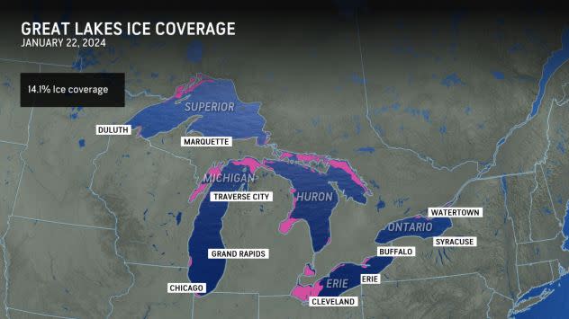
Ice coverage on the Great Lakes, sitting at 14% as of Monday, Jan. 22, is well behind the historical average for late January, according to the Great Lakes Environmental Research Laboratory. Typical ice coverage in late January is about 25% and peaks in late February to early March.
 |
"The breakup of the thin ice will also pose dangers to fishing interests and other frozen lake enthusiasts in the region," AccuWeather Meteorologist Brandon Buckingham said, adding, "Little ice last winter and so far this winter has caused the ice fishing and other industries in the Midwest and Northeast to take a hit."
Want next-level safety, ad-free? Unlock advanced, hyperlocal severe weather alerts when you subscribe to Premium+ on the AccuWeather app. AccuWeather Alerts™ are prompted by our expert meteorologists who monitor and analyze dangerous weather risks 24/7 to keep you and your family safer.
