More days of severe weather, flooding downpours ahead for storm-weary central US
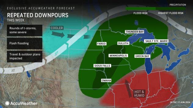
A stalled pattern across the United States, featuring a building heat dome in the East and waves of cool air in the Northwest, will put the middle of the nation at risk for daily rounds of severe thunderstorms through Tuesday. AccuWeather meteorologists warn that flash flood dangers may mount as the stormy weather repeats right through the end of the week.
The zone from Kansas to Minnesota will be positioned in an atmospheric bottleneck of sorts, where moisture from the Gulf of Mexico will meet up with storms rolling in from the Pacific Ocean, resulting in days of downpours.
While there will be some periods of dry weather to enjoy, the cumulative impact of the wet weather in this area could lead to more than just temporary travel and outdoor activity disruptions, despite not every day being a complete washout. People who have outdoor plans scheduled this week are encouraged to keep an eye on the sky and heed any warnings issued.
There will be no rest for the weary as the same areas that faced severe weather and flooding downpours this past weekend will face more rounds of potentially damaging thunderstorms as a weather front wobbles across the north-central United States.
Through Tuesday, that area at risk for damaging thunderstorms will feature a similar corridor from Nebraska through Minnesota and into southwestern Ontario. By Tuesday night, potent thunderstorms can develop farther south as well, into part of Kansas. Flash flooding may be the greatest concern after dark as storms lose their wind potency but drench the same areas in heavy rainfall.
Minneapolis is included in the zone where thunderstorms can pack a punch with hail, high winds and downpours. An isolated tornado or two cannot be ruled out.
 |
"Those traveling on interstates 29, 35, 90 and 94 will want to have alerts enabled on their AccuWeather app as these storms and downpours could threaten travel plans," Pydynowski said.
Secondary roadways may be blocked by debris in the form of fallen trees and downed powerlines. Hail and isolated tornadoes will be among the severe weather hazards possible early this week, in addition to damaging wind gusts.
Tuesday may produce a more widespread severe thunderstorm risk, in terms of the number of reports, when compared to the beginning of the week. In addition, wind gusts in thunderstorms will not have to be as high to cause trees to topple over because the ground will be saturated in some areas by this point.
AccuWeather's expert long-range team expects the bottlenecked pattern to remain in place into the last full week of June, resulting in additional rounds of severe weather and downpours across the northern tier of the nation's midsection.
Each round of thunderstorms could unload 1-3 inches of rain, with locally higher amounts possible where thunderstorms sit for an extended time or move over the same general area in a phenomenon known to meteorologists as "training" thunderstorms. Through this week, some locations that get hit more than once could receive over half a foot of rain.
 |
AccuWeather expects the flash flood risk to be highest by the latter part of this week and this weekend due to the cumulative effect of the days of rain leading up to that time frame.
Experts urge motorists to be vigilant and to avoid areas of high water. Flooded roadways are particularly difficult to properly assess at night.
Additional reporting by AccuWeather meteorology intern Peyton Simmers.
Want next-level safety, ad-free? Unlock advanced, hyperlocal severe weather alerts when you subscribe to Premium+ on the AccuWeather app. AccuWeather Alerts™ are prompted by our expert meteorologists who monitor and analyze dangerous weather risks 24/7 to keep you and your family safer.


