
Brisk, wintry pattern spreading across the Midwest for Halloween

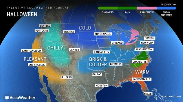
AccuWeather meteorologists say that the Halloween holiday may feature more than ghosts and ghouls this year across the North Central states. A chilly, windy pattern will set up across the region and spread winterlike conditions to a few of the major metro areas.
A southward plunge in the jet stream across the Plains will help to direct a bitterly cold air mass southward out of the Canadian Prairies, bringing some of the coldest air of the season so far for some cities in the region early this week in addition to chances of snow.
Forecasters say that a widespread chill will expand across the northern Plains into the Great Lakes region into the early parts of the week, with metro areas such as Chicago on track to observe daytime highs ranging into the 30s for the first time this season.
 |
"Mother Nature will likely be dealing out more tricks than treats for residents across the Midwest on Halloween, as a cold, blustery and potentially snowy scene is expected. Places such as Milwaukee and Madison, Wisconsin, Grand Rapids, Michigan, and even Chicago could end up getting their first snowflakes of the season right around the time kids venture out for trick-or-treating," explained AccuWeather Meteorologist Brandon Buckingham.
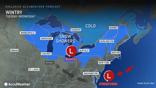
Forecasters have been monitoring the pattern for All Hallow's Eve closely over the last week, saying that a feature tracking over the Great Lakes will bring a quick swath of snow showers to the region.
"The threat of snow across the Midwest Tuesday and Tuesday night will arise from a clipper system that will quickly dive out of Canada. These systems typically do not feature a lot of precipitation as they pass through, but they can frequently be accompanied by a surge of cold and windy conditions," added Buckingham.
 |
Locations across northeastern North Dakota into Minnesota will face the best chance of snowflakes from Monday evening to Tuesday, including places such as Grand Forks, North Dakota, as well as Duluth and the Minneapolis-St. Paul area of Minnesota.
Residents in Minneapolis are projected to have a max temperature in the mid-30s on Halloween with occasional snow showers persisting into the morning hours. In contrast to last Halloween, which turned into the warmest recorded Oct. 31 in roughly 20 years, this year in Minneapolis will prove to be much colder, with high temperatures ranging between 25 and 30 degrees less than what was recorded last year.
If the forecast high of 35 F comes to fruition in Minneapolis on Tuesday, it will be the coldest Halloween since 2019.
As the storm continues to track southeastward from Canada and across the Great Lakes from the early to middle parts of the week, the associated cold front will kick up winds from the Dakotas to Missouri and Illinois. Residents are cautioned to secure their jack-o'-lanterns and various outdoor Halloween decorations, as some locations can observe gusts upwards of 35 mph during the early-week timeframe.
On Tuesday, it may remain breezy into the early afternoon over parts of central and southern Minnesota with winds ranging between 10 and 20 mph across the region. However, conditions are likely to turn calmer across the Minneapolis-St. Paul metro area with light winds expected by sunset.
By the evening hours on Halloween, temperatures are expected to creep into the upper 20s around the Twin Cities, prompting any trick-or-treaters to wear a few extra layers under their costumes.
 |
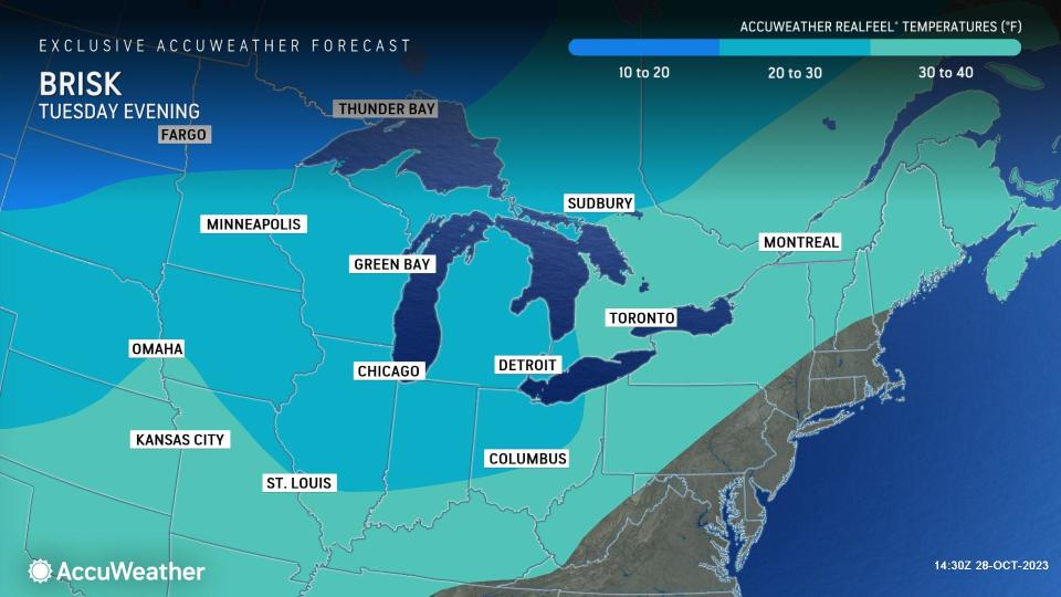
As the sunlight fades, AccuWeather RealFeel® Temperatures will trend a few degrees in the lower to mid-20s Tuesday evening across much of southeastern South Dakota, southern Minnesota, Wisconsin and Michigan. Farther north across North Dakota and northern Minnesota, AccuWeather RealFeel® Temperatures can even range down to the teens on Halloween night.
"While it will be rather chilly this year for trick-or-treaters, it could be worse. The Halloween Blizzard of 1991 still holds the crown as one of the coldest and snowiest Halloweens on record for the Twin Cities. Residents in Minneapolis picked up 28.4" of snow between Oct. 31 and Nov. 2 that year," explained AccuWeather Senior Meteorologist Matt Benz.
Forecasters say that it is not out of the ordinary for frigid conditions to sweep across the Midwest this time of year. On numerous occasions over the course of the last 20 years, residents have recorded daytime highs ranging into only the mid-30s to around 40 degrees.
Want next-level safety, ad-free? Unlock advanced, hyperlocal severe weather alerts when you subscribe to Premium+ on the AccuWeather app. AccuWeather Alerts™ are prompted by our expert meteorologists who monitor and analyze dangerous weather risks 24/7 to keep you and your family safer.
