
Blistering heat wave to have interior West searing into second week of June


The first widespread major heat wave of the year will bake many areas of the interior West with triple-digit temperatures this weekend and into next week. AccuWeather meteorologists continue to remind people of the danger of wildfires and the risk of lightning as thunderstorms erupt over some of the region's mountain ranges.
A bulge in the jet stream in the western United States, combined with a storm just offshore over the Pacific Ocean, will pump temperatures to their highest levels since last summer from interior locations of California and Oregon to the Rockies, encompassing nearly a dozen states.
In most areas, the peak of the heat already occurred prior to Saturday, but parts of the Great Basin may experience surging temperatures this weekend. The extreme heat will also be felt in portions of Idaho, Wyoming, Colorado, Oregon and New Mexico.
Intense June sunshine will negate the dry air effects and push AccuWeather RealFeel® Temperatures to extremely dangerous levels each day.
 |
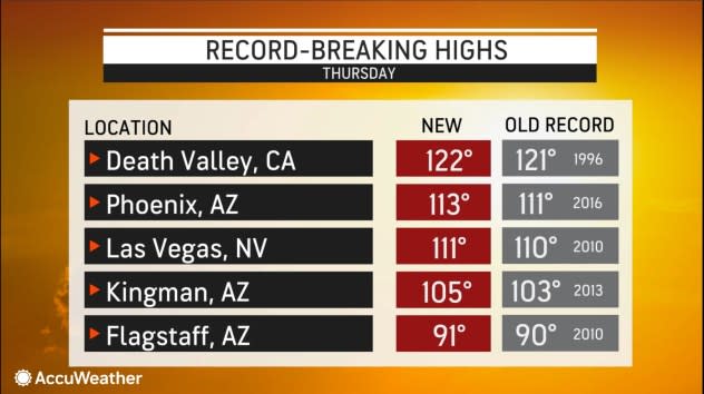
Through Friday, the notoriously hot cities of Las Vegas and Phoenix have had two consecutive days of high temperatures at or above 110 degrees Fahrenheit. While temperatures in Las Vegas are expected to throttle back a bit this weekend, another high of 110 is forecast of Phoenix on Saturday. However, even in these sizzling summertime cities, these temperatures are 8-12 degrees above the historical average for June.
Salt Lake City will have multiple days with highs in the 90s through Sunday, but the record of 101 set in 1973 on Sunday may be challenged. Boise, Idaho, can expect highs near or in the 90s through at least Tuesday.
Death Valley cracked the 120-degree mark for the first time this year Thursday, reaching 122 degrees, a level of heat not usually experienced in the hottest place in North America until June 24.
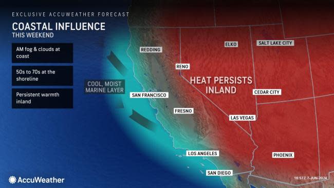
With so much of the interior West heating up, cool air must sweep in to take its place somewhere. That will occur along much of the Pacific coast. The condition, often called "June gloom" or sometimes "Juneuary," is when the beaches and communities a few miles inland remain under low clouds most of the day with a damp chill in the air.
 |
A light breeze from the Pacific Ocean, known as a marine layer, will help to keep the extreme heat away from the beaches and coastal cities, including San Diego, Los Angeles, San Francisco, Seattle and Portland, Oregon. For example, highs in downtown Los Angeles will generally be in the 70s right into early next week. Some coastal communities will have highs in the low-to-mid-60s.
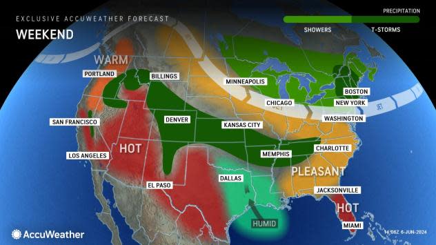
This weekend, the jet stream will shuffle around as a storm drops southward from the Canadian Prairies to the North Central states. In addition to trimming daily highs back just a bit in many areas of the interior West, the cooler air at the level where jet streams fly can trigger pop-up thunderstorms.
 |
Cooler air will push southward along the eastern slopes to the Continental Divide this weekend. For example, in Denver, following temperatures surging into the mid-90s on Friday, a sweep of cooler air will result in highs near 80 degrees over the weekend.
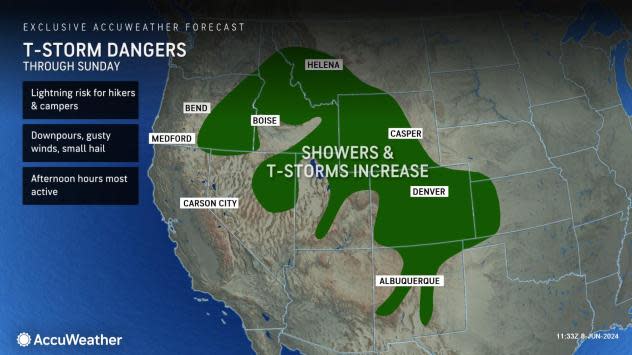
Most thunderstorms will occur over the ridges in the Rockies and the Wasatch Range. As the storm from the Pacific Ocean inches eastward, some storms will also erupt in the Cascades and Sierra Nevada. A smaller number of storms may wander out of the mountains and onto the valleys and basins.
The thunderstorm activity-most notably, lightning strikes-will affect hikers who venture into the mountains. Anyone above the treeline or in open areas will be at the greatest risk of being struck by lightning. The safest method is to start early and head down the mountain by noontime.
 |
The storms should avoid the desert locations and arid canyons, which are most prone to flash floods farther along in the summertime.
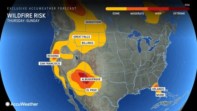
Lightning strikes will also raise the risk of wildfires, especially in grassy areas. Much of the tree canopy is green and lush so far this year due to the ample rain and mountain snow that fell, which was able to penetrate deep into the ground. The topsoil and grass tend to dry quickly in heat and can easily be ignited by lightning or open flames, hot exhaust and power equipment.
 |
As of early Saturday morning, at least five major wildfires were actively burning over California alone, consuming nearly 4,000 acres, according to CalFire. The largest fire of the season so far-the Corral Fire-had burned more than 14,100 acres but is fully contained.
Temperatures will fluctuate west of the Rockies this weekend but may surge again early next week before trending downward more significantly later next week.
Want next-level safety, ad-free? Unlock advanced, hyperlocal severe weather alerts when you subscribe to Premium+ on the AccuWeather app. AccuWeather Alerts™ are prompted by our expert meteorologists who monitor and analyze dangerous weather risks 24/7 to keep you and your family safer.
